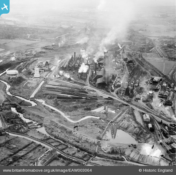
EAW003064 ENGLAND (1946). The Devonshire Works, Staveley, 1946
© Copyright OpenStreetMap contributors and licensed by the OpenStreetMap Foundation. 2025. Cartography is licensed as CC BY-SA.
Nearby Images (24)
Details
| Title | [EAW003064] The Devonshire Works, Staveley, 1946 |
| Reference | EAW003064 |
| Date | 8-October-1946 |
| Link | |
| Place name | STAVELEY |
| Parish | STAVELEY |
| District | |
| Country | ENGLAND |
| Easting / Northing | 442591, 374872 |
| Longitude / Latitude | -1.3613196021934, 53.268850019409 |
| National Grid Reference | SK426749 |
Pins
Be the first to add a comment to this image!


![[EAW003064] The Devonshire Works, Staveley, 1946](http://britainfromabove.org.uk/sites/all/libraries/aerofilms-images/public/100x100/EAW/003/EAW003064.jpg)
![[EAW009691] The Staveley Coal and Iron Co Ltd Devonshire Works, Staveley, 1947](http://britainfromabove.org.uk/sites/all/libraries/aerofilms-images/public/100x100/EAW/009/EAW009691.jpg)
![[EPW041680] The Devonshire Iron and Chemical Works, Staveley, 1933](http://britainfromabove.org.uk/sites/all/libraries/aerofilms-images/public/100x100/EPW/041/EPW041680.jpg)
![[EAW003070] The Devonshire Works and environs, Staveley, from the east, 1946](http://britainfromabove.org.uk/sites/all/libraries/aerofilms-images/public/100x100/EAW/003/EAW003070.jpg)
![[EPW057332] The Staveley Coal and Iron Company Ltd Works, Staveley, 1938](http://britainfromabove.org.uk/sites/all/libraries/aerofilms-images/public/100x100/EPW/057/EPW057332.jpg)
![[EPW041674] The Devonshire Iron and Chemical Works, Staveley, 1933](http://britainfromabove.org.uk/sites/all/libraries/aerofilms-images/public/100x100/EPW/041/EPW041674.jpg)
![[EPW057344] The Staveley Coal and Iron Company Ltd Works, Staveley, 1938](http://britainfromabove.org.uk/sites/all/libraries/aerofilms-images/public/100x100/EPW/057/EPW057344.jpg)
![[EPW041676] The Devonshire Iron and Chemical Works, Staveley, 1933](http://britainfromabove.org.uk/sites/all/libraries/aerofilms-images/public/100x100/EPW/041/EPW041676.jpg)
![[EPW057347] The Staveley Coal and Iron Company Ltd Works and the edge of the town, Staveley, 1938](http://britainfromabove.org.uk/sites/all/libraries/aerofilms-images/public/100x100/EPW/057/EPW057347.jpg)
![[EAW009690] The Staveley Coal and Iron Co Ltd Devonshire Works, Staveley, 1947](http://britainfromabove.org.uk/sites/all/libraries/aerofilms-images/public/100x100/EAW/009/EAW009690.jpg)
![[EPW057353] The Staveley Coal and Iron Company Ltd Works, Staveley, 1938](http://britainfromabove.org.uk/sites/all/libraries/aerofilms-images/public/100x100/EPW/057/EPW057353.jpg)
![[EAW044346] The Staveley Coal and Iron Company Ltd Works, Staveley, 1952](http://britainfromabove.org.uk/sites/all/libraries/aerofilms-images/public/100x100/EAW/044/EAW044346.jpg)
![[EPW057346] The Staveley Coal and Iron Company Ltd Works and the edge of the town, Staveley, 1938](http://britainfromabove.org.uk/sites/all/libraries/aerofilms-images/public/100x100/EPW/057/EPW057346.jpg)
![[EAW044350] The Staveley Coal and Iron Company Ltd Works, Staveley, 1952](http://britainfromabove.org.uk/sites/all/libraries/aerofilms-images/public/100x100/EAW/044/EAW044350.jpg)
![[EPW041681] The Devonshire Iron and Chemical Works, Staveley, 1933](http://britainfromabove.org.uk/sites/all/libraries/aerofilms-images/public/100x100/EPW/041/EPW041681.jpg)
![[EPW057336] The Staveley Coal and Iron Company Ltd Works, Staveley, 1938](http://britainfromabove.org.uk/sites/all/libraries/aerofilms-images/public/100x100/EPW/057/EPW057336.jpg)
![[EAW003062] The Devonshire Works, Staveley, 1946](http://britainfromabove.org.uk/sites/all/libraries/aerofilms-images/public/100x100/EAW/003/EAW003062.jpg)
![[EAW003063] The Devonshire Works, Staveley, from the south-east, 1946](http://britainfromabove.org.uk/sites/all/libraries/aerofilms-images/public/100x100/EAW/003/EAW003063.jpg)
![[EAW003069] The Devonshire Works, Staveley, 1946](http://britainfromabove.org.uk/sites/all/libraries/aerofilms-images/public/100x100/EAW/003/EAW003069.jpg)
![[EPW041679] The Devonshire Iron and Chemical Works, Staveley, 1933](http://britainfromabove.org.uk/sites/all/libraries/aerofilms-images/public/100x100/EPW/041/EPW041679.jpg)
![[EPW041678] The Devonshire Iron and Chemical Works, Staveley, 1933](http://britainfromabove.org.uk/sites/all/libraries/aerofilms-images/public/100x100/EPW/041/EPW041678.jpg)
![[EAW003067] The Devonshire Works, Staveley, 1946](http://britainfromabove.org.uk/sites/all/libraries/aerofilms-images/public/100x100/EAW/003/EAW003067.jpg)
![[EPW057339] The Staveley Coal and Iron Company Ltd Works and the edge of the town, Staveley, 1938](http://britainfromabove.org.uk/sites/all/libraries/aerofilms-images/public/100x100/EPW/057/EPW057339.jpg)
![[EAW003065] The Devonshire Works, Staveley, 1946](http://britainfromabove.org.uk/sites/all/libraries/aerofilms-images/public/100x100/EAW/003/EAW003065.jpg)