
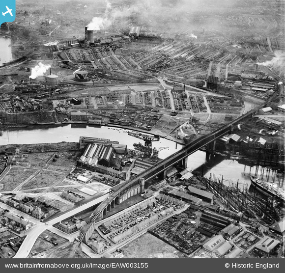
EAW003155 ENGLAND (1946). The Richardsons, Westgarth and Co Marine Engineering Works and Shipbuilding Yard (G. Clark Ltd), Queen Alexandra Bridge and the surrounding area, Sunderland, 1946
© Copyright OpenStreetMap contributors and licensed by the OpenStreetMap Foundation. 2025. Cartography is licensed as CC BY-SA.
Nearby Images (18)
EAW003155
, Queen Alexandra Bridge and the surrounding area, Sunderland, 1946")
EAW003154
, Queen Alexandra Bridge and the surrounding industrial area, Sunderland, 1946")
EAW003164
, Sunderland, from the south-east, 1946")
EAW003166
 alongside Queen Alexandra Bridge, Sunderland, 1946")
EAW003163
, Sunderland, 1946")
EAW001032

EAW003169
 alongside the Queen Alexandra Bridge, Sunderland, 1946")
EAW003167
 alongside Queen Alexandra Bridge, Sunderland, 1946")
EPW054629

EAW003150
 alongside Queen Alexandra Bridge, Sunderland, from the north-east, 1946")
EPW057819

EAW003168
 and the surrounding residential area, Sunderland, 1946")
EAW003162
 and the surrounding industrial area, Sunderland, from the west, 1946")
EPW054628

EAW003165
, Sunderland, 1946")
EAW003153
, Queen Alexandra Bridge and the surrounding industrial area, Sunderland, 1946")
EPW054627

EPW054626

Details
| Title | [EAW003155] The Richardsons, Westgarth and Co Marine Engineering Works and Shipbuilding Yard (G. Clark Ltd), Queen Alexandra Bridge and the surrounding area, Sunderland, 1946 |
| Reference | EAW003155 |
| Date | 23-October-1946 |
| Link | |
| Place name | SUNDERLAND |
| Parish | |
| District | |
| Country | ENGLAND |
| Easting / Northing | 438353, 557795 |
| Longitude / Latitude | -1.4016673404459, 54.913304311781 |
| National Grid Reference | NZ384578 |
Pins
 Matt Aldred edob.mattaldred.com |
Friday 8th of March 2024 01:44:24 PM | |
Matt Aldred edob.mattaldred.com |
Thursday 19th of May 2022 02:15:54 PM | |
 redmist |
Saturday 26th of September 2020 10:56:43 AM | |
redmist |
Saturday 26th of September 2020 10:55:39 AM | |
redmist |
Saturday 26th of September 2020 10:53:09 AM | |
redmist |
Saturday 26th of September 2020 10:52:37 AM | |
redmist |
Friday 25th of October 2019 03:29:05 PM | |
Alan |
Tuesday 2nd of January 2018 05:32:46 PM | |
Alan |
Tuesday 2nd of January 2018 05:28:23 PM | |
Alan |
Tuesday 2nd of January 2018 05:26:53 PM | |
Alan |
Tuesday 2nd of January 2018 05:26:06 PM | |
Alan |
Tuesday 2nd of January 2018 05:25:07 PM | |
Sparky |
Wednesday 13th of September 2017 10:00:25 AM | |
Sparky |
Wednesday 13th of September 2017 09:59:59 AM | |
Sparky |
Wednesday 13th of September 2017 09:59:17 AM |