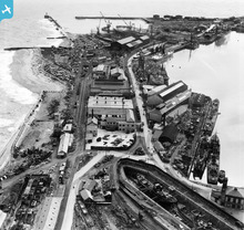
EAW003171 ENGLAND (1946). The North Eastern Marine Engineering Company Works, Sunderland, 1946
© Copyright OpenStreetMap contributors and licensed by the OpenStreetMap Foundation. 2025. Cartography is licensed as CC BY-SA.
Nearby Images (20)
Details
| Title | [EAW003171] The North Eastern Marine Engineering Company Works, Sunderland, 1946 |
| Reference | EAW003171 |
| Date | 23-October-1946 |
| Link | |
| Place name | SUNDERLAND |
| Parish | |
| District | |
| Country | ENGLAND |
| Easting / Northing | 441175, 557622 |
| Longitude / Latitude | -1.3576699706862, 54.911524903402 |
| National Grid Reference | NZ412576 |
Pins
 Matt Aldred edob.mattaldred.com |
Monday 8th of March 2021 07:00:28 PM | |
 redmist |
Saturday 26th of September 2020 11:52:25 AM | |
 redmist |
Saturday 26th of September 2020 11:52:00 AM | |
 redmist |
Saturday 26th of September 2020 11:51:38 AM | |
 redmist |
Sunday 17th of March 2019 11:09:12 PM | |
 cptpies |
Wednesday 3rd of December 2014 08:14:39 AM |
User Comment Contributions
 cptpies |
Wednesday 3rd of December 2014 08:15:43 AM |


![[EAW003171] The North Eastern Marine Engineering Company Works, Sunderland, 1946](http://britainfromabove.org.uk/sites/all/libraries/aerofilms-images/public/100x100/EAW/003/EAW003171.jpg)
![[EAW003176] The North Eastern Marine Engineering Company Works, Sunderland, from the north-west, 1946](http://britainfromabove.org.uk/sites/all/libraries/aerofilms-images/public/100x100/EAW/003/EAW003176.jpg)
![[EPW051128] Hudson Dock, Sunderland, 1936. This image has been produced from copy-negative.](http://britainfromabove.org.uk/sites/all/libraries/aerofilms-images/public/100x100/EPW/051/EPW051128.jpg)
![[EAW003177] The North Eastern Marine Engineering Company Works, Sunderland, 1946](http://britainfromabove.org.uk/sites/all/libraries/aerofilms-images/public/100x100/EAW/003/EAW003177.jpg)
![[EAW003183] The North Eastern Marine Engineering Company Works and the entrance to Sunderland Harbour, Sunderland, 1946](http://britainfromabove.org.uk/sites/all/libraries/aerofilms-images/public/100x100/EAW/003/EAW003183.jpg)
![[EAW003170] The North Eastern Marine Engineering Company Works, Sunderland, from the north-west, 1946](http://britainfromabove.org.uk/sites/all/libraries/aerofilms-images/public/100x100/EAW/003/EAW003170.jpg)
![[EAW003182] The North Eastern Marine Engineering Company Works, the Hudson Dock North and the entrance to Sunderland Harbour, Sunderland, 1946](http://britainfromabove.org.uk/sites/all/libraries/aerofilms-images/public/100x100/EAW/003/EAW003182.jpg)
![[EAW003184] The North Eastern Marine Engineering Company Works and South Rocks, Sunderland, 1946](http://britainfromabove.org.uk/sites/all/libraries/aerofilms-images/public/100x100/EAW/003/EAW003184.jpg)
![[EPW020546] North Half Tide Basin, Hudson Dock North and New South Pier, Sunderland, 1928](http://britainfromabove.org.uk/sites/all/libraries/aerofilms-images/public/100x100/EPW/020/EPW020546.jpg)
![[EAW003180] The North Eastern Marine Engineering Company Works, Sunderland, 1946](http://britainfromabove.org.uk/sites/all/libraries/aerofilms-images/public/100x100/EAW/003/EAW003180.jpg)
![[EAW003172] The North Eastern Marine Engineering Company Works, Maud's Hole and New South Pier, Sunderland, from the south-west, 1946](http://britainfromabove.org.uk/sites/all/libraries/aerofilms-images/public/100x100/EAW/003/EAW003172.jpg)
![[EAW003178] The North Eastern Marine Engineering Company Works, the entrance to Sunderland Harbour and the surrounding area, Sunderland, from the south-east, 1946](http://britainfromabove.org.uk/sites/all/libraries/aerofilms-images/public/100x100/EAW/003/EAW003178.jpg)
![[EAW003175] The North Eastern Marine Engineering Company Works and the entrance to Sunderland Harbour, Sunderland, from the south, 1946](http://britainfromabove.org.uk/sites/all/libraries/aerofilms-images/public/100x100/EAW/003/EAW003175.jpg)
![[EPW020539] Hudson Docks and the harbour entrance, Sunderland, 1928](http://britainfromabove.org.uk/sites/all/libraries/aerofilms-images/public/100x100/EPW/020/EPW020539.jpg)
![[EAW003179] The North Eastern Marine Engineering Company Works, the entrance to Sunderland Harbour and the surrounding area, Sunderland, from the south, 1946](http://britainfromabove.org.uk/sites/all/libraries/aerofilms-images/public/100x100/EAW/003/EAW003179.jpg)
![[EPW020536] Hudson Docks and the harbour entrance, Sunderland, 1928](http://britainfromabove.org.uk/sites/all/libraries/aerofilms-images/public/100x100/EPW/020/EPW020536.jpg)
![[EPW020533] Hendon and Hudson Docks and the harbour entrance, Sunderland, 1928](http://britainfromabove.org.uk/sites/all/libraries/aerofilms-images/public/100x100/EPW/020/EPW020533.jpg)
![[EAW003173] The North Eastern Marine Engineering Company Works and Hudson Dock North, Sunderland, 1946](http://britainfromabove.org.uk/sites/all/libraries/aerofilms-images/public/100x100/EAW/003/EAW003173.jpg)
![[EAW003181] The North Eastern Marine Engineering Company Works, Sunderland Harbour and the surrounding area, Sunderland, from the east, 1946](http://britainfromabove.org.uk/sites/all/libraries/aerofilms-images/public/100x100/EAW/003/EAW003181.jpg)
![[EAW001017] St John's Church, Town Moor and Hudson Dock North, Sunderland, 1946. This image has been produced from a damaged negative.](http://britainfromabove.org.uk/sites/all/libraries/aerofilms-images/public/100x100/EAW/001/EAW001017.jpg)
