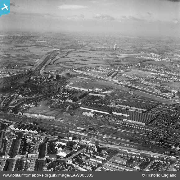
EAW003335 ENGLAND (1946). The Great Western Railway Works and environs, Swindon, from the south-east, 1946
© Copyright OpenStreetMap contributors and licensed by the OpenStreetMap Foundation. 2025. Cartography is licensed as CC BY-SA.
Nearby Images (6)
Details
| Title | [EAW003335] The Great Western Railway Works and environs, Swindon, from the south-east, 1946 |
| Reference | EAW003335 |
| Date | 13-November-1946 |
| Link | |
| Place name | SWINDON |
| Parish | |
| District | |
| Country | ENGLAND |
| Easting / Northing | 414925, 185245 |
| Longitude / Latitude | -1.7846526863651, 51.56540678566 |
| National Grid Reference | SU149852 |
Pins
 Gary |
Tuesday 16th of January 2024 05:32:23 PM | |
 Gary |
Tuesday 16th of January 2024 05:32:05 PM | |
 gBr |
Saturday 3rd of June 2017 05:12:11 PM | |
 gBr |
Saturday 3rd of June 2017 05:08:21 PM | |
 Gerald Maull |
Friday 1st of August 2014 04:21:04 PM | |
 Gerald Maull |
Friday 1st of August 2014 04:19:31 PM | |
 Gerald Maull |
Friday 1st of August 2014 04:16:42 PM | |
 Gerald Maull |
Friday 1st of August 2014 02:32:07 PM | |
 Class31 |
Tuesday 14th of January 2014 11:14:09 AM | |
 Class31 |
Tuesday 14th of January 2014 11:12:10 AM | |
 Class31 |
Tuesday 14th of January 2014 11:07:26 AM |


![[EAW003335] The Great Western Railway Works and environs, Swindon, from the south-east, 1946](http://britainfromabove.org.uk/sites/all/libraries/aerofilms-images/public/100x100/EAW/003/EAW003335.jpg)
![[EAW003323] The Great Western Railway Works and environs, Swindon, from the north-east, 1946](http://britainfromabove.org.uk/sites/all/libraries/aerofilms-images/public/100x100/EAW/003/EAW003323.jpg)
![[EAW003326] The Great Western Railway Works and environs, Swindon, from the north-east, 1946](http://britainfromabove.org.uk/sites/all/libraries/aerofilms-images/public/100x100/EAW/003/EAW003326.jpg)
![[EAW003324] The Great Western Railway Works and environs, Swindon, from the north-east, 1946](http://britainfromabove.org.uk/sites/all/libraries/aerofilms-images/public/100x100/EAW/003/EAW003324.jpg)
![[EAW053783] The Railway Works, Swindon, 1954](http://britainfromabove.org.uk/sites/all/libraries/aerofilms-images/public/100x100/EAW/053/EAW053783.jpg)
![[EPW059047] The Great Western Railway Works, Swindon, from the east, 1938](http://britainfromabove.org.uk/sites/all/libraries/aerofilms-images/public/100x100/EPW/059/EPW059047.jpg)