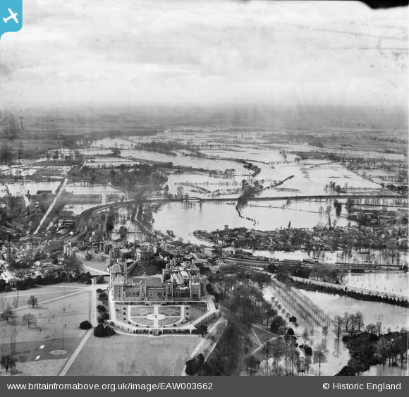
EAW003662 ENGLAND (1947). Flooding at Windsor and Eton, Windsor, from the east, 1947
© Copyright OpenStreetMap contributors and licensed by the OpenStreetMap Foundation. 2025. Cartography is licensed as CC BY-SA.
Nearby Images (29)
Details
| Title | [EAW003662] Flooding at Windsor and Eton, Windsor, from the east, 1947 |
| Reference | EAW003662 |
| Date | March-1947 |
| Link | |
| Place name | WINDSOR |
| Parish | |
| District | |
| Country | ENGLAND |
| Easting / Northing | 496849, 177215 |
| Longitude / Latitude | -0.60502752171822, 51.485098623211 |
| National Grid Reference | SU968772 |
Pins
 cptpies |
Friday 2nd of March 2018 10:11:33 AM | |
 Alan McFaden |
Sunday 12th of January 2014 08:07:05 PM | |
 dave43 |
Monday 9th of September 2013 09:51:27 PM | |
 dave43 |
Monday 9th of September 2013 09:50:32 PM |


![[EAW003662] Flooding at Windsor and Eton, Windsor, from the east, 1947](http://britainfromabove.org.uk/sites/all/libraries/aerofilms-images/public/100x100/EAW/003/EAW003662.jpg)
![[EAW042132] Windsor Castle and the town in the snow, Windsor, from the north-west, 1952](http://britainfromabove.org.uk/sites/all/libraries/aerofilms-images/public/100x100/EAW/042/EAW042132.jpg)
![[EPW012471] Windsor Castle, Windsor, 1925. This image has been produced from a print.](http://britainfromabove.org.uk/sites/all/libraries/aerofilms-images/public/100x100/EPW/012/EPW012471.jpg)
![[EAW053000] Windsor Castle, Windsor, 1953](http://britainfromabove.org.uk/sites/all/libraries/aerofilms-images/public/100x100/EAW/053/EAW053000.jpg)
![[EAW026473] Windsor Bridge and the town, Eton, 1949](http://britainfromabove.org.uk/sites/all/libraries/aerofilms-images/public/100x100/EAW/026/EAW026473.jpg)
![[EAW052997] Windsor Castle, Windsor, 1953](http://britainfromabove.org.uk/sites/all/libraries/aerofilms-images/public/100x100/EAW/052/EAW052997.jpg)
![[EPW053885] Windsor Castle, Windsor, 1937](http://britainfromabove.org.uk/sites/all/libraries/aerofilms-images/public/100x100/EPW/053/EPW053885.jpg)
![[EPW005694] Windsor Castle, Windsor, 1921. This image has been produced from a copy-negative.](http://britainfromabove.org.uk/sites/all/libraries/aerofilms-images/public/100x100/EPW/005/EPW005694.jpg)
![[EPW022596] Windsor Castle and The Home Park, Windsor, from the west, 1928](http://britainfromabove.org.uk/sites/all/libraries/aerofilms-images/public/100x100/EPW/022/EPW022596.jpg)
![[EAW003663] Flooding at Windsor and Eton, Windsor, from the south-east, 1947](http://britainfromabove.org.uk/sites/all/libraries/aerofilms-images/public/100x100/EAW/003/EAW003663.jpg)
![[EPW034876] Windsor Castle and the railway station, Windsor, 1931](http://britainfromabove.org.uk/sites/all/libraries/aerofilms-images/public/100x100/EPW/034/EPW034876.jpg)
![[EAW004841] Windsor Castle and St George's Chapel, Windsor, 1947](http://britainfromabove.org.uk/sites/all/libraries/aerofilms-images/public/100x100/EAW/004/EAW004841.jpg)
![[EPW005691] Windsor Castle, Windsor, 1921](http://britainfromabove.org.uk/sites/all/libraries/aerofilms-images/public/100x100/EPW/005/EPW005691.jpg)
![[EPW034874] Windsor Castle, Windsor, 1931](http://britainfromabove.org.uk/sites/all/libraries/aerofilms-images/public/100x100/EPW/034/EPW034874.jpg)
![[EPW053887] Windsor Castle and the town, Windsor, from the north-east, 1937](http://britainfromabove.org.uk/sites/all/libraries/aerofilms-images/public/100x100/EPW/053/EPW053887.jpg)
![[EPW001599] The Castle overlooking the Railway Station, Alexandra Gardens and the River Thames, Windsor, 1920. This image has been produced from a copy-negative.](http://britainfromabove.org.uk/sites/all/libraries/aerofilms-images/public/100x100/EPW/001/EPW001599.jpg)
![[EAW026474] Windsor Castle, Windsor, 1949](http://britainfromabove.org.uk/sites/all/libraries/aerofilms-images/public/100x100/EAW/026/EAW026474.jpg)
![[EPW056592] Windsor Castle, Windsor, 1938. This image has been produced from a copy-negative.](http://britainfromabove.org.uk/sites/all/libraries/aerofilms-images/public/100x100/EPW/056/EPW056592.jpg)
![[EAW004843] Windsor Castle, Windsor, 1947](http://britainfromabove.org.uk/sites/all/libraries/aerofilms-images/public/100x100/EAW/004/EAW004843.jpg)
![[EPW047391] Windsor Castle, the town and surrounding countryside, Windsor, from the west, 1935](http://britainfromabove.org.uk/sites/all/libraries/aerofilms-images/public/100x100/EPW/047/EPW047391.jpg)
![[EAW004842] Windsor Castle and St George's Chapel, Windsor, 1947](http://britainfromabove.org.uk/sites/all/libraries/aerofilms-images/public/100x100/EAW/004/EAW004842.jpg)
![[EPW056589] The River Thames at Eton Bridge and the town, Eton, 1938. This image has been produced from a copy-negative.](http://britainfromabove.org.uk/sites/all/libraries/aerofilms-images/public/100x100/EPW/056/EPW056589.jpg)
![[EPW056591] The Castle, Windsor, 1938](http://britainfromabove.org.uk/sites/all/libraries/aerofilms-images/public/100x100/EPW/056/EPW056591.jpg)
![[EPW046521] Windsor Castle and the town, Windsor, 1935](http://britainfromabove.org.uk/sites/all/libraries/aerofilms-images/public/100x100/EPW/046/EPW046521.jpg)
![[EAW004840] Windsor Castle and the East Terrace Garden, Windsor, 1947](http://britainfromabove.org.uk/sites/all/libraries/aerofilms-images/public/100x100/EAW/004/EAW004840.jpg)
![[EPW053886] Windsor Castle and the town, Windsor, from the north-east, 1937](http://britainfromabove.org.uk/sites/all/libraries/aerofilms-images/public/100x100/EPW/053/EPW053886.jpg)
![[EPW034873] Windsor Castle and the East Terrace Garden, Windsor, 1931](http://britainfromabove.org.uk/sites/all/libraries/aerofilms-images/public/100x100/EPW/034/EPW034873.jpg)
![[EPW046520] Windsor Castle, the East Terrace Garden and the town, Windsor, 1935](http://britainfromabove.org.uk/sites/all/libraries/aerofilms-images/public/100x100/EPW/046/EPW046520.jpg)
![[EPW046517] Windsor Castle, The Long Walk and the town, Windsor, 1935](http://britainfromabove.org.uk/sites/all/libraries/aerofilms-images/public/100x100/EPW/046/EPW046517.jpg)
