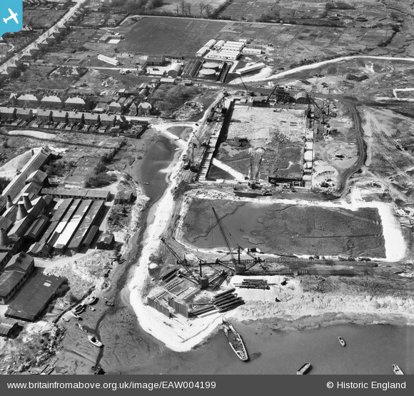
EAW004199 ENGLAND (1947). Land reclamation at the site of Hamworthy Power Station, Poole, 1947
© Copyright OpenStreetMap contributors and licensed by the OpenStreetMap Foundation. 2025. Cartography is licensed as CC BY-SA.
Nearby Images (26)
Details
| Title | [EAW004199] Land reclamation at the site of Hamworthy Power Station, Poole, 1947 |
| Reference | EAW004199 |
| Date | 10-April-1947 |
| Link | |
| Place name | POOLE |
| Parish | |
| District | |
| Country | ENGLAND |
| Easting / Northing | 400344, 90534 |
| Longitude / Latitude | -1.9951270329354, 50.713862382871 |
| National Grid Reference | SZ003905 |
Pins
 redmist |
Sunday 9th of August 2020 11:41:36 AM | |
 redmist |
Sunday 9th of August 2020 10:30:50 AM | |
 redmist |
Sunday 9th of August 2020 10:29:55 AM | |
 Graham Yaxley |
Wednesday 17th of December 2014 04:30:28 PM |


![[EAW004199] Land reclamation at the site of Hamworthy Power Station, Poole, 1947](http://britainfromabove.org.uk/sites/all/libraries/aerofilms-images/public/100x100/EAW/004/EAW004199.jpg)
![[EAW004195] Land reclamation at the site of Hamworthy Power Station, Poole, 1947](http://britainfromabove.org.uk/sites/all/libraries/aerofilms-images/public/100x100/EAW/004/EAW004195.jpg)
![[EAW019944] Holes Bay and construction of the Hamworthy Power Station, Lower Hamworthy, from the south-west, 1948. This image has been produced from a damaged negative.](http://britainfromabove.org.uk/sites/all/libraries/aerofilms-images/public/100x100/EAW/019/EAW019944.jpg)
![[EAW004197] Land reclamation at the site of Hamworthy Power Station, Poole, 1947](http://britainfromabove.org.uk/sites/all/libraries/aerofilms-images/public/100x100/EAW/004/EAW004197.jpg)
![[EAW019951] Construction of the Hamworthy Power Station, Lower Hamworthy, 1948. This image has been produced from a print marked by Aerofilms Ltd for photo editing.](http://britainfromabove.org.uk/sites/all/libraries/aerofilms-images/public/100x100/EAW/019/EAW019951.jpg)
![[EAW004194] Land reclamation at the site of Hamworthy Power Station, Poole, 1947](http://britainfromabove.org.uk/sites/all/libraries/aerofilms-images/public/100x100/EAW/004/EAW004194.jpg)
![[EAW019949] Construction of the Hamworthy Power Station, Lower Hamworthy, 1948. This image has been produced from a print.](http://britainfromabove.org.uk/sites/all/libraries/aerofilms-images/public/100x100/EAW/019/EAW019949.jpg)
![[EAW019953] Construction of the Hamworthy Power Station, Lower Hamworthy, 1948. This image has been produced from a print marked by Aerofilms Ltd for photo editing.](http://britainfromabove.org.uk/sites/all/libraries/aerofilms-images/public/100x100/EAW/019/EAW019953.jpg)
![[EAW004196] Land reclamation at the site of Hamworthy Power Station, Poole, 1947](http://britainfromabove.org.uk/sites/all/libraries/aerofilms-images/public/100x100/EAW/004/EAW004196.jpg)
![[EAW004201] Land reclamation at the site of Hamworthy Power Station, Poole, 1947](http://britainfromabove.org.uk/sites/all/libraries/aerofilms-images/public/100x100/EAW/004/EAW004201.jpg)
![[EAW019947] Construction of the Hamworthy Power Station, Lower Hamworthy, 1948. This image has been produced from a damaged negative.](http://britainfromabove.org.uk/sites/all/libraries/aerofilms-images/public/100x100/EAW/019/EAW019947.jpg)
![[EAW004206] Land reclamation at the site of Hamworthy Power Station, Poole, 1947](http://britainfromabove.org.uk/sites/all/libraries/aerofilms-images/public/100x100/EAW/004/EAW004206.jpg)
![[EAW019950] Construction of the Hamworthy Power Station and Holes Bay, Lower Hamworthy, from the south-west, 1948. This image has been produced from a print.](http://britainfromabove.org.uk/sites/all/libraries/aerofilms-images/public/100x100/EAW/019/EAW019950.jpg)
![[EAW019946] Construction of the Hamworthy Power Station, Lower Hamworthy, from the south-west, 1948. This image has been produced from a damaged negative.](http://britainfromabove.org.uk/sites/all/libraries/aerofilms-images/public/100x100/EAW/019/EAW019946.jpg)
![[EAW004200] Land reclamation at the site of Hamworthy Power Station, Poole, 1947](http://britainfromabove.org.uk/sites/all/libraries/aerofilms-images/public/100x100/EAW/004/EAW004200.jpg)
![[EAW004198] Land reclamation at the site of Hamworthy Power Station, Poole, 1947](http://britainfromabove.org.uk/sites/all/libraries/aerofilms-images/public/100x100/EAW/004/EAW004198.jpg)
![[EAW019948] Construction of the Hamworthy Power Station, Lower Hamworthy, from the north-west, 1948. This image has been produced from a print.](http://britainfromabove.org.uk/sites/all/libraries/aerofilms-images/public/100x100/EAW/019/EAW019948.jpg)
![[EAW004209] Land reclamation at the site of Hamworthy Power Station, Poole, 1947](http://britainfromabove.org.uk/sites/all/libraries/aerofilms-images/public/100x100/EAW/004/EAW004209.jpg)
![[EAW019954] Holes Bay and construction of the Hamworthy Power Station, Lower Hamworthy, from the south-west, 1948. This image was marked by Aerofilms Ltd for photo editing.](http://britainfromabove.org.uk/sites/all/libraries/aerofilms-images/public/100x100/EAW/019/EAW019954.jpg)
![[EAW004205] Land reclamation at the site of Hamworthy Power Station, Poole, from the south-west, 1947](http://britainfromabove.org.uk/sites/all/libraries/aerofilms-images/public/100x100/EAW/004/EAW004205.jpg)
![[EAW019952] Construction of the Hamworthy Power Station, Lower Hamworthy, from the north-east, 1948. This image has been produced from a print marked by Aerofilms Ltd for photo editing.](http://britainfromabove.org.uk/sites/all/libraries/aerofilms-images/public/100x100/EAW/019/EAW019952.jpg)
![[EAW004208] Land reclamation at the site of Hamworthy Power Station, Poole, from the west, 1947](http://britainfromabove.org.uk/sites/all/libraries/aerofilms-images/public/100x100/EAW/004/EAW004208.jpg)
![[EAW019945] Construction of the Hamworthy Power Station, Lower Hamworthy, from the north-west, 1948. This image has been produced from a damaged negative.](http://britainfromabove.org.uk/sites/all/libraries/aerofilms-images/public/100x100/EAW/019/EAW019945.jpg)
![[EAW004207] Land reclamation at the site of Hamworthy Power Station, Poole, from the west, 1947](http://britainfromabove.org.uk/sites/all/libraries/aerofilms-images/public/100x100/EAW/004/EAW004207.jpg)
![[EPW013631] The Pottery Works and Timber Yard off Hamworthy Road and Poole Bridge under construction, Poole, 1925. This image has been produced from a copy-negative.](http://britainfromabove.org.uk/sites/all/libraries/aerofilms-images/public/100x100/EPW/013/EPW013631.jpg)
![[EAW019955] Construction of the Hamworthy Power Station looking towards Poole, Lower Hamworthy, from the west, 1948. This image has been produced from a print marked by Aerofilms Ltd for photo editing.](http://britainfromabove.org.uk/sites/all/libraries/aerofilms-images/public/100x100/EAW/019/EAW019955.jpg)