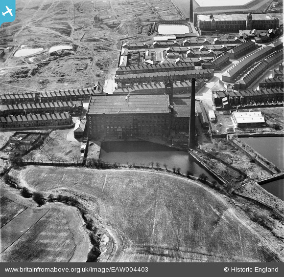
EAW004403 ENGLAND (1947). Honeywell Cotton Mill in Hathershaw, Oldham, 1947
© Copyright OpenStreetMap contributors and licensed by the OpenStreetMap Foundation. 2024. Cartography is licensed as CC BY-SA.
Nearby Images (8)
Details
| Title | [EAW004403] Honeywell Cotton Mill in Hathershaw, Oldham, 1947 |
| Reference | EAW004403 |
| Date | 13-April-1947 |
| Link | |
| Place name | OLDHAM |
| Parish | |
| District | |
| Country | ENGLAND |
| Easting / Northing | 392848, 402995 |
| Longitude / Latitude | -2.1078900762356, 53.523326692331 |
| National Grid Reference | SD928030 |
Pins
 stigansven |
Friday 7th of November 2014 03:08:27 PM | |
 stigansven |
Friday 7th of November 2014 03:06:15 PM | |
 Keith |
Friday 24th of January 2014 03:51:49 PM | |
 Keith |
Friday 24th of January 2014 03:51:17 PM | |
 Keith |
Friday 24th of January 2014 03:49:19 PM | |
 Keith |
Friday 24th of January 2014 03:48:43 PM | |
 eddief |
Friday 4th of October 2013 07:50:03 PM | |
 eddief |
Friday 4th of October 2013 05:43:48 PM | |
 eddief |
Friday 4th of October 2013 12:54:42 PM | |
 eddief |
Friday 4th of October 2013 12:50:38 PM | |
 eddief |
Friday 4th of October 2013 12:49:06 PM | |
 eddief |
Friday 4th of October 2013 12:48:22 PM |


![[EAW004403] Honeywell Cotton Mill in Hathershaw, Oldham, 1947](http://britainfromabove.org.uk/sites/all/libraries/aerofilms-images/public/100x100/EAW/004/EAW004403.jpg)
![[EAW004402] Honeywell Cotton Mill in Hathershaw, Oldham, 1947. This image has been produced from a print.](http://britainfromabove.org.uk/sites/all/libraries/aerofilms-images/public/100x100/EAW/004/EAW004402.jpg)
![[EAW004401] Honeywell Cotton Mill in Hathershaw, Oldham, 1947. This image was marked by Aerofilms Ltd for photo editing.](http://britainfromabove.org.uk/sites/all/libraries/aerofilms-images/public/100x100/EAW/004/EAW004401.jpg)
![[EAW004400] Honeywell Cotton Mill in Hathershaw, Oldham, 1947. This image was marked by Aerofilms Ltd for photo editing.](http://britainfromabove.org.uk/sites/all/libraries/aerofilms-images/public/100x100/EAW/004/EAW004400.jpg)
![[EAW004399] Honeywell Cotton Mill in Hathershaw, Oldham, 1947](http://britainfromabove.org.uk/sites/all/libraries/aerofilms-images/public/100x100/EAW/004/EAW004399.jpg)
![[EAW004406] Honeywell Cotton Mill in Hathershaw, Oldham, 1947. This image was marked by Aerofilms Ltd for photo editing.](http://britainfromabove.org.uk/sites/all/libraries/aerofilms-images/public/100x100/EAW/004/EAW004406.jpg)
![[EAW004405] Honeywell Cotton Mill in Hathershaw, Oldham, 1947. This image was marked by Aerofilms Ltd for photo editing.](http://britainfromabove.org.uk/sites/all/libraries/aerofilms-images/public/100x100/EAW/004/EAW004405.jpg)
![[EAW004404] Honeywell Cotton Mill in Hathershaw, Oldham, 1947](http://britainfromabove.org.uk/sites/all/libraries/aerofilms-images/public/100x100/EAW/004/EAW004404.jpg)