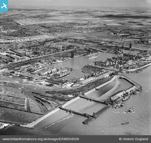
EAW004506 ENGLAND (1947). Alexandra Dock and environs, Kingston upon Hull, from the south-west, 1947
© Copyright OpenStreetMap contributors and licensed by the OpenStreetMap Foundation. 2025. Cartography is licensed as CC BY-SA.
Nearby Images (9)
Details
| Title | [EAW004506] Alexandra Dock and environs, Kingston upon Hull, from the south-west, 1947 |
| Reference | EAW004506 |
| Date | 16-April-1947 |
| Link | |
| Place name | KINGSTON UPON HULL |
| Parish | |
| District | |
| Country | ENGLAND |
| Easting / Northing | 511964, 428605 |
| Longitude / Latitude | -0.30217676226607, 53.741564286613 |
| National Grid Reference | TA120286 |
Pins
 redmist |
Sunday 24th of October 2021 11:46:03 AM | |
 redmist |
Sunday 24th of October 2021 11:39:10 AM | |
 redmist |
Sunday 24th of October 2021 11:37:54 AM | |
 redmist |
Sunday 24th of October 2021 11:35:59 AM | |
 redmist |
Sunday 24th of October 2021 11:27:46 AM | |
 redmist |
Sunday 24th of October 2021 11:26:15 AM | |
 redmist |
Sunday 24th of October 2021 11:22:00 AM | |
 redmist |
Sunday 24th of October 2021 11:19:57 AM | |
 redmist |
Sunday 24th of October 2021 11:19:25 AM | |
 redmist |
Sunday 24th of October 2021 11:18:52 AM | |
 redmist |
Sunday 24th of October 2021 11:18:25 AM | |
 redmist |
Sunday 24th of October 2021 11:17:44 AM | |
 redmist |
Friday 11th of January 2019 11:12:13 AM | |
 redmist |
Friday 11th of January 2019 11:10:45 AM | |
 Chris Kolonko |
Tuesday 17th of July 2018 12:56:49 PM | |
 Chris Kolonko |
Tuesday 17th of July 2018 12:56:34 PM | |
 Chris Kolonko |
Tuesday 17th of July 2018 12:56:04 PM | |
 Chris Kolonko |
Tuesday 17th of July 2018 12:55:07 PM | |
 redmist |
Tuesday 10th of October 2017 08:47:43 PM | |
 redmist |
Thursday 10th of November 2016 10:32:36 PM |


![[EAW004506] Alexandra Dock and environs, Kingston upon Hull, from the south-west, 1947](http://britainfromabove.org.uk/sites/all/libraries/aerofilms-images/public/100x100/EAW/004/EAW004506.jpg)
![[EPW036386] The West Wharf and environs, Kingston upon Hull, from the south-east, 1931](http://britainfromabove.org.uk/sites/all/libraries/aerofilms-images/public/100x100/EPW/036/EPW036386.jpg)
![[EPW010812] Alexandra Dock, Kingston upon Hull, from the south-west, 1924](http://britainfromabove.org.uk/sites/all/libraries/aerofilms-images/public/100x100/EPW/010/EPW010812.jpg)
![[EPW036554] West Wharf and Alexandra Dock, Kingston upon Hull, 1931](http://britainfromabove.org.uk/sites/all/libraries/aerofilms-images/public/100x100/EPW/036/EPW036554.jpg)
![[EPW036407] Boats moored at the West Wharf, the East Wharf and environs, Kingston upon Hull, from the south-west, 1931](http://britainfromabove.org.uk/sites/all/libraries/aerofilms-images/public/100x100/EPW/036/EPW036407.jpg)
![[EPW010808] Alexandra Dock, Kingston upon Hull, from the south-west, 1924](http://britainfromabove.org.uk/sites/all/libraries/aerofilms-images/public/100x100/EPW/010/EPW010808.jpg)
![[EPW036527] Alexandra Dock, West Wharf and the city, Kingston upon Hull, from the south-east, 1931](http://britainfromabove.org.uk/sites/all/libraries/aerofilms-images/public/100x100/EPW/036/EPW036527.jpg)
![[EPW036392] Boats moored in Alexandra Dock and environs, Kingston upon Hull, from the south-west, 1931](http://britainfromabove.org.uk/sites/all/libraries/aerofilms-images/public/100x100/EPW/036/EPW036392.jpg)
![[EPW036396] The West Wharf, Earle's Shipbuilding and Engineering Yard and Victoria Dock, Kingston upon Hull, from the south-east, 1931](http://britainfromabove.org.uk/sites/all/libraries/aerofilms-images/public/100x100/EPW/036/EPW036396.jpg)