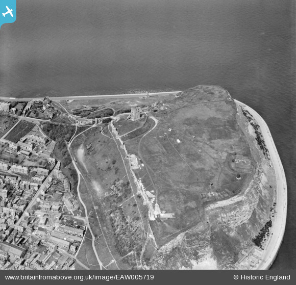
EAW005719 ENGLAND (1947). Scarborough Castle, Scarborough, 1947
© Copyright OpenStreetMap contributors and licensed by the OpenStreetMap Foundation. 2024. Cartography is licensed as CC BY-SA.
Nearby Images (15)
Details
| Title | [EAW005719] Scarborough Castle, Scarborough, 1947 |
| Reference | EAW005719 |
| Date | 15-May-1947 |
| Link | |
| Place name | SCARBOROUGH |
| Parish | |
| District | |
| Country | ENGLAND |
| Easting / Northing | 504986, 489147 |
| Longitude / Latitude | -0.38703494129042, 54.286996341677 |
| National Grid Reference | TA050891 |
Pins
 redmist |
Friday 13th of September 2019 09:40:35 AM | |
 redmist |
Friday 13th of September 2019 09:39:34 AM | |
 The Laird |
Sunday 22nd of March 2015 12:02:07 PM |


![[EAW005719] Scarborough Castle, Scarborough, 1947](http://britainfromabove.org.uk/sites/all/libraries/aerofilms-images/public/100x100/EAW/005/EAW005719.jpg)
![[EAW005718] Scarborough Castle, Scarborough, 1947. This image has been produced from a print.](http://britainfromabove.org.uk/sites/all/libraries/aerofilms-images/public/100x100/EAW/005/EAW005718.jpg)
![[EPW029093] Scarborough Castle, Scarborough, 1929](http://britainfromabove.org.uk/sites/all/libraries/aerofilms-images/public/100x100/EPW/029/EPW029093.jpg)
![[EAW005717] Scarborough Castle and South Sands, Scarborough, 1947. This image has been produced from a print.](http://britainfromabove.org.uk/sites/all/libraries/aerofilms-images/public/100x100/EAW/005/EAW005717.jpg)
![[EAW005722] Scarborough Castle, Scarborough, 1947](http://britainfromabove.org.uk/sites/all/libraries/aerofilms-images/public/100x100/EAW/005/EAW005722.jpg)
![[EAW005721] Scarborough Castle, Scarborough, 1947](http://britainfromabove.org.uk/sites/all/libraries/aerofilms-images/public/100x100/EAW/005/EAW005721.jpg)
![[EAW005716] Scarborough Castle and St Mary's Church, Scarborough, 1947. This image has been produced from a print.](http://britainfromabove.org.uk/sites/all/libraries/aerofilms-images/public/100x100/EAW/005/EAW005716.jpg)
![[EAW016697] Castle Hill and South Bay, Scarborough, 1948](http://britainfromabove.org.uk/sites/all/libraries/aerofilms-images/public/100x100/EAW/016/EAW016697.jpg)
![[EAW016699] Scarborough Castle, Scarborough, 1948](http://britainfromabove.org.uk/sites/all/libraries/aerofilms-images/public/100x100/EAW/016/EAW016699.jpg)
![[EAW005720] Scarborough Castle, Scarborough, 1947. This image has been produced from a print.](http://britainfromabove.org.uk/sites/all/libraries/aerofilms-images/public/100x100/EAW/005/EAW005720.jpg)
![[EAW016695] Scarborough Castle and The Holms, Scarborough, 1948](http://britainfromabove.org.uk/sites/all/libraries/aerofilms-images/public/100x100/EAW/016/EAW016695.jpg)
![[EAW007949] The castle and South Bay, Scarborough, from the north, 1947](http://britainfromabove.org.uk/sites/all/libraries/aerofilms-images/public/100x100/EAW/007/EAW007949.jpg)
![[EAW016696] Scarborough Castle and The Holms, Scarborough, 1948](http://britainfromabove.org.uk/sites/all/libraries/aerofilms-images/public/100x100/EAW/016/EAW016696.jpg)
![[EAW007950] The castle and South Bay, Scarborough, from the north, 1947](http://britainfromabove.org.uk/sites/all/libraries/aerofilms-images/public/100x100/EAW/007/EAW007950.jpg)
![[EAW016698] Castle Hill and the town, Scarborough, 1948](http://britainfromabove.org.uk/sites/all/libraries/aerofilms-images/public/100x100/EAW/016/EAW016698.jpg)