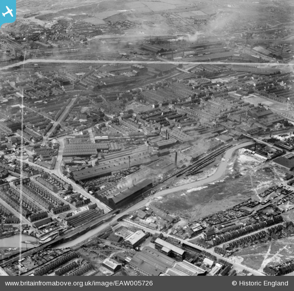
EAW005726 ENGLAND (1947). The Brown Bayleys Steel Works and the surrounding residential area, Sheffield, 1947. This image was marked by Aerofilms Ltd for photo editing.
© Copyright OpenStreetMap contributors and licensed by the OpenStreetMap Foundation. 2024. Cartography is licensed as CC BY-SA.
Nearby Images (13)
Details
| Title | [EAW005726] The Brown Bayleys Steel Works and the surrounding residential area, Sheffield, 1947. This image was marked by Aerofilms Ltd for photo editing. |
| Reference | EAW005726 |
| Date | 15-May-1947 |
| Link | |
| Place name | SHEFFIELD |
| Parish | |
| District | |
| Country | ENGLAND |
| Easting / Northing | 438304, 389060 |
| Longitude / Latitude | -1.423886333744, 53.396716615415 |
| National Grid Reference | SK383891 |
Pins
 circloy |
Thursday 11th of April 2024 01:48:11 AM | |
 circloy |
Thursday 11th of April 2024 01:44:36 AM | |
 circloy |
Thursday 11th of April 2024 01:41:59 AM | |
 cat631 |
Sunday 2nd of July 2017 01:47:50 AM | |
 cat631 |
Sunday 2nd of July 2017 01:47:38 AM | |
 cat631 |
Sunday 2nd of July 2017 01:47:36 AM | |
 cat631 |
Sunday 2nd of July 2017 01:46:05 AM | |
 cat631 |
Sunday 2nd of July 2017 01:39:09 AM | |
 cat631 |
Sunday 2nd of July 2017 01:34:40 AM | |
 Class31 |
Tuesday 21st of July 2015 04:36:14 PM | |
 Class31 |
Tuesday 21st of July 2015 04:33:09 PM | |
 Class31 |
Tuesday 21st of July 2015 04:31:51 PM | |
 Class31 |
Tuesday 21st of July 2015 04:26:29 PM | |
 circloy |
Sunday 12th of October 2014 07:34:56 PM | |
 circloy |
Sunday 12th of October 2014 07:33:38 PM |


![[EAW005726] The Brown Bayleys Steel Works and the surrounding residential area, Sheffield, 1947. This image was marked by Aerofilms Ltd for photo editing.](http://britainfromabove.org.uk/sites/all/libraries/aerofilms-images/public/100x100/EAW/005/EAW005726.jpg)
![[EAW005724] The Brown Bayleys Steel Works and the surrounding residential area, Sheffield, 1947. This image was marked by Aerofilms Ltd for photo editing.](http://britainfromabove.org.uk/sites/all/libraries/aerofilms-images/public/100x100/EAW/005/EAW005724.jpg)
![[EAW005729] The Brown Bayleys Steel Works and the surrounding residential area, Sheffield, 1947. This image was marked by Aerofilms Ltd for photo editing.](http://britainfromabove.org.uk/sites/all/libraries/aerofilms-images/public/100x100/EAW/005/EAW005729.jpg)
![[EAW005728] The Brown Bayleys Steel Works and the surrounding residential area, Sheffield, 1947](http://britainfromabove.org.uk/sites/all/libraries/aerofilms-images/public/100x100/EAW/005/EAW005728.jpg)
![[EAW005732] The Brown Bayleys Steel Works and the surrounding area, Sheffield, 1947. This image was marked by Aerofilms Ltd for photo editing.](http://britainfromabove.org.uk/sites/all/libraries/aerofilms-images/public/100x100/EAW/005/EAW005732.jpg)
![[EAW005730] The Brown Bayleys Steel Works and the surrounding area, Sheffield, 1947. This image was marked by Aerofilms Ltd for photo editing.](http://britainfromabove.org.uk/sites/all/libraries/aerofilms-images/public/100x100/EAW/005/EAW005730.jpg)
![[EAW005731] The Brown Bayleys Steel Works and the surrounding area, Sheffield, 1947. This image was marked by Aerofilms Ltd for photo editing.](http://britainfromabove.org.uk/sites/all/libraries/aerofilms-images/public/100x100/EAW/005/EAW005731.jpg)
![[EAW005725] The Brown Bayleys Steel Works and the surrounding residential area, Sheffield, 1947. This image was marked by Aerofilms Ltd for photo editing.](http://britainfromabove.org.uk/sites/all/libraries/aerofilms-images/public/100x100/EAW/005/EAW005725.jpg)
![[EAW006266] Brown Bayley Steel Works and environs, Attercliffe, 1947. This image was marked by Aerofilms Ltd for photo editing.](http://britainfromabove.org.uk/sites/all/libraries/aerofilms-images/public/100x100/EAW/006/EAW006266.jpg)
![[EAW005723] The Brown Bayleys Steel Works and the surrounding residential area, Sheffield, 1947. This image was marked by Aerofilms Ltd for photo editing.](http://britainfromabove.org.uk/sites/all/libraries/aerofilms-images/public/100x100/EAW/005/EAW005723.jpg)
![[EAW006267] Brown Bayley Steel Works and environs, Attercliffe, 1947. This image was marked by Aerofilms Ltd for photo editing.](http://britainfromabove.org.uk/sites/all/libraries/aerofilms-images/public/100x100/EAW/006/EAW006267.jpg)
![[EAW006268] Brown Bayley Steel Works and environs, Attercliffe, 1947. This image was marked by Aerofilms Ltd for photo editing.](http://britainfromabove.org.uk/sites/all/libraries/aerofilms-images/public/100x100/EAW/006/EAW006268.jpg)
![[EAW006269] Brown Bayley Steel Works and environs, Attercliffe, 1947. This image was marked by Aerofilms Ltd for photo editing.](http://britainfromabove.org.uk/sites/all/libraries/aerofilms-images/public/100x100/EAW/006/EAW006269.jpg)