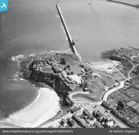
EAW006054 ENGLAND (1947). Tynemouth Castle and North Pier, Tynemouth, 1947
© Copyright OpenStreetMap contributors and licensed by the OpenStreetMap Foundation. 2025. Cartography is licensed as CC BY-SA.
Nearby Images (11)
Details
| Title | [EAW006054] Tynemouth Castle and North Pier, Tynemouth, 1947 |
| Reference | EAW006054 |
| Date | 21-May-1947 |
| Link | |
| Place name | TYNEMOUTH |
| Parish | |
| District | |
| Country | ENGLAND |
| Easting / Northing | 437347, 569380 |
| Longitude / Latitude | -1.4158519740206, 55.017492683679 |
| National Grid Reference | NZ373694 |
Pins
 redmist |
Friday 2nd of August 2019 08:30:25 PM | |
 redmist |
Thursday 1st of August 2019 10:02:32 AM | |
 redmist |
Thursday 1st of August 2019 10:01:21 AM | |
 redmist |
Thursday 1st of August 2019 09:59:39 AM | |
 redmist |
Thursday 1st of August 2019 09:57:16 AM | |
 redmist |
Thursday 1st of August 2019 09:55:45 AM | |
 redmist |
Thursday 1st of August 2019 09:54:31 AM | |
 cptpies |
Monday 8th of December 2014 12:55:00 PM | |
 cheviotwalks |
Tuesday 14th of October 2014 08:14:15 PM |


![[EAW006054] Tynemouth Castle and North Pier, Tynemouth, 1947](http://britainfromabove.org.uk/sites/all/libraries/aerofilms-images/public/100x100/EAW/006/EAW006054.jpg)
![[EAW006052] Tynemouth Castle, Tynemouth, 1947. This image has been produced from a copy-negative.](http://britainfromabove.org.uk/sites/all/libraries/aerofilms-images/public/100x100/EAW/006/EAW006052.jpg)
![[EPW019758] The castle and priory ruins, Tynemouth, 1927](http://britainfromabove.org.uk/sites/all/libraries/aerofilms-images/public/100x100/EPW/019/EPW019758.jpg)
![[EAW006050] Tynemouth Castle, Tynemouth, 1947. This image has been produced from a copy-negative.](http://britainfromabove.org.uk/sites/all/libraries/aerofilms-images/public/100x100/EAW/006/EAW006050.jpg)
![[EAW006051] Tynemouth Castle, Tynemouth, 1947. This image has been produced from a copy-negative.](http://britainfromabove.org.uk/sites/all/libraries/aerofilms-images/public/100x100/EAW/006/EAW006051.jpg)
![[EPW019754] The castle and priory ruins, Tynemouth, 1927](http://britainfromabove.org.uk/sites/all/libraries/aerofilms-images/public/100x100/EPW/019/EPW019754.jpg)
![[EAW006053] Tynemouth Castle, Tynemouth, 1947. This image has been produced from a copy-negative.](http://britainfromabove.org.uk/sites/all/libraries/aerofilms-images/public/100x100/EAW/006/EAW006053.jpg)
![[EPW040680] Tynemouth Castle, Tynemouth, 1932](http://britainfromabove.org.uk/sites/all/libraries/aerofilms-images/public/100x100/EPW/040/EPW040680.jpg)
![[EAW006055] Tynemouth Castle, Tynemouth, 1947](http://britainfromabove.org.uk/sites/all/libraries/aerofilms-images/public/100x100/EAW/006/EAW006055.jpg)
![[EPW040681] Tynemouth Castle and Prior's Haven, Tynemouth, 1932](http://britainfromabove.org.uk/sites/all/libraries/aerofilms-images/public/100x100/EPW/040/EPW040681.jpg)
![[EAW052310] The River Tyne, Tynemouth, from the north-east, 1953](http://britainfromabove.org.uk/sites/all/libraries/aerofilms-images/public/100x100/EAW/052/EAW052310.jpg)


