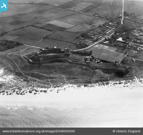
EAW006090 ENGLAND (1947). Bamburgh Castle and the Castle Green, Bamburgh, 1947. This image has been produced from a print.
© Copyright OpenStreetMap contributors and licensed by the OpenStreetMap Foundation. 2025. Cartography is licensed as CC BY-SA.
Nearby Images (12)
Details
| Title | [EAW006090] Bamburgh Castle and the Castle Green, Bamburgh, 1947. This image has been produced from a print. |
| Reference | EAW006090 |
| Date | 21-May-1947 |
| Link | |
| Place name | BAMBURGH |
| Parish | BAMBURGH |
| District | |
| Country | ENGLAND |
| Easting / Northing | 418338, 635148 |
| Longitude / Latitude | -1.7088691915812, 55.609589961515 |
| National Grid Reference | NU183351 |
Pins
 Matt Aldred edob.mattaldred.com |
Thursday 31st of December 2020 03:45:05 PM | |
 Matt Aldred edob.mattaldred.com |
Thursday 31st of December 2020 03:44:51 PM | |
 Matt Aldred edob.mattaldred.com |
Thursday 31st of December 2020 03:44:29 PM | |
 redmist |
Friday 7th of February 2020 12:24:08 PM | |
 redmist |
Friday 7th of February 2020 12:21:49 PM | |
 redmist |
Thursday 31st of October 2019 12:00:13 AM | |
 redmist |
Wednesday 30th of October 2019 11:59:46 PM | |
 redmist |
Wednesday 30th of October 2019 11:59:19 PM | |
 Mark P |
Tuesday 14th of November 2017 09:55:28 PM | |
 melgibbs |
Monday 11th of April 2016 04:52:46 PM | |
 melgibbs |
Friday 16th of October 2015 04:53:03 PM | |
 melgibbs |
Wednesday 22nd of October 2014 07:40:52 PM | |
 melgibbs |
Monday 6th of October 2014 06:14:35 PM | |
 melgibbs |
Monday 6th of October 2014 06:07:09 PM | |
 melgibbs |
Monday 6th of October 2014 06:06:04 PM | |
 melgibbs |
Monday 6th of October 2014 06:05:19 PM | |
 melgibbs |
Monday 6th of October 2014 06:04:08 PM | |
 melgibbs |
Monday 6th of October 2014 06:03:47 PM | |
 melgibbs |
Monday 6th of October 2014 01:30:52 PM |
User Comment Contributions
Shipwrecks were common on this stretch of coastline and a Dr John Sharp (1722 - 1792) who was resident at the castle founded what is recognised as the first coastguard system in the world. More can be read at http://bamburgh.org.uk/news/did-bamburgh-shipwreck-inspire-first-coastguards-/ and http://www.bamburghcastle.com/history_more.php?id=57 |
 melgibbs |
Sunday 30th of October 2016 06:45:36 PM |


![[EAW006090] Bamburgh Castle and the Castle Green, Bamburgh, 1947. This image has been produced from a print.](http://britainfromabove.org.uk/sites/all/libraries/aerofilms-images/public/100x100/EAW/006/EAW006090.jpg)
![[EAW006089] Bamburgh Castle and the Castle Green, Bamburgh, 1947. This image has been produced from a print.](http://britainfromabove.org.uk/sites/all/libraries/aerofilms-images/public/100x100/EAW/006/EAW006089.jpg)
![[EAW034345] Bamburgh Castle overlooking the village, Bamburgh, 1950. This image has been produced from a print.](http://britainfromabove.org.uk/sites/all/libraries/aerofilms-images/public/100x100/EAW/034/EAW034345.jpg)
![[EAW006093] Bamburgh Castle and the Castle Green, Bamburgh, 1947. This image has been produced from a print marked by Aerofilms Ltd for photo editing.](http://britainfromabove.org.uk/sites/all/libraries/aerofilms-images/public/100x100/EAW/006/EAW006093.jpg)
![[EAW034342] Bamburgh Castle and Castle Green, Bamburgh, 1950. This image has been produced from a print.](http://britainfromabove.org.uk/sites/all/libraries/aerofilms-images/public/100x100/EAW/034/EAW034342.jpg)
![[EAW034344] Bamburgh Castle, Bamburgh, 1950. This image has been produced from a print.](http://britainfromabove.org.uk/sites/all/libraries/aerofilms-images/public/100x100/EAW/034/EAW034344.jpg)
![[EAW006091] Bamburgh Castle and the Castle Green, Bamburgh, 1947. This image has been produced from a print marked by Aerofilms Ltd for photo editing.](http://britainfromabove.org.uk/sites/all/libraries/aerofilms-images/public/100x100/EAW/006/EAW006091.jpg)
![[EAW034343] Bamburgh Castle and Castle Green, Bamburgh, 1950. This image has been produced from a print.](http://britainfromabove.org.uk/sites/all/libraries/aerofilms-images/public/100x100/EAW/034/EAW034343.jpg)
![[EAW006088] Bamburgh Castle and the Castle Green, Bamburgh, from the south-west, 1947](http://britainfromabove.org.uk/sites/all/libraries/aerofilms-images/public/100x100/EAW/006/EAW006088.jpg)
![[EAW034346] Bamburgh Castle, Bamburgh, 1950. This image has been produced from a print.](http://britainfromabove.org.uk/sites/all/libraries/aerofilms-images/public/100x100/EAW/034/EAW034346.jpg)
![[EAW006092] Bamburgh Castle and the Castle Green, Bamburgh, 1947](http://britainfromabove.org.uk/sites/all/libraries/aerofilms-images/public/100x100/EAW/006/EAW006092.jpg)
![[EAW034347] Bamburgh Castle, Bamburgh, from the south, 1950. This image has been produced from a print.](http://britainfromabove.org.uk/sites/all/libraries/aerofilms-images/public/100x100/EAW/034/EAW034347.jpg)

