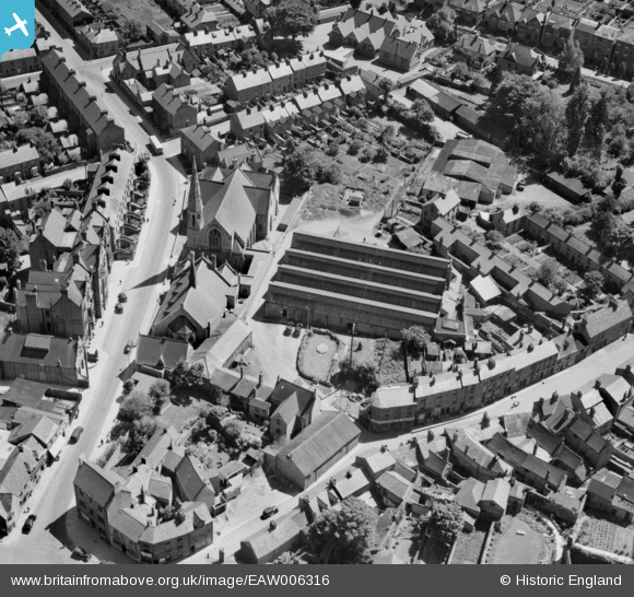
EAW006316 ENGLAND (1947). Cheney & Sons Ltd on Calthorpe Street and environs, Banbury, 1947
© Copyright OpenStreetMap contributors and licensed by the OpenStreetMap Foundation. 2025. Cartography is licensed as CC BY-SA.
Nearby Images (28)
Details
| Title | [EAW006316] Cheney & Sons Ltd on Calthorpe Street and environs, Banbury, 1947 |
| Reference | EAW006316 |
| Date | 27-May-1947 |
| Link | |
| Place name | BANBURY |
| Parish | BANBURY |
| District | |
| Country | ENGLAND |
| Easting / Northing | 445491, 240348 |
| Longitude / Latitude | -1.3364107823533, 52.05922387249 |
| National Grid Reference | SP455403 |
Pins
Be the first to add a comment to this image!


![[EAW006316] Cheney & Sons Ltd on Calthorpe Street and environs, Banbury, 1947](http://britainfromabove.org.uk/sites/all/libraries/aerofilms-images/public/100x100/EAW/006/EAW006316.jpg)
![[EAW006321] Cheney & Sons Ltd on Calthorpe Street and environs, Banbury, 1947](http://britainfromabove.org.uk/sites/all/libraries/aerofilms-images/public/100x100/EAW/006/EAW006321.jpg)
![[EAW006320] Cheney & Sons Ltd on Calthorpe Street and environs, Banbury, 1947](http://britainfromabove.org.uk/sites/all/libraries/aerofilms-images/public/100x100/EAW/006/EAW006320.jpg)
![[EAW006317] Cheney & Sons Ltd on Calthorpe Street and environs, Banbury, 1947](http://britainfromabove.org.uk/sites/all/libraries/aerofilms-images/public/100x100/EAW/006/EAW006317.jpg)
![[EAW006319] Cheney & Sons Ltd, the Wesleyan Methodist Chapel on Marlborough Road and environs, Banbury, 1947](http://britainfromabove.org.uk/sites/all/libraries/aerofilms-images/public/100x100/EAW/006/EAW006319.jpg)
![[EAW006318] Cheney & Sons Ltd on Calthorpe Street and environs, Banbury, 1947](http://britainfromabove.org.uk/sites/all/libraries/aerofilms-images/public/100x100/EAW/006/EAW006318.jpg)
![[EAW006315] Cheney & Sons Ltd on Calthorpe Street and environs, Banbury, 1947](http://britainfromabove.org.uk/sites/all/libraries/aerofilms-images/public/100x100/EAW/006/EAW006315.jpg)
![[EPW028257] High Street, Banbury, 1929. This image has been produced from a copy-negative.](http://britainfromabove.org.uk/sites/all/libraries/aerofilms-images/public/100x100/EPW/028/EPW028257.jpg)
![[EAW029563] Horse Fair and the town centre, Banbury, 1950](http://britainfromabove.org.uk/sites/all/libraries/aerofilms-images/public/100x100/EAW/029/EAW029563.jpg)
![[EAW006322] Banbury Cross and Horse Fair, Banbury, 1947](http://britainfromabove.org.uk/sites/all/libraries/aerofilms-images/public/100x100/EAW/006/EAW006322.jpg)
![[EPW028252] Horse Fair and the town centre, Banbury, 1929. This image has been produced from a copy-negative.](http://britainfromabove.org.uk/sites/all/libraries/aerofilms-images/public/100x100/EPW/028/EPW028252.jpg)
![[EPW006004] Banbury Cross and the town centre, Banbury, 1921. This image has been produced from a copy-negative.](http://britainfromabove.org.uk/sites/all/libraries/aerofilms-images/public/100x100/EPW/006/EPW006004.jpg)
![[EAW006314] Banbury Cross, Horse Fair and the town, Banbury, 1947](http://britainfromabove.org.uk/sites/all/libraries/aerofilms-images/public/100x100/EAW/006/EAW006314.jpg)
![[EAW029564] Horse Fair and the town centre, Banbury, 1950](http://britainfromabove.org.uk/sites/all/libraries/aerofilms-images/public/100x100/EAW/029/EAW029564.jpg)
![[EPW028256] Horse Fair, Banbury, 1929. This image has been produced from a copy-negative.](http://britainfromabove.org.uk/sites/all/libraries/aerofilms-images/public/100x100/EPW/028/EPW028256.jpg)
![[EPW028260] St John the Evangelist's R.C. Church and South Bar Street, Banbury, 1929](http://britainfromabove.org.uk/sites/all/libraries/aerofilms-images/public/100x100/EPW/028/EPW028260.jpg)
![[EPW010584] The Town Centre, Banbury, 1924](http://britainfromabove.org.uk/sites/all/libraries/aerofilms-images/public/100x100/EPW/010/EPW010584.jpg)
![[EPW028255] Horse Fair and the town centre, Banbury, 1929. This image has been produced from a copy-negative.](http://britainfromabove.org.uk/sites/all/libraries/aerofilms-images/public/100x100/EPW/028/EPW028255.jpg)
![[EAW006311] Bridge Street, the Market Place and town centre, Banbury, 1947](http://britainfromabove.org.uk/sites/all/libraries/aerofilms-images/public/100x100/EAW/006/EAW006311.jpg)
![[EPW028261] St John the Evangelist's R.C. Church and South Bar Street, Banbury, 1929](http://britainfromabove.org.uk/sites/all/libraries/aerofilms-images/public/100x100/EPW/028/EPW028261.jpg)
![[EAW006313] Banbury Cross, Horse Fair and the town, Banbury, 1947](http://britainfromabove.org.uk/sites/all/libraries/aerofilms-images/public/100x100/EAW/006/EAW006313.jpg)
![[EAW029562] The Spencer (Banbury) Ltd Surgical Appliance Factory, Banbury, 1950. This image was marked by Aerofilms Ltd for photo editing.](http://britainfromabove.org.uk/sites/all/libraries/aerofilms-images/public/100x100/EAW/029/EAW029562.jpg)
![[EAW029556] The Spencer (Banbury) Ltd Surgical Appliance Factory, Banbury, 1950. This image was marked by Aerofilms Ltd for photo editing.](http://britainfromabove.org.uk/sites/all/libraries/aerofilms-images/public/100x100/EAW/029/EAW029556.jpg)
![[EAW029561] The Spencer (Banbury) Ltd Surgical Appliance Factory, Banbury, 1950. This image was marked by Aerofilms Ltd for photo editing.](http://britainfromabove.org.uk/sites/all/libraries/aerofilms-images/public/100x100/EAW/029/EAW029561.jpg)
![[EAW029557] The Spencer (Banbury) Ltd Surgical Appliance Factory, Banbury, 1950. This image was marked by Aerofilms Ltd for photo editing.](http://britainfromabove.org.uk/sites/all/libraries/aerofilms-images/public/100x100/EAW/029/EAW029557.jpg)
![[EAW029559] The Spencer (Banbury) Ltd Surgical Appliance Factory, Banbury, 1950. This image was marked by Aerofilms Ltd for photo editing.](http://britainfromabove.org.uk/sites/all/libraries/aerofilms-images/public/100x100/EAW/029/EAW029559.jpg)
![[EAW029560] The Spencer (Banbury) Ltd Surgical Appliance Factory, Banbury, 1950. This image was marked by Aerofilms Ltd for photo editing.](http://britainfromabove.org.uk/sites/all/libraries/aerofilms-images/public/100x100/EAW/029/EAW029560.jpg)
![[EAW029558] The Spencer (Banbury) Ltd Surgical Appliance Factory and environs, Banbury, 1950. This image was marked by Aerofilms Ltd for photo editing.](http://britainfromabove.org.uk/sites/all/libraries/aerofilms-images/public/100x100/EAW/029/EAW029558.jpg)