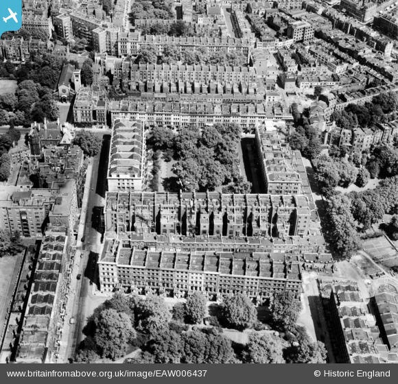
EAW006437 ENGLAND (1947). Ennismore Gardens and surrounding streets, Knightsbridge, 1947
© Copyright OpenStreetMap contributors and licensed by the OpenStreetMap Foundation. 2024. Cartography is licensed as CC BY-SA.
Nearby Images (14)
Details
| Title | [EAW006437] Ennismore Gardens and surrounding streets, Knightsbridge, 1947 |
| Reference | EAW006437 |
| Date | 2-June-1947 |
| Link | |
| Place name | KNIGHTSBRIDGE |
| Parish | |
| District | |
| Country | ENGLAND |
| Easting / Northing | 527066, 179425 |
| Longitude / Latitude | -0.1692092153879, 51.498979380139 |
| National Grid Reference | TQ271794 |
Pins
Be the first to add a comment to this image!


![[EAW006437] Ennismore Gardens and surrounding streets, Knightsbridge, 1947](http://britainfromabove.org.uk/sites/all/libraries/aerofilms-images/public/100x100/EAW/006/EAW006437.jpg)
![[EAW006440] Ennismore Gardens and surrounding streets, Knightsbridge, 1947](http://britainfromabove.org.uk/sites/all/libraries/aerofilms-images/public/100x100/EAW/006/EAW006440.jpg)
![[EAW006444] Ennismore Gardens and surrounding streets, Knightsbridge, 1947](http://britainfromabove.org.uk/sites/all/libraries/aerofilms-images/public/100x100/EAW/006/EAW006444.jpg)
![[EAW006443] Ennismore Gardens and surrounding streets, Knightsbridge, 1947](http://britainfromabove.org.uk/sites/all/libraries/aerofilms-images/public/100x100/EAW/006/EAW006443.jpg)
![[EAW006439] Ennismore Gardens and surrounding streets, Knightsbridge, 1947](http://britainfromabove.org.uk/sites/all/libraries/aerofilms-images/public/100x100/EAW/006/EAW006439.jpg)
![[EAW006445] Ennismore Gardens and surrounding streets, Knightsbridge, 1947](http://britainfromabove.org.uk/sites/all/libraries/aerofilms-images/public/100x100/EAW/006/EAW006445.jpg)
![[EAW006438] Ennismore Gardens and surrounding streets, Knightsbridge, 1947](http://britainfromabove.org.uk/sites/all/libraries/aerofilms-images/public/100x100/EAW/006/EAW006438.jpg)
![[EAW006442] Ennismore Gardens and surrounding streets, Knightsbridge, 1947](http://britainfromabove.org.uk/sites/all/libraries/aerofilms-images/public/100x100/EAW/006/EAW006442.jpg)
![[EAW006441] Ennismore Gardens and surrounding streets, Knightsbridge, 1947](http://britainfromabove.org.uk/sites/all/libraries/aerofilms-images/public/100x100/EAW/006/EAW006441.jpg)
![[EAW000554] Victoria and Albert Museum, Hyde Park and environs, Knightsbridge, 1946](http://britainfromabove.org.uk/sites/all/libraries/aerofilms-images/public/100x100/EAW/000/EAW000554.jpg)
![[EAW000556] Albertopolis, Knightsbridge, 1946](http://britainfromabove.org.uk/sites/all/libraries/aerofilms-images/public/100x100/EAW/000/EAW000556.jpg)
![[EPW010190] The Oratory, Brompton Square and environs, Brompton, 1924. This image has been produced from a print.](http://britainfromabove.org.uk/sites/all/libraries/aerofilms-images/public/100x100/EPW/010/EPW010190.jpg)
![[EAW015858] The Brompton Oratory, Victoria and Albert Museum and surrounding area of Albertopolis, Brompton, 1948](http://britainfromabove.org.uk/sites/all/libraries/aerofilms-images/public/100x100/EAW/015/EAW015858.jpg)
![[EPW036286] "Albertopolis", Knightsbridge, 1931](http://britainfromabove.org.uk/sites/all/libraries/aerofilms-images/public/100x100/EPW/036/EPW036286.jpg)