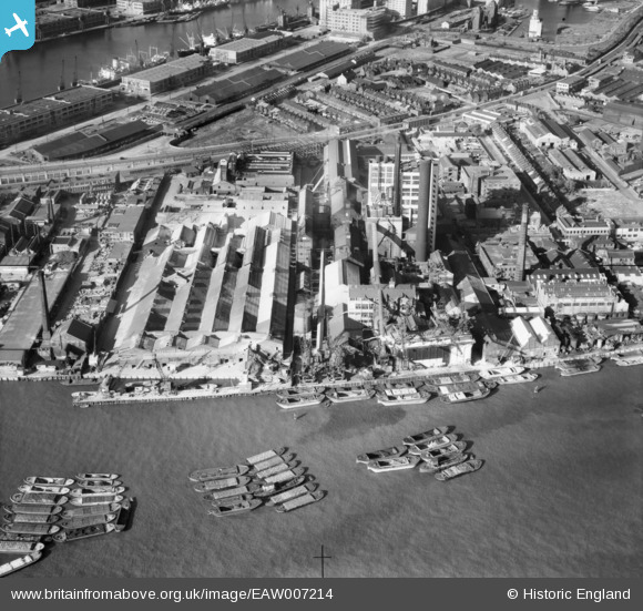
EAW007214 ENGLAND (1947). The Tate and Lyle Sugar Refinery, Silvertown, 1947
© Copyright OpenStreetMap contributors and licensed by the OpenStreetMap Foundation. 2025. Cartography is licensed as CC BY-SA.
Nearby Images (48)
Details
| Title | [EAW007214] The Tate and Lyle Sugar Refinery, Silvertown, 1947 |
| Reference | EAW007214 |
| Date | 24-June-1947 |
| Link | |
| Place name | SILVERTOWN |
| Parish | |
| District | |
| Country | ENGLAND |
| Easting / Northing | 540154, 179987 |
| Longitude / Latitude | 0.019468352969502, 51.500936071807 |
| National Grid Reference | TQ402800 |
Pins
 Dave |
Wednesday 4th of December 2013 12:36:45 PM |


![[EAW007214] The Tate and Lyle Sugar Refinery, Silvertown, 1947](http://britainfromabove.org.uk/sites/all/libraries/aerofilms-images/public/100x100/EAW/007/EAW007214.jpg)
![[EAW007215] The Tate and Lyle Sugar Refinery, Silvertown, 1947](http://britainfromabove.org.uk/sites/all/libraries/aerofilms-images/public/100x100/EAW/007/EAW007215.jpg)
![[EAW007219] The Tate and Lyle Sugar Refinery, Silvertown, 1947. This image was marked by Aerofilms Ltd for photo editing.](http://britainfromabove.org.uk/sites/all/libraries/aerofilms-images/public/100x100/EAW/007/EAW007219.jpg)
![[EAW034534] Tate and Lyle Ltd Sugar Refinery at Plaistow Wharf, Silvertown, 1951. This image was marked by Aerofilms Ltd for photo editing.](http://britainfromabove.org.uk/sites/all/libraries/aerofilms-images/public/100x100/EAW/034/EAW034534.jpg)
![[EAW034535] Tate and Lyle Ltd Sugar Refinery at Plaistow Wharf, Silvertown, 1951. This image was marked by Aerofilms Ltd for photo editing.](http://britainfromabove.org.uk/sites/all/libraries/aerofilms-images/public/100x100/EAW/034/EAW034535.jpg)
![[EAW034537] Tate and Lyle Ltd Sugar Refinery at Plaistow Wharf, Silvertown, 1951. This image was marked by Aerofilms Ltd for photo editing.](http://britainfromabove.org.uk/sites/all/libraries/aerofilms-images/public/100x100/EAW/034/EAW034537.jpg)
![[EAW034533] Tate and Lyle Ltd Sugar Refinery at Plaistow Wharf, Silvertown, 1951. This image was marked by Aerofilms Ltd for photo editing.](http://britainfromabove.org.uk/sites/all/libraries/aerofilms-images/public/100x100/EAW/034/EAW034533.jpg)
![[EAW034536] Tate and Lyle Ltd Sugar Refinery at Plaistow Wharf, Silvertown, 1951. This image was marked by Aerofilms Ltd for photo editing.](http://britainfromabove.org.uk/sites/all/libraries/aerofilms-images/public/100x100/EAW/034/EAW034536.jpg)
![[EAW034531] Tate and Lyle Ltd Sugar Refinery at Plaistow Wharf, Silvertown, 1951. This image was marked by Aerofilms Ltd for photo editing.](http://britainfromabove.org.uk/sites/all/libraries/aerofilms-images/public/100x100/EAW/034/EAW034531.jpg)
![[EPW046555] The Anglo Continental Guano Works and the Pinchin Johnson Paint Works, Silvertown, 1935](http://britainfromabove.org.uk/sites/all/libraries/aerofilms-images/public/100x100/EPW/046/EPW046555.jpg)
![[EAW034539] Tate and Lyle Ltd Sugar Refinery at Plaistow Wharf, Silvertown, 1951. This image was marked by Aerofilms Ltd for photo editing.](http://britainfromabove.org.uk/sites/all/libraries/aerofilms-images/public/100x100/EAW/034/EAW034539.jpg)
![[EPW046559] The Anglo Continental Guano Works and the Pinchin Johnson Paint Works, Silvertown, 1935](http://britainfromabove.org.uk/sites/all/libraries/aerofilms-images/public/100x100/EPW/046/EPW046559.jpg)
![[EAW034530] Tate and Lyle Ltd Sugar Refinery at Plaistow Wharf, Silvertown, 1951](http://britainfromabove.org.uk/sites/all/libraries/aerofilms-images/public/100x100/EAW/034/EAW034530.jpg)
![[EAW028134] The Royal Primrose Soap Works between Mohawk Wharf and Plaistow Wharf with Royal Victoria Dock in the background, Silvertown, 1950. This image has been produced from a print marked by Aerofilms Ltd for photo editing.](http://britainfromabove.org.uk/sites/all/libraries/aerofilms-images/public/100x100/EAW/028/EAW028134.jpg)
![[EAW034532] Tate and Lyle Ltd Sugar Refinery at Plaistow Wharf, Silvertown, 1951. This image was marked by Aerofilms Ltd for photo editing.](http://britainfromabove.org.uk/sites/all/libraries/aerofilms-images/public/100x100/EAW/034/EAW034532.jpg)
![[EAW034529] Tate and Lyle Ltd Sugar Refinery at Plaistow Wharf, Silvertown, 1951. This image was marked by Aerofilms Ltd for photo editing.](http://britainfromabove.org.uk/sites/all/libraries/aerofilms-images/public/100x100/EAW/034/EAW034529.jpg)
![[EAW007208] The Tate and Lyle Sugar Refinery, Silvertown, 1947](http://britainfromabove.org.uk/sites/all/libraries/aerofilms-images/public/100x100/EAW/007/EAW007208.jpg)
![[EAW007211] The Tate and Lyle Sugar Refinery, Silvertown, 1947](http://britainfromabove.org.uk/sites/all/libraries/aerofilms-images/public/100x100/EAW/007/EAW007211.jpg)
![[EPW008574] Works along the River Thames between Clyde Wharf and the Royal Primrose Soap Works, Silvertown, 1923. This image has been produced from a print.](http://britainfromabove.org.uk/sites/all/libraries/aerofilms-images/public/100x100/EPW/008/EPW008574.jpg)
![[EAW034540] Tate and Lyle Ltd Sugar Refinery at Plaistow Wharf, Silvertown, 1951. This image was marked by Aerofilms Ltd for photo editing.](http://britainfromabove.org.uk/sites/all/libraries/aerofilms-images/public/100x100/EAW/034/EAW034540.jpg)
![[EPW046554] The Anglo Continental Guano Works and the Pinchin Johnson Paint Works, Silvertown, 1935](http://britainfromabove.org.uk/sites/all/libraries/aerofilms-images/public/100x100/EPW/046/EPW046554.jpg)
![[EPW046558] The Anglo Continental Guano Works and the Pinchin Johnson Paint Works, Silvertown, 1935](http://britainfromabove.org.uk/sites/all/libraries/aerofilms-images/public/100x100/EPW/046/EPW046558.jpg)
![[EPW008580] The Royal Victoria Dock and works along the River Thames between Clyde Wharf and the Royal Primrose Soap Works, Silvertown, 1923. This image has been produced from a print.](http://britainfromabove.org.uk/sites/all/libraries/aerofilms-images/public/100x100/EPW/008/EPW008580.jpg)
![[EAW007218] The Tate and Lyle Sugar Refinery, Silvertown, 1947](http://britainfromabove.org.uk/sites/all/libraries/aerofilms-images/public/100x100/EAW/007/EAW007218.jpg)
![[EAW007220] The Tate and Lyle Sugar Refinery, Silvertown, 1947. This image was marked by Aerofilms Ltd for photo editing.](http://britainfromabove.org.uk/sites/all/libraries/aerofilms-images/public/100x100/EAW/007/EAW007220.jpg)
![[EPW007186] The Tate & Lyle Sugar Refinery, surrounding industry and the River Thames, Silvertown, 1921. This image has been produced from a copy-negative.](http://britainfromabove.org.uk/sites/all/libraries/aerofilms-images/public/100x100/EPW/007/EPW007186.jpg)
![[EAW034538] Tate and Lyle Ltd Sugar Refinery at Plaistow Wharf, Silvertown, 1951. This image was marked by Aerofilms Ltd for photo editing.](http://britainfromabove.org.uk/sites/all/libraries/aerofilms-images/public/100x100/EAW/034/EAW034538.jpg)
![[EAW007210] The Tate and Lyle Sugar Refinery, Silvertown, 1947](http://britainfromabove.org.uk/sites/all/libraries/aerofilms-images/public/100x100/EAW/007/EAW007210.jpg)
![[EAW028143] The Royal Primrose Soap Works between Mohawk Wharf and Plaistow Wharf, Silvertown, 1950. This image was marked by Aerofilms Ltd for photo editing.](http://britainfromabove.org.uk/sites/all/libraries/aerofilms-images/public/100x100/EAW/028/EAW028143.jpg)
![[EPW046556] The Anglo Continental Guano Works and the Pinchin Johnson Paint Works, Silvertown, 1935](http://britainfromabove.org.uk/sites/all/libraries/aerofilms-images/public/100x100/EPW/046/EPW046556.jpg)
![[EAW007209] The Tate and Lyle Sugar Refinery, Silvertown, 1947](http://britainfromabove.org.uk/sites/all/libraries/aerofilms-images/public/100x100/EAW/007/EAW007209.jpg)
![[EPW046557] The Anglo Continental Guano Works and the Pinchin Johnson Paint Works, Silvertown, 1935](http://britainfromabove.org.uk/sites/all/libraries/aerofilms-images/public/100x100/EPW/046/EPW046557.jpg)
![[EAW007217] The Tate and Lyle Sugar Refinery, Silvertown, 1947](http://britainfromabove.org.uk/sites/all/libraries/aerofilms-images/public/100x100/EAW/007/EAW007217.jpg)
![[EAW007216] The Tate and Lyle Sugar Refinery, Silvertown, 1947](http://britainfromabove.org.uk/sites/all/libraries/aerofilms-images/public/100x100/EAW/007/EAW007216.jpg)
![[EPW007187] The Tate & Lyle Sugar Refinery and the surrounding area, Silvertown, 1921. This image has been produced from a print.](http://britainfromabove.org.uk/sites/all/libraries/aerofilms-images/public/100x100/EPW/007/EPW007187.jpg)
![[EAW007213] The Tate and Lyle Sugar Refinery, Silvertown, 1947](http://britainfromabove.org.uk/sites/all/libraries/aerofilms-images/public/100x100/EAW/007/EAW007213.jpg)
![[EAW007212] The Tate and Lyle Sugar Refinery and the surrounding industrial area, Silvertown, 1947](http://britainfromabove.org.uk/sites/all/libraries/aerofilms-images/public/100x100/EAW/007/EAW007212.jpg)
![[EPW059927] The Tate & Lyle Sugar Refinery and environs, Silvertown, 1938](http://britainfromabove.org.uk/sites/all/libraries/aerofilms-images/public/100x100/EPW/059/EPW059927.jpg)
![[EAW001411] Vigzol Oil Refining Co Ltd and the Royal Primrose Soap Works on Manhattan Wharf, Silvertown, 1946](http://britainfromabove.org.uk/sites/all/libraries/aerofilms-images/public/100x100/EAW/001/EAW001411.jpg)
![[EAW028136] The industrial area between Silvertown Way and the River Thames, Silvertown, 1950. This image has been produced from a print marked by Aerofilms Ltd for photo editing.](http://britainfromabove.org.uk/sites/all/libraries/aerofilms-images/public/100x100/EAW/028/EAW028136.jpg)
![[EAW001408] Vigzol Oil Refining Co Ltd and the Royal Primrose Soap Works on Manhattan Wharf, Silvertown, 1946](http://britainfromabove.org.uk/sites/all/libraries/aerofilms-images/public/100x100/EAW/001/EAW001408.jpg)
![[EAW028140] The Royal Primrose Soap Works between Mohawk Wharf and Plaistow Wharf with Royal Victoria Dock in the background, Silvertown, 1950. This image was marked by Aerofilms Ltd for photo editing.](http://britainfromabove.org.uk/sites/all/libraries/aerofilms-images/public/100x100/EAW/028/EAW028140.jpg)
![[EAW001404] Vigzol Oil Refining Co Ltd and the Royal Primrose Soap Works on Manhattan Wharf, Silvertown, 1946](http://britainfromabove.org.uk/sites/all/libraries/aerofilms-images/public/100x100/EAW/001/EAW001404.jpg)
![[EAW003040] The Tate & Lyle Sugar Refinery, surrounding industry and the River Thames, Silvertown, 1946](http://britainfromabove.org.uk/sites/all/libraries/aerofilms-images/public/100x100/EAW/003/EAW003040.jpg)
![[EAW001410] Vigzol Oil Refining Co Ltd and the Royal Primrose Soap Works on Manhattan Wharf, Silvertown, 1946](http://britainfromabove.org.uk/sites/all/libraries/aerofilms-images/public/100x100/EAW/001/EAW001410.jpg)
![[EAW003038] The River Thames and works around Knights Road and environs, Silvertown, 1946](http://britainfromabove.org.uk/sites/all/libraries/aerofilms-images/public/100x100/EAW/003/EAW003038.jpg)
![[EAW007280] The Royal Eagle Paddle Steamer on the River Thames, Silvertown, 1947](http://britainfromabove.org.uk/sites/all/libraries/aerofilms-images/public/100x100/EAW/007/EAW007280.jpg)
![[EPW006146] Industrial buildings and dock entrances on the North bank of the River Thames, Canning Town, 1921](http://britainfromabove.org.uk/sites/all/libraries/aerofilms-images/public/100x100/EPW/006/EPW006146.jpg)