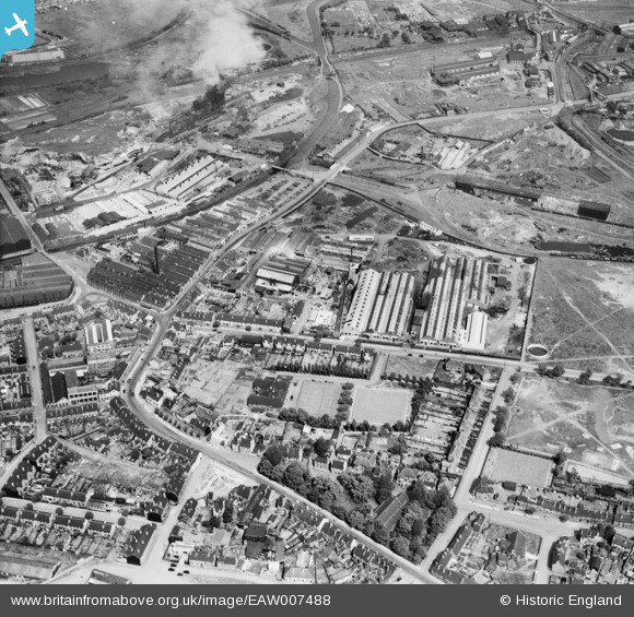
EAW007488 ENGLAND (1947). The Charles Richards and Sons Nut and Bolt Works and the surrounding industrial area, Darlaston Green, 1947
© Copyright OpenStreetMap contributors and licensed by the OpenStreetMap Foundation. 2025. Cartography is licensed as CC BY-SA.
Nearby Images (24)
Details
| Title | [EAW007488] The Charles Richards and Sons Nut and Bolt Works and the surrounding industrial area, Darlaston Green, 1947 |
| Reference | EAW007488 |
| Date | 3-June-1947 |
| Link | |
| Place name | DARLASTON GREEN |
| Parish | |
| District | |
| Country | ENGLAND |
| Easting / Northing | 398003, 297512 |
| Longitude / Latitude | -2.0294712835895, 52.575064395657 |
| National Grid Reference | SO980975 |
Pins
 KevTheBusDriver |
Sunday 28th of June 2015 07:15:58 PM | |
 KevTheBusDriver |
Sunday 28th of June 2015 07:13:42 PM | |
 Bentleyboy |
Sunday 6th of April 2014 06:20:09 PM |


![[EAW007488] The Charles Richards and Sons Nut and Bolt Works and the surrounding industrial area, Darlaston Green, 1947](http://britainfromabove.org.uk/sites/all/libraries/aerofilms-images/public/100x100/EAW/007/EAW007488.jpg)
![[EAW007485] The Charles Richards and Sons Nut and Bolt Works and the surrounding industrial area, Darlaston Green, 1947](http://britainfromabove.org.uk/sites/all/libraries/aerofilms-images/public/100x100/EAW/007/EAW007485.jpg)
![[EAW007486] The Charles Richards and Sons Nut and Bolt Works and the surrounding industrial area, Darlaston Green, 1947](http://britainfromabove.org.uk/sites/all/libraries/aerofilms-images/public/100x100/EAW/007/EAW007486.jpg)
![[EAW007487] The Charles Richards and Sons Nut and Bolt Works and the surrounding industrial area, Darlaston Green, 1947](http://britainfromabove.org.uk/sites/all/libraries/aerofilms-images/public/100x100/EAW/007/EAW007487.jpg)
![[EAW007489] The Charles Richards and Sons Nut and Bolt Works and the surrounding industrial area, Darlaston Green, 1947](http://britainfromabove.org.uk/sites/all/libraries/aerofilms-images/public/100x100/EAW/007/EAW007489.jpg)
![[EPW046091] Richard Street, the Charles Richards and Sons Ltd Imperial Bolt and Nut Works and environs, Darlaston, 1934](http://britainfromabove.org.uk/sites/all/libraries/aerofilms-images/public/100x100/EPW/046/EPW046091.jpg)
![[EPW046099] The Charles Richards and Sons Ltd Midland Works and Imperial Bolt and Nut Works and environs, Darlaston, 1934](http://britainfromabove.org.uk/sites/all/libraries/aerofilms-images/public/100x100/EPW/046/EPW046099.jpg)
![[EAW007484] The Charles Richards and Sons Nut and Bolt Works, Owen Park and the surrounding industrial area, Darlaston Green, 1947](http://britainfromabove.org.uk/sites/all/libraries/aerofilms-images/public/100x100/EAW/007/EAW007484.jpg)
![[EPW046093] The Charles Richards and Sons Ltd Midland Works and Imperial Bolt and Nut Works and environs, Darlaston, 1934](http://britainfromabove.org.uk/sites/all/libraries/aerofilms-images/public/100x100/EPW/046/EPW046093.jpg)
![[EAW007490] The Charles Richards and Sons Nut and Bolt Works and the surrounding industrial area, Darlaston Green, 1947](http://britainfromabove.org.uk/sites/all/libraries/aerofilms-images/public/100x100/EAW/007/EAW007490.jpg)
![[EAW007492] The Charles Richards and Sons Nut and Bolt Works, Darlaston Green, 1947](http://britainfromabove.org.uk/sites/all/libraries/aerofilms-images/public/100x100/EAW/007/EAW007492.jpg)
![[EPW046098] The Charles Richards and Sons Ltd Midland Works and Imperial Bolt and Nut Works, Darlaston, 1934](http://britainfromabove.org.uk/sites/all/libraries/aerofilms-images/public/100x100/EPW/046/EPW046098.jpg)
![[EPW046092] Richard Street, the Charles Richards and Sons Ltd Imperial Bolt and Nut Works and environs, Darlaston, 1934](http://britainfromabove.org.uk/sites/all/libraries/aerofilms-images/public/100x100/EPW/046/EPW046092.jpg)
![[EPW046096] The Charles Richards and Sons Ltd Midland Works and Imperial Bolt and Nut Works, Darlaston, 1934](http://britainfromabove.org.uk/sites/all/libraries/aerofilms-images/public/100x100/EPW/046/EPW046096.jpg)
![[EPW046097] The Charles Richards and Sons Ltd Midland Works and Imperial Bolt and Nut Works, Darlaston, 1934](http://britainfromabove.org.uk/sites/all/libraries/aerofilms-images/public/100x100/EPW/046/EPW046097.jpg)
![[EPW046095] The Charles Richards and Sons Ltd Midland Works and Imperial Bolt and Nut Works, Darlaston, 1934](http://britainfromabove.org.uk/sites/all/libraries/aerofilms-images/public/100x100/EPW/046/EPW046095.jpg)
![[EAW007494] The Charles Richards and Sons Nut and Bolt Works, Darlaston Green, 1947](http://britainfromabove.org.uk/sites/all/libraries/aerofilms-images/public/100x100/EAW/007/EAW007494.jpg)
![[EAW007493] The Charles Richards and Sons Nut and Bolt Works, Darlaston Green, 1947](http://britainfromabove.org.uk/sites/all/libraries/aerofilms-images/public/100x100/EAW/007/EAW007493.jpg)
![[EAW007491] The Charles Richards and Sons Nut and Bolt Works, Darlaston Green, 1947](http://britainfromabove.org.uk/sites/all/libraries/aerofilms-images/public/100x100/EAW/007/EAW007491.jpg)
![[EPW046094] The Charles Richards and Sons Ltd Imperial Bolt and Nut Works and environs, Darlaston, 1934](http://britainfromabove.org.uk/sites/all/libraries/aerofilms-images/public/100x100/EPW/046/EPW046094.jpg)
![[EPW046087] The Charles Richards and Sons Ltd Imperial Bolt and Nut Works, Darlaston, 1934](http://britainfromabove.org.uk/sites/all/libraries/aerofilms-images/public/100x100/EPW/046/EPW046087.jpg)
![[EPW046088] The Charles Richards and Sons Ltd Imperial Bolt and Nut Works, Darlaston, 1934](http://britainfromabove.org.uk/sites/all/libraries/aerofilms-images/public/100x100/EPW/046/EPW046088.jpg)
![[EPW046089] The Charles Richards and Sons Ltd Imperial Bolt and Nut Works, Darlaston, 1934](http://britainfromabove.org.uk/sites/all/libraries/aerofilms-images/public/100x100/EPW/046/EPW046089.jpg)
![[EPW046090] The Charles Richards and Sons Ltd Imperial Bolt and Nut Works, Darlaston, 1934](http://britainfromabove.org.uk/sites/all/libraries/aerofilms-images/public/100x100/EPW/046/EPW046090.jpg)