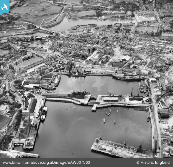
EAW007563 ENGLAND (1947). Millbay Docks and environs, Stonehouse, 1947
© Copyright OpenStreetMap contributors and licensed by the OpenStreetMap Foundation. 2025. Cartography is licensed as CC BY-SA.
Nearby Images (15)
Details
| Title | [EAW007563] Millbay Docks and environs, Stonehouse, 1947 |
| Reference | EAW007563 |
| Date | 25-June-1947 |
| Link | |
| Place name | STONEHOUSE |
| Parish | |
| District | |
| Country | ENGLAND |
| Easting / Northing | 246684, 54070 |
| Longitude / Latitude | -4.1559875504252, 50.365921228223 |
| National Grid Reference | SX467541 |


![[EAW007563] Millbay Docks and environs, Stonehouse, 1947](http://britainfromabove.org.uk/sites/all/libraries/aerofilms-images/public/100x100/EAW/007/EAW007563.jpg)
![[EAW006010] The Great Western Docks (Millbay) and Stonehouse, Plymouth, 1947. This image was marked by Aerofilms Ltd for photo editing.](http://britainfromabove.org.uk/sites/all/libraries/aerofilms-images/public/100x100/EAW/006/EAW006010.jpg)
![[EAW006009] The Great Western Docks (Millbay) and Stonehouse, Plymouth, 1947. This image was marked by Aerofilms Ltd for photo editing.](http://britainfromabove.org.uk/sites/all/libraries/aerofilms-images/public/100x100/EAW/006/EAW006009.jpg)
![[EAW007567] The Inner Basin Graving Dock and environs, Stonehouse, 1947. This image has been produced from a print.](http://britainfromabove.org.uk/sites/all/libraries/aerofilms-images/public/100x100/EAW/007/EAW007567.jpg)
![[EAW006011] The Great Western Docks (Millbay) and Stonehouse, Plymouth, 1947. This image was marked by Aerofilms Ltd for photo editing.](http://britainfromabove.org.uk/sites/all/libraries/aerofilms-images/public/100x100/EAW/006/EAW006011.jpg)
![[EAW007565] Millbay Docks, Stonehouse, 1947. This image has been produced from a print.](http://britainfromabove.org.uk/sites/all/libraries/aerofilms-images/public/100x100/EAW/007/EAW007565.jpg)
![[EAW010748] Stonehouse, The Sound and environs, Plymouth, from the north-west, 1947](http://britainfromabove.org.uk/sites/all/libraries/aerofilms-images/public/100x100/EAW/010/EAW010748.jpg)
![[EPW054889] The Great Western Docks, Plymouth, 1937](http://britainfromabove.org.uk/sites/all/libraries/aerofilms-images/public/100x100/EPW/054/EPW054889.jpg)
![[EAW006012] The Great Western Docks (Millbay), the Eastern King battery and Stonehouse, Plymouth, 1947](http://britainfromabove.org.uk/sites/all/libraries/aerofilms-images/public/100x100/EAW/006/EAW006012.jpg)
![[EAW007571] Millbay Docks and environs, Stonehouse, 1947](http://britainfromabove.org.uk/sites/all/libraries/aerofilms-images/public/100x100/EAW/007/EAW007571.jpg)
![[EAW051361] Great Western Docks (Millbay Docks), Stonehouse, 1953](http://britainfromabove.org.uk/sites/all/libraries/aerofilms-images/public/100x100/EAW/051/EAW051361.jpg)
![[EAW006016] The Great Western Docks (Millbay) and Stonehouse, Plymouth, 1947. This image was marked by Aerofilms Ltd for photo editing.](http://britainfromabove.org.uk/sites/all/libraries/aerofilms-images/public/100x100/EAW/006/EAW006016.jpg)
![[EAW006013] The Great Western Docks (Millbay), the Eastern King battery and Stonehouse, Plymouth, 1947](http://britainfromabove.org.uk/sites/all/libraries/aerofilms-images/public/100x100/EAW/006/EAW006013.jpg)
![[EAW007564] Millbay Docks and environs, Stonehouse, 1947](http://britainfromabove.org.uk/sites/all/libraries/aerofilms-images/public/100x100/EAW/007/EAW007564.jpg)
![[EAW007568] Millbay Docks and environs, Stonehouse, 1947](http://britainfromabove.org.uk/sites/all/libraries/aerofilms-images/public/100x100/EAW/007/EAW007568.jpg)

