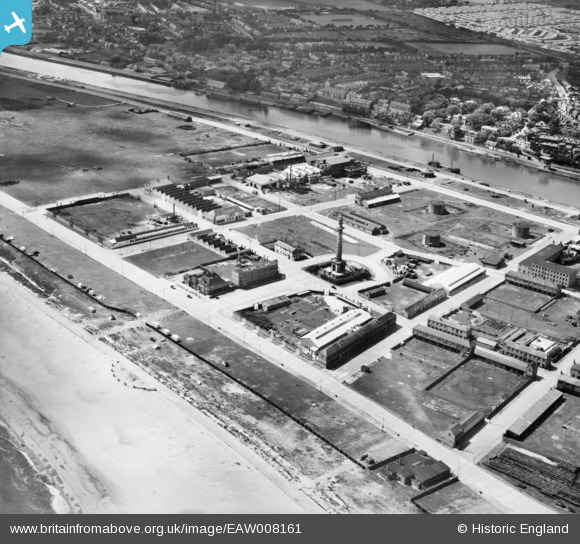
EAW008161 ENGLAND (1947). Nelson's Monument and environs, Great Yarmouth, 1947
© Copyright OpenStreetMap contributors and licensed by the OpenStreetMap Foundation. 2025. Cartography is licensed as CC BY-SA.
Nearby Images (33)
Details
| Title | [EAW008161] Nelson's Monument and environs, Great Yarmouth, 1947 |
| Reference | EAW008161 |
| Date | 12-July-1947 |
| Link | |
| Place name | GREAT YARMOUTH |
| Parish | |
| District | |
| Country | ENGLAND |
| Easting / Northing | 653007, 305467 |
| Longitude / Latitude | 1.7355832023981, 52.587653932842 |
| National Grid Reference | TG530055 |
Pins
 redmist |
Tuesday 18th of January 2022 08:00:39 PM | |
 redmist |
Tuesday 18th of January 2022 08:00:02 PM | |
 redmist |
Tuesday 18th of January 2022 01:50:48 PM | |
 Matt Aldred edob.mattaldred.com |
Sunday 27th of December 2020 03:49:38 PM | |
 Matt Aldred edob.mattaldred.com |
Sunday 27th of December 2020 03:45:21 PM | |
 Matt Aldred edob.mattaldred.com |
Sunday 27th of December 2020 03:41:02 PM | |
 Sparky |
Monday 2nd of October 2017 08:31:57 AM | |
 Al |
Monday 13th of January 2014 12:05:09 AM |


![[EAW008161] Nelson's Monument and environs, Great Yarmouth, 1947](http://britainfromabove.org.uk/sites/all/libraries/aerofilms-images/public/100x100/EAW/008/EAW008161.jpg)
![[EAW008160] Nelson's Monument and environs, Great Yarmouth, 1947](http://britainfromabove.org.uk/sites/all/libraries/aerofilms-images/public/100x100/EAW/008/EAW008160.jpg)
![[EAW008170] Nelson's Monument, Fenner Road and environs, Great Yarmouth, 1947](http://britainfromabove.org.uk/sites/all/libraries/aerofilms-images/public/100x100/EAW/008/EAW008170.jpg)
![[EAW008159] Nelson's Monument and environs, Great Yarmouth, 1947](http://britainfromabove.org.uk/sites/all/libraries/aerofilms-images/public/100x100/EAW/008/EAW008159.jpg)
![[EPW021183] South Beach, Nelson's Monument and the River Yare, Great Yarmouth, 1928](http://britainfromabove.org.uk/sites/all/libraries/aerofilms-images/public/100x100/EPW/021/EPW021183.jpg)
![[EAW008171] Marine Parade South, Nelson's Monument and environs, Great Yarmouth, 1947](http://britainfromabove.org.uk/sites/all/libraries/aerofilms-images/public/100x100/EAW/008/EAW008171.jpg)
![[EAW008162] Nelson's Monument, Marine Parade South and environs, Great Yarmouth, 1947](http://britainfromabove.org.uk/sites/all/libraries/aerofilms-images/public/100x100/EAW/008/EAW008162.jpg)
![[EAW008168] Nelson's Monument and environs, Great Yarmouth, 1947](http://britainfromabove.org.uk/sites/all/libraries/aerofilms-images/public/100x100/EAW/008/EAW008168.jpg)
![[EAW008163] Fenner Road, Marine Parade South and environs, Great Yarmouth, 1947](http://britainfromabove.org.uk/sites/all/libraries/aerofilms-images/public/100x100/EAW/008/EAW008163.jpg)
![[EAW008167] Nelson's Monument, Fenner Road and Marine Parade South, Great Yarmouth, 1947](http://britainfromabove.org.uk/sites/all/libraries/aerofilms-images/public/100x100/EAW/008/EAW008167.jpg)
![[EAW008165] Beevor Road and environs looking towards the River Yare, Great Yarmouth, from the south-east, 1947. This image was marked by Aerofilms Ltd for photo editing.](http://britainfromabove.org.uk/sites/all/libraries/aerofilms-images/public/100x100/EAW/008/EAW008165.jpg)
![[EAW008158] Nelson's Monument, Beevor Road and environs, Great Yarmouth, 1947](http://britainfromabove.org.uk/sites/all/libraries/aerofilms-images/public/100x100/EAW/008/EAW008158.jpg)
![[EAW008164] Fenner Road, Nelson's Monument and the town, Great Yarmouth, from the south, 1947. This image was marked by Aerofilms Ltd for photo editing.](http://britainfromabove.org.uk/sites/all/libraries/aerofilms-images/public/100x100/EAW/008/EAW008164.jpg)
![[EAW008169] Factories between Bloomfield Road and Beevor Road, Great Yarmouth, 1947](http://britainfromabove.org.uk/sites/all/libraries/aerofilms-images/public/100x100/EAW/008/EAW008169.jpg)
![[EAW027510] The Birds Eye Foods Ltd Canning Factory on South Denes Road, Great Yarmouth, 1949. This image was marked by Aerofilms Ltd for photo editing.](http://britainfromabove.org.uk/sites/all/libraries/aerofilms-images/public/100x100/EAW/027/EAW027510.jpg)
![[EAW027503] The Birds Eye Foods Ltd Canning Factory on South Denes Road and environs, Great Yarmouth, 1949. This image was marked by Aerofilms Ltd for photo editing.](http://britainfromabove.org.uk/sites/all/libraries/aerofilms-images/public/100x100/EAW/027/EAW027503.jpg)
![[EAW047610] The Birds Eye Foods Ltd factory on South Denes Road, Great Yarmouth, 1952. This image was marked by Aerofilms Ltd for photo editing.](http://britainfromabove.org.uk/sites/all/libraries/aerofilms-images/public/100x100/EAW/047/EAW047610.jpg)
![[EAW047612] The Birds Eye Foods Ltd factory on South Denes Road, Great Yarmouth, 1952. This image was marked by Aerofilms Ltd for photo editing.](http://britainfromabove.org.uk/sites/all/libraries/aerofilms-images/public/100x100/EAW/047/EAW047612.jpg)
![[EAW027504] The Birds Eye Foods Ltd Canning Factory on South Denes Road, Great Yarmouth, 1949. This image was marked by Aerofilms Ltd for photo editing.](http://britainfromabove.org.uk/sites/all/libraries/aerofilms-images/public/100x100/EAW/027/EAW027504.jpg)
![[EAW047608] The Birds Eye Foods Ltd factory on South Denes Road, Great Yarmouth, 1952. This image was marked by Aerofilms Ltd for photo editing.](http://britainfromabove.org.uk/sites/all/libraries/aerofilms-images/public/100x100/EAW/047/EAW047608.jpg)
![[EAW027502] The Birds Eye Foods Ltd Canning Factory on South Denes Road, Great Yarmouth, 1949. This image was marked by Aerofilms Ltd for photo editing.](http://britainfromabove.org.uk/sites/all/libraries/aerofilms-images/public/100x100/EAW/027/EAW027502.jpg)
![[EAW027507] The Birds Eye Foods Ltd Canning Factory on South Denes Road and the River Yare, Great Yarmouth, 1949. This image was marked by Aerofilms Ltd for photo editing.](http://britainfromabove.org.uk/sites/all/libraries/aerofilms-images/public/100x100/EAW/027/EAW027507.jpg)
![[EAW027505] The Birds Eye Foods Ltd Canning Factory on South Denes Road and environs, Great Yarmouth, 1949. This image was marked by Aerofilms Ltd for photo editing.](http://britainfromabove.org.uk/sites/all/libraries/aerofilms-images/public/100x100/EAW/027/EAW027505.jpg)
![[EAW027508] The Birds Eye Foods Ltd Canning Factory on South Denes Road, Great Yarmouth, 1949. This image was marked by Aerofilms Ltd for photo editing.](http://britainfromabove.org.uk/sites/all/libraries/aerofilms-images/public/100x100/EAW/027/EAW027508.jpg)
![[EAW027506] The Birds Eye Foods Ltd Canning Factory on South Denes Road and the River Yare, Great Yarmouth, 1949. This image was marked by Aerofilms Ltd for photo editing.](http://britainfromabove.org.uk/sites/all/libraries/aerofilms-images/public/100x100/EAW/027/EAW027506.jpg)
![[EAW047611] The Birds Eye Foods Ltd factory on South Denes Road, Great Yarmouth, 1952. This image was marked by Aerofilms Ltd for photo editing.](http://britainfromabove.org.uk/sites/all/libraries/aerofilms-images/public/100x100/EAW/047/EAW047611.jpg)
![[EAW047614] The Birds Eye Foods Ltd factory on South Denes Road, Great Yarmouth, 1952. This image was marked by Aerofilms Ltd for photo editing.](http://britainfromabove.org.uk/sites/all/libraries/aerofilms-images/public/100x100/EAW/047/EAW047614.jpg)
![[EAW047616] The Birds Eye Foods Ltd factory on South Denes Road, Great Yarmouth, 1952. This image was marked by Aerofilms Ltd for photo editing.](http://britainfromabove.org.uk/sites/all/libraries/aerofilms-images/public/100x100/EAW/047/EAW047616.jpg)
![[EAW047615] The Birds Eye Foods Ltd factory on South Denes Road, Great Yarmouth, 1952. This image was marked by Aerofilms Ltd for photo editing.](http://britainfromabove.org.uk/sites/all/libraries/aerofilms-images/public/100x100/EAW/047/EAW047615.jpg)
![[EAW047613] The Birds Eye Foods Ltd factory on South Denes Road, Great Yarmouth, 1952. This image was marked by Aerofilms Ltd for photo editing.](http://britainfromabove.org.uk/sites/all/libraries/aerofilms-images/public/100x100/EAW/047/EAW047613.jpg)
![[EAW047609] The Birds Eye Foods Ltd factory on South Denes Road, Great Yarmouth, 1952. This image was marked by Aerofilms Ltd for photo editing.](http://britainfromabove.org.uk/sites/all/libraries/aerofilms-images/public/100x100/EAW/047/EAW047609.jpg)
![[EAW027509] The Birds Eye Foods Ltd Canning Factory on South Denes Road, Great Yarmouth, 1949](http://britainfromabove.org.uk/sites/all/libraries/aerofilms-images/public/100x100/EAW/027/EAW027509.jpg)
![[EAW027501] The Birds Eye Foods Ltd Canning Factory on South Denes Road, Great Yarmouth, from the south-west, 1949](http://britainfromabove.org.uk/sites/all/libraries/aerofilms-images/public/100x100/EAW/027/EAW027501.jpg)