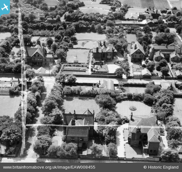
EAW008455 ENGLAND (1947). Ashleigh house (105 Newport Street) and the surrounding residential area, Oldham, 1947. This image was marked by Aerofilms Ltd for photo editing.
© Copyright OpenStreetMap contributors and licensed by the OpenStreetMap Foundation. 2025. Cartography is licensed as CC BY-SA.
Nearby Images (21)
Details
| Title | [EAW008455] Ashleigh house (105 Newport Street) and the surrounding residential area, Oldham, 1947. This image was marked by Aerofilms Ltd for photo editing. |
| Reference | EAW008455 |
| Date | 27-July-1947 |
| Link | |
| Place name | OLDHAM |
| Parish | |
| District | |
| Country | ENGLAND |
| Easting / Northing | 391700, 404084 |
| Longitude / Latitude | -2.1252368354396, 53.533099266473 |
| National Grid Reference | SD917041 |
Pins
 eddief |
Thursday 28th of November 2013 11:16:52 AM | |
 eddief |
Thursday 28th of November 2013 11:16:09 AM | |
 eddief |
Thursday 28th of November 2013 11:03:04 AM | |
 eddief |
Thursday 28th of November 2013 10:58:42 AM | |
 eddief |
Thursday 28th of November 2013 10:57:35 AM |


![[EAW008455] Ashleigh house (105 Newport Street) and the surrounding residential area, Oldham, 1947. This image was marked by Aerofilms Ltd for photo editing.](http://britainfromabove.org.uk/sites/all/libraries/aerofilms-images/public/100x100/EAW/008/EAW008455.jpg)
![[EAW008456] Ashleigh house (105 Newport Street) looking towards the Werneth Cotton Mill, Oldham, 1947](http://britainfromabove.org.uk/sites/all/libraries/aerofilms-images/public/100x100/EAW/008/EAW008456.jpg)
![[EAW008457] Ashleigh house (105 Newport Street) and the surrounding residential area, Oldham, 1947](http://britainfromabove.org.uk/sites/all/libraries/aerofilms-images/public/100x100/EAW/008/EAW008457.jpg)
![[EAW008451] Ashleigh house (105 Newport Street) and the surrounding residential area, Oldham, 1947](http://britainfromabove.org.uk/sites/all/libraries/aerofilms-images/public/100x100/EAW/008/EAW008451.jpg)
![[EAW008453] Ashleigh house (105 Newport Street) and the surrounding residential area, Oldham, 1947. This image was marked by Aerofilms Ltd for photo editing.](http://britainfromabove.org.uk/sites/all/libraries/aerofilms-images/public/100x100/EAW/008/EAW008453.jpg)
![[EAW008454] Ashleigh house (105 Newport Street) and the surrounding residential area, Oldham, 1947. This image was marked by Aerofilms Ltd for photo editing.](http://britainfromabove.org.uk/sites/all/libraries/aerofilms-images/public/100x100/EAW/008/EAW008454.jpg)
![[EAW004258] Private houses along Osborne Road and Frederick Street looking towards Werneth Park, Oldham, from the north-east, 1947. This image was marked by Aerofilms Ltd for photo editing.](http://britainfromabove.org.uk/sites/all/libraries/aerofilms-images/public/100x100/EAW/004/EAW004258.jpg)
![[EAW008452] Ashleigh house (105 Newport Street) and the surrounding residential area, Oldham, 1947](http://britainfromabove.org.uk/sites/all/libraries/aerofilms-images/public/100x100/EAW/008/EAW008452.jpg)
![[EAW004255] Ashleigh and Toravon on Frederick Street and environs, Oldham, from the south-west, 1947. This image was marked by Aerofilms Ltd for photo editing.](http://britainfromabove.org.uk/sites/all/libraries/aerofilms-images/public/100x100/EAW/004/EAW004255.jpg)
![[EAW004259] Private houses along Frederick Street and environs, Oldham, from the east, 1947. This image was marked by Aerofilms Ltd for photo editing.](http://britainfromabove.org.uk/sites/all/libraries/aerofilms-images/public/100x100/EAW/004/EAW004259.jpg)
![[EAW004257] Ashleigh, Toravon,Westholme and Thornycroft on Frederick Street and environs, Oldham, from the south-west, 1947](http://britainfromabove.org.uk/sites/all/libraries/aerofilms-images/public/100x100/EAW/004/EAW004257.jpg)
![[EAW004260] Private houses along Osborne Road and Frederick Street looking towards Werneth Park, Oldham, from the north-east, 1947. This image was marked by Aerofilms Ltd for photo editing.](http://britainfromabove.org.uk/sites/all/libraries/aerofilms-images/public/100x100/EAW/004/EAW004260.jpg)
![[EAW004256] Ashleigh, Toravon,Westholme and Thornycroft on Frederick Street and environs, Oldham, from the south-west, 1947. This image was marked by Aerofilms Ltd for photo editing.](http://britainfromabove.org.uk/sites/all/libraries/aerofilms-images/public/100x100/EAW/004/EAW004256.jpg)
![[EAW004287] Werneth Cotton Mill and environs, Oldham, 1947. This image was marked by Aerofilms Ltd for photo editing.](http://britainfromabove.org.uk/sites/all/libraries/aerofilms-images/public/100x100/EAW/004/EAW004287.jpg)
![[EAW004284] Werneth Park, Werneth Cotton Mill and the town, Oldham, from the south-east, 1947](http://britainfromabove.org.uk/sites/all/libraries/aerofilms-images/public/100x100/EAW/004/EAW004284.jpg)
![[EAW004289] Werneth Cotton Mill and environs, Oldham, from the south-west, 1947. This image was marked by Aerofilms Ltd for photo editing.](http://britainfromabove.org.uk/sites/all/libraries/aerofilms-images/public/100x100/EAW/004/EAW004289.jpg)
![[EAW004286] Werneth Cotton Mill and environs, Oldham, from the south-west, 1947. This image was marked by Aerofilms Ltd for photo editing.](http://britainfromabove.org.uk/sites/all/libraries/aerofilms-images/public/100x100/EAW/004/EAW004286.jpg)
![[EPW050222] Werneth Cotton Mill, Featherstall Road South and environs, Oldham, from the south, 1936](http://britainfromabove.org.uk/sites/all/libraries/aerofilms-images/public/100x100/EPW/050/EPW050222.jpg)
![[EPW050220] Werneth Cotton Mill and environs, Oldham, 1936](http://britainfromabove.org.uk/sites/all/libraries/aerofilms-images/public/100x100/EPW/050/EPW050220.jpg)
![[EPW050221] Werneth Cotton Mill, Oldham, 1936](http://britainfromabove.org.uk/sites/all/libraries/aerofilms-images/public/100x100/EPW/050/EPW050221.jpg)
![[EPW050223] Werneth Cotton Mill and environs, Oldham, from the south-west, 1936](http://britainfromabove.org.uk/sites/all/libraries/aerofilms-images/public/100x100/EPW/050/EPW050223.jpg)