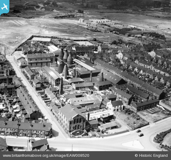
EAW008520 ENGLAND (1947). The Elder Earthenware Works, Cobridge, 1947
© Copyright OpenStreetMap contributors and licensed by the OpenStreetMap Foundation. 2025. Cartography is licensed as CC BY-SA.
Nearby Images (18)
Details
| Title | [EAW008520] The Elder Earthenware Works, Cobridge, 1947 |
| Reference | EAW008520 |
| Date | 22-July-1947 |
| Link | |
| Place name | COBRIDGE |
| Parish | |
| District | |
| Country | ENGLAND |
| Easting / Northing | 387526, 348827 |
| Longitude / Latitude | -2.1860468516957, 53.036270724548 |
| National Grid Reference | SJ875488 |
Pins
 GB |
Sunday 17th of September 2023 01:44:21 PM | |
 GB |
Sunday 17th of September 2023 01:43:39 PM | |
 GB |
Sunday 17th of September 2023 01:41:05 PM | |
 GB |
Sunday 17th of September 2023 01:40:34 PM | |
 Wonomma |
Sunday 1st of March 2015 04:57:39 PM | |
 bescotbeast |
Wednesday 24th of September 2014 09:09:40 PM |


![[EAW008520] The Elder Earthenware Works, Cobridge, 1947](http://britainfromabove.org.uk/sites/all/libraries/aerofilms-images/public/100x100/EAW/008/EAW008520.jpg)
![[EAW008519] The Elder Earthenware Works, Cobridge, 1947](http://britainfromabove.org.uk/sites/all/libraries/aerofilms-images/public/100x100/EAW/008/EAW008519.jpg)
![[EAW008516] The Elder Earthenware Works, Cobridge, 1947](http://britainfromabove.org.uk/sites/all/libraries/aerofilms-images/public/100x100/EAW/008/EAW008516.jpg)
![[EAW008517] The Elder Earthenware Works, Cobridge, 1947](http://britainfromabove.org.uk/sites/all/libraries/aerofilms-images/public/100x100/EAW/008/EAW008517.jpg)
![[EAW008525] The Elder Earthenware Works, Cobridge, 1947](http://britainfromabove.org.uk/sites/all/libraries/aerofilms-images/public/100x100/EAW/008/EAW008525.jpg)
![[EAW008518] The Elder Earthenware Works, Cobridge, 1947](http://britainfromabove.org.uk/sites/all/libraries/aerofilms-images/public/100x100/EAW/008/EAW008518.jpg)
![[EPW053365] The Elder Works (Earthenware) and St Peter's Roman Catholic Church, Cobridge, 1937](http://britainfromabove.org.uk/sites/all/libraries/aerofilms-images/public/100x100/EPW/053/EPW053365.jpg)
![[EAW008525A] The Elder Earthenware Works and environs, Cobridge, 1947](http://britainfromabove.org.uk/sites/all/libraries/aerofilms-images/public/100x100/EAW/008/EAW008525A.jpg)
![[EAW008527] The Elder Earthenware Works, Cobridge, 1947](http://britainfromabove.org.uk/sites/all/libraries/aerofilms-images/public/100x100/EAW/008/EAW008527.jpg)
![[EPW053362] The Elder Works (Earthenware) and St Peter's Roman Catholic Church, Cobridge, 1937. This image has been affected by flare.](http://britainfromabove.org.uk/sites/all/libraries/aerofilms-images/public/100x100/EPW/053/EPW053362.jpg)
![[EAW008523] The Elder Earthenware Works, Cobridge, 1947](http://britainfromabove.org.uk/sites/all/libraries/aerofilms-images/public/100x100/EAW/008/EAW008523.jpg)
![[EPW053361] The Elder Works (Earthenware) and St Peter's Roman Catholic Church, Cobridge, 1937](http://britainfromabove.org.uk/sites/all/libraries/aerofilms-images/public/100x100/EPW/053/EPW053361.jpg)
![[EAW008521] The Elder Earthenware Works, Cobridge, 1947](http://britainfromabove.org.uk/sites/all/libraries/aerofilms-images/public/100x100/EAW/008/EAW008521.jpg)
![[EPW053364] The Elder Works (Earthenware) and St Peter's Roman Catholic Church, Cobridge, 1937](http://britainfromabove.org.uk/sites/all/libraries/aerofilms-images/public/100x100/EPW/053/EPW053364.jpg)
![[EPW053360] The Elder Works (Earthenware) and St Peter's Roman Catholic Church, Cobridge, 1937](http://britainfromabove.org.uk/sites/all/libraries/aerofilms-images/public/100x100/EPW/053/EPW053360.jpg)
![[EPW053363] The Elder Works (Earthenware), St Peter's Roman Catholic Church and Christ Church, Cobridge, 1937](http://britainfromabove.org.uk/sites/all/libraries/aerofilms-images/public/100x100/EPW/053/EPW053363.jpg)
![[EAW008522] The Elder Earthenware Works and the Greyhound Racing Track, Cobridge, 1947](http://britainfromabove.org.uk/sites/all/libraries/aerofilms-images/public/100x100/EAW/008/EAW008522.jpg)
![[EAW008524] The Elder Earthenware Works, Cobridge, 1947](http://britainfromabove.org.uk/sites/all/libraries/aerofilms-images/public/100x100/EAW/008/EAW008524.jpg)