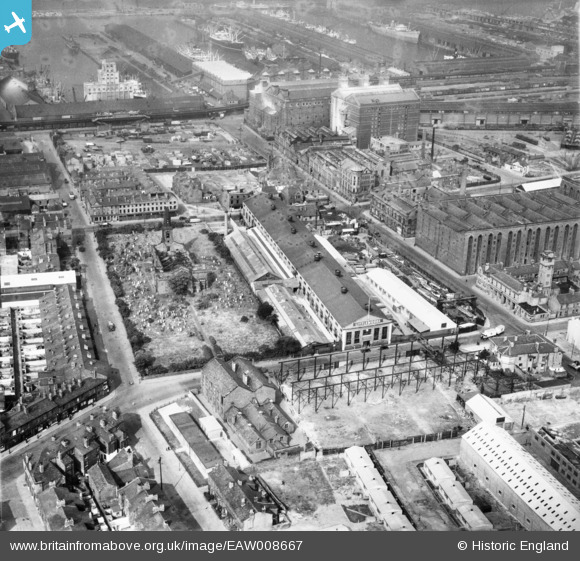
EAW008667 ENGLAND (1947). The Littlewoods Building on Irlam Road, the ruins of St Mary's Church and environs, Bootle, 1947
© Copyright OpenStreetMap contributors and licensed by the OpenStreetMap Foundation. 2025. Cartography is licensed as CC BY-SA.
Nearby Images (12)
Details
| Title | [EAW008667] The Littlewoods Building on Irlam Road, the ruins of St Mary's Church and environs, Bootle, 1947 |
| Reference | EAW008667 |
| Date | 1-August-1947 |
| Link | |
| Place name | BOOTLE |
| Parish | |
| District | |
| Country | ENGLAND |
| Easting / Northing | 333658, 395244 |
| Longitude / Latitude | -2.9990678569769, 53.449520743591 |
| National Grid Reference | SJ337952 |


![[EAW008667] The Littlewoods Building on Irlam Road, the ruins of St Mary's Church and environs, Bootle, 1947](http://britainfromabove.org.uk/sites/all/libraries/aerofilms-images/public/100x100/EAW/008/EAW008667.jpg)
![[EAW008669] The Littlewoods Building on Irlam Road, the ruins of St Mary's Church and environs, Bootle, 1947](http://britainfromabove.org.uk/sites/all/libraries/aerofilms-images/public/100x100/EAW/008/EAW008669.jpg)
![[EAW008687] The Littlewoods Building on Irlam Road and environs, Bootle, 1947. This image was marked by Aerofilms Ltd for photo editing.](http://britainfromabove.org.uk/sites/all/libraries/aerofilms-images/public/100x100/EAW/008/EAW008687.jpg)
![[EAW008670] The Littlewoods Building on Irlam Road, the ruins of St Mary's Church and environs, Bootle, 1947](http://britainfromabove.org.uk/sites/all/libraries/aerofilms-images/public/100x100/EAW/008/EAW008670.jpg)
![[EAW008668] Strand Road, the Littlewoods Building on Irlam Road and environs, Bootle, 1947](http://britainfromabove.org.uk/sites/all/libraries/aerofilms-images/public/100x100/EAW/008/EAW008668.jpg)
![[EAW008671] The Littlewoods Building on Irlam Road, the ruins of St Mary's Church and environs, Bootle, 1947](http://britainfromabove.org.uk/sites/all/libraries/aerofilms-images/public/100x100/EAW/008/EAW008671.jpg)
![[EAW008681] Harland and Wolff Buildings on Strand Road, Alexandra Warehouse (No. 2) and environs, Bootle, 1947. This image was marked by Aerofilms Ltd for photo editing.](http://britainfromabove.org.uk/sites/all/libraries/aerofilms-images/public/100x100/EAW/008/EAW008681.jpg)
![[EAW008672] Harland and Wolff Buildings on Strand Road, Alexandra Warehouse (No. 1) and environs, Bootle, 1947](http://britainfromabove.org.uk/sites/all/libraries/aerofilms-images/public/100x100/EAW/008/EAW008672.jpg)
![[EAW008684] Harland and Wolff Buildings on Strand Road, Alexandra Warehouse (No. 2) and environs, Bootle, 1947. This image was marked by Aerofilms Ltd for photo editing.](http://britainfromabove.org.uk/sites/all/libraries/aerofilms-images/public/100x100/EAW/008/EAW008684.jpg)
![[EAW008688] Warehouses and industrial sites around Rimrose Road, Bootle, 1947. This image was marked by Aerofilms Ltd for photo editing.](http://britainfromabove.org.uk/sites/all/libraries/aerofilms-images/public/100x100/EAW/008/EAW008688.jpg)
![[EAW008682] Harland and Wolff Buildings on Strand Road, Alexandra Warehouses (1 & 2) and environs, Bootle, 1947](http://britainfromabove.org.uk/sites/all/libraries/aerofilms-images/public/100x100/EAW/008/EAW008682.jpg)
![[EAW008683] Harland and Wolff Buildings on Strand Road, Alexandra Warehouse (No. 2) and environs, Bootle, 1947. This image was marked by Aerofilms Ltd for photo editing.](http://britainfromabove.org.uk/sites/all/libraries/aerofilms-images/public/100x100/EAW/008/EAW008683.jpg)
