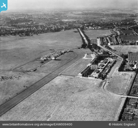
EAW009400 ENGLAND (1947). York Racecourse, York, from the south-east, 1947. This image has been produced from a print.
© Copyright OpenStreetMap contributors and licensed by the OpenStreetMap Foundation. 2025. Cartography is licensed as CC BY-SA.
Nearby Images (8)
Details
| Title | [EAW009400] York Racecourse, York, from the south-east, 1947. This image has been produced from a print. |
| Reference | EAW009400 |
| Date | 17-August-1947 |
| Link | |
| Place name | YORK |
| Parish | |
| District | |
| Country | ENGLAND |
| Easting / Northing | 459739, 449449 |
| Longitude / Latitude | -1.089906383119, 53.937507942592 |
| National Grid Reference | SE597494 |
Pins
Be the first to add a comment to this image!


![[EAW009400] York Racecourse, York, from the south-east, 1947. This image has been produced from a print.](http://britainfromabove.org.uk/sites/all/libraries/aerofilms-images/public/100x100/EAW/009/EAW009400.jpg)
![[EPW039051] The York Military Tattoo campsite and York Racecourse, Knavesmire, 1932](http://britainfromabove.org.uk/sites/all/libraries/aerofilms-images/public/100x100/EPW/039/EPW039051.jpg)
![[EPW016074] Tents and marquees at York Racecourse, York, 1926](http://britainfromabove.org.uk/sites/all/libraries/aerofilms-images/public/100x100/EPW/016/EPW016074.jpg)
![[EPW039052] The York Military Tattoo campsite and York Racecourse, Knavesmire, 1932](http://britainfromabove.org.uk/sites/all/libraries/aerofilms-images/public/100x100/EPW/039/EPW039052.jpg)
![[EAW009407] Grand Stands at York Racecourse, York, from the south-west, 1947. This image has been produced from a print.](http://britainfromabove.org.uk/sites/all/libraries/aerofilms-images/public/100x100/EAW/009/EAW009407.jpg)
![[EAW009404] York Racecourse, York, 1947. This image has been produced from a print.](http://britainfromabove.org.uk/sites/all/libraries/aerofilms-images/public/100x100/EAW/009/EAW009404.jpg)
![[EAW016676] The Royal Agricultural Showground at York Racecourse (The Knavesmire), York, from the south-east, 1948](http://britainfromabove.org.uk/sites/all/libraries/aerofilms-images/public/100x100/EAW/016/EAW016676.jpg)
![[EPW039034] Terry's Chocolate Factory and stands at York Racecourse, York, 1932](http://britainfromabove.org.uk/sites/all/libraries/aerofilms-images/public/100x100/EPW/039/EPW039034.jpg)