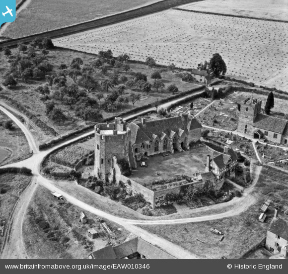
EAW010346 ENGLAND (1947). Stokesay Castle and the Church of St John the Baptist, Stokesay, 1947
© Copyright OpenStreetMap contributors and licensed by the OpenStreetMap Foundation. 2025. Cartography is licensed as CC BY-SA.
Nearby Images (9)
Details
| Title | [EAW010346] Stokesay Castle and the Church of St John the Baptist, Stokesay, 1947 |
| Reference | EAW010346 |
| Date | 28-August-1947 |
| Link | |
| Place name | STOKESAY |
| Parish | CRAVEN ARMS |
| District | |
| Country | ENGLAND |
| Easting / Northing | 343565, 281689 |
| Longitude / Latitude | -2.8301235875171, 52.429890376972 |
| National Grid Reference | SO436817 |
Pins
 John Wass |
Friday 24th of April 2015 09:20:01 PM |


![[EAW010346] Stokesay Castle and the Church of St John the Baptist, Stokesay, 1947](http://britainfromabove.org.uk/sites/all/libraries/aerofilms-images/public/100x100/EAW/010/EAW010346.jpg)
![[EAW010343] Stokesay Castle and the Church of St John the Baptist, Stokesay, 1947](http://britainfromabove.org.uk/sites/all/libraries/aerofilms-images/public/100x100/EAW/010/EAW010343.jpg)
![[EAW010345] Stokesay Castle and the Church of St John the Baptist, Stokesay, 1947. This image has been produced from a print.](http://britainfromabove.org.uk/sites/all/libraries/aerofilms-images/public/100x100/EAW/010/EAW010345.jpg)
![[EAW017515] Stokesay Castle, Stokesay, 1948. This image has been produced from a print.](http://britainfromabove.org.uk/sites/all/libraries/aerofilms-images/public/100x100/EAW/017/EAW017515.jpg)
![[EAW017517] Stokesay Castle, Stokesay, 1948. This image has been produced from a print.](http://britainfromabove.org.uk/sites/all/libraries/aerofilms-images/public/100x100/EAW/017/EAW017517.jpg)
![[EAW017516] Stokesay Castle, Stokesay, 1948. This image has been produced from a print.](http://britainfromabove.org.uk/sites/all/libraries/aerofilms-images/public/100x100/EAW/017/EAW017516.jpg)
![[EAW010344] Stokesay Castle, the Church of St John the Baptist and Stokecastle Farm, Stokesay, 1947. This image has been produced from a print.](http://britainfromabove.org.uk/sites/all/libraries/aerofilms-images/public/100x100/EAW/010/EAW010344.jpg)
![[EAW017519] Stokesay Castle, Stokesay, 1948. This image has been produced from a print.](http://britainfromabove.org.uk/sites/all/libraries/aerofilms-images/public/100x100/EAW/017/EAW017519.jpg)
![[EAW017518] Stokesay Castle, Stokesay, 1948. This image has been produced from a print.](http://britainfromabove.org.uk/sites/all/libraries/aerofilms-images/public/100x100/EAW/017/EAW017518.jpg)
