
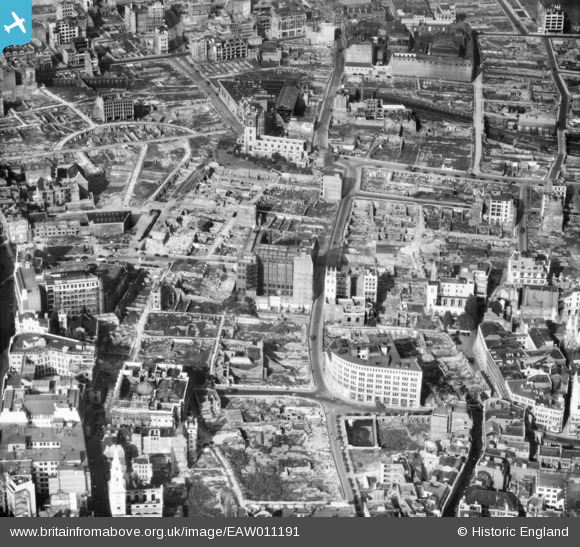
EAW011191 ENGLAND (1947). Cleared sites around Wood Street and Jewin Crescent following bomb damage, London, 1947
© Copyright OpenStreetMap contributors and licensed by the OpenStreetMap Foundation. 2025. Cartography is licensed as CC BY-SA.
Nearby Images (46)
EAW011191

EAW011115

EPW028614

EPW055300

EPW062008

EAW026314

EPW009004

EPW009002

EPW009001

EPW028613

EPW028615

EAW011369

EAW000506

EAW000508

EPW062007

EPW009005

EPW045434

EPW028612

EPW045433

EPW062011

EPW009000

EPW009003

EPW062031

EAW048555

EPW045433A

EAW000513

EAW011114

EAW021730

EAW020403

EPW055311

EPW062010

EAW000511

EAW011368
, London, 1947")
EPW028616

EAW026313

EPW062009

EAW049464
, London, 1953")
EAW018351

EPW045432

EAW011370

EAW053007

EAW053010

EAW021119

EAW000660

EPW056674

EAW053004

Details
| Title | [EAW011191] Cleared sites around Wood Street and Jewin Crescent following bomb damage, London, 1947 |
| Reference | EAW011191 |
| Date | 30-September-1947 |
| Link | |
| Place name | LONDON |
| Parish | |
| District | |
| Country | ENGLAND |
| Easting / Northing | 532302, 181488 |
| Longitude / Latitude | -0.093037844358628, 51.516319167359 |
| National Grid Reference | TQ323815 |
Pins
 Hermann the German |
Friday 25th of August 2017 06:11:08 PM | |
Hermann the German |
Friday 25th of August 2017 05:50:54 PM | |
Hermann the German |
Friday 25th of August 2017 02:27:28 PM | |
 Class31 |
Wednesday 23rd of July 2014 11:58:02 AM | |
 Alan McFaden |
Tuesday 5th of November 2013 02:14:56 PM | |
Alan McFaden |
Tuesday 5th of November 2013 02:14:14 PM |

