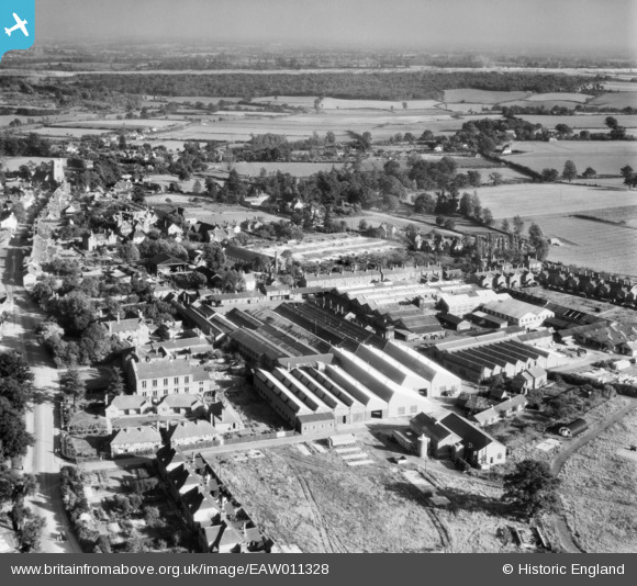
EAW011328 ENGLAND (1947). The Atlas Iron Works (Agricultural Implements), Earls Colne, from the north-west, 1947. This image was marked by Aerofilms Ltd for photo editing.
© Copyright OpenStreetMap contributors and licensed by the OpenStreetMap Foundation. 2025. Cartography is licensed as CC BY-SA.
Nearby Images (14)
Details
| Title | [EAW011328] The Atlas Iron Works (Agricultural Implements), Earls Colne, from the north-west, 1947. This image was marked by Aerofilms Ltd for photo editing. |
| Reference | EAW011328 |
| Date | 1-October-1947 |
| Link | |
| Place name | EARLS COLNE |
| Parish | EARLS COLNE |
| District | |
| Country | ENGLAND |
| Easting / Northing | 585389, 228879 |
| Longitude / Latitude | 0.69659185510484, 51.927074593924 |
| National Grid Reference | TL854289 |
Pins
 thomasmann |
Sunday 8th of June 2014 03:48:35 PM |


![[EAW011328] The Atlas Iron Works (Agricultural Implements), Earls Colne, from the north-west, 1947. This image was marked by Aerofilms Ltd for photo editing.](http://britainfromabove.org.uk/sites/all/libraries/aerofilms-images/public/100x100/EAW/011/EAW011328.jpg)
![[EAW011326] The Atlas Iron Works (Agricultural Implements), Earls Colne, 1947. This image was marked by Aerofilms Ltd for photo editing.](http://britainfromabove.org.uk/sites/all/libraries/aerofilms-images/public/100x100/EAW/011/EAW011326.jpg)
![[EAW011330] The Atlas Iron Works (Agricultural Implements), Earls Colne, 1947. This image was marked by Aerofilms Ltd for photo editing.](http://britainfromabove.org.uk/sites/all/libraries/aerofilms-images/public/100x100/EAW/011/EAW011330.jpg)
![[EAW011323] The Atlas Iron Works (Agricultural Implements) and the village, Earls Colne, 1947. This image was marked by Aerofilms Ltd for photo editing.](http://britainfromabove.org.uk/sites/all/libraries/aerofilms-images/public/100x100/EAW/011/EAW011323.jpg)
![[EAW011325] The Atlas Iron Works (Agricultural Implements), Earls Colne, 1947. This image was marked by Aerofilms Ltd for photo editing.](http://britainfromabove.org.uk/sites/all/libraries/aerofilms-images/public/100x100/EAW/011/EAW011325.jpg)
![[EAW011322] The Atlas Iron Works (Agricultural Implements), Earls Colne, 1947. This image was marked by Aerofilms Ltd for photo editing.](http://britainfromabove.org.uk/sites/all/libraries/aerofilms-images/public/100x100/EAW/011/EAW011322.jpg)
![[EAW011324] The Atlas Iron Works (Agricultural Implements) and the village, Earls Colne, 1947. This image was marked by Aerofilms Ltd for photo editing.](http://britainfromabove.org.uk/sites/all/libraries/aerofilms-images/public/100x100/EAW/011/EAW011324.jpg)
![[EAW011327] The Atlas Iron Works (Agricultural Implements), Earls Colne, 1947. This image was marked by Aerofilms Ltd for photo editing.](http://britainfromabove.org.uk/sites/all/libraries/aerofilms-images/public/100x100/EAW/011/EAW011327.jpg)
![[EAW011333] The Atlas Iron Works (Agricultural Implements), Earls Colne, 1947. This image was marked by Aerofilms Ltd for photo editing.](http://britainfromabove.org.uk/sites/all/libraries/aerofilms-images/public/100x100/EAW/011/EAW011333.jpg)
![[EAW011321] The Atlas Iron Works (Agricultural Implements), Earls Colne, 1947. This image was marked by Aerofilms Ltd for photo editing.](http://britainfromabove.org.uk/sites/all/libraries/aerofilms-images/public/100x100/EAW/011/EAW011321.jpg)
![[EAW011329] The Atlas Iron Works (Agricultural Implements), Earls Colne, from the south-west, 1947](http://britainfromabove.org.uk/sites/all/libraries/aerofilms-images/public/100x100/EAW/011/EAW011329.jpg)
![[EAW011332] The Atlas Iron Works (Agricultural Implements), Earls Colne, 1947. This image was marked by Aerofilms Ltd for photo editing.](http://britainfromabove.org.uk/sites/all/libraries/aerofilms-images/public/100x100/EAW/011/EAW011332.jpg)
![[EAW011331] The Atlas Iron Works (Agricultural Implements), Earls Colne, from the south-east, 1947. This image was marked by Aerofilms Ltd for photo editing.](http://britainfromabove.org.uk/sites/all/libraries/aerofilms-images/public/100x100/EAW/011/EAW011331.jpg)
![[EAW043692] Foundry Lane, Park Lane Close and environs, Earls Colne, 1952](http://britainfromabove.org.uk/sites/all/libraries/aerofilms-images/public/100x100/EAW/043/EAW043692.jpg)