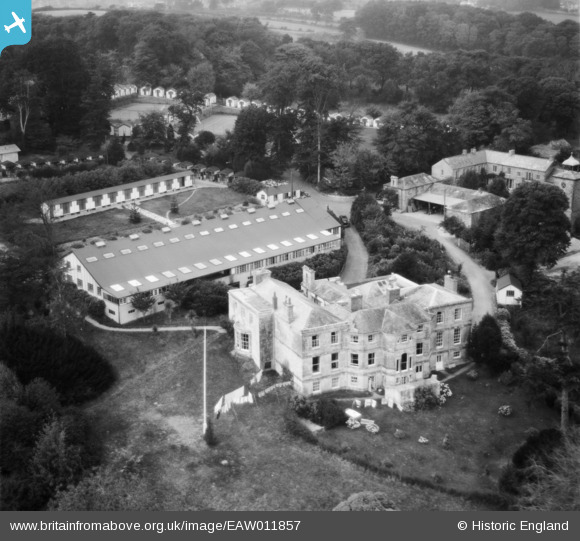
EAW011857 ENGLAND (1947). Duporth Holiday Resort including the manor house, Duporth, 1947
© Copyright OpenStreetMap contributors and licensed by the OpenStreetMap Foundation. 2024. Cartography is licensed as CC BY-SA.
Nearby Images (23)
Details
| Title | [EAW011857] Duporth Holiday Resort including the manor house, Duporth, 1947 |
| Reference | EAW011857 |
| Date | 7-October-1947 |
| Link | |
| Place name | DUPORTH |
| Parish | ST. AUSTELL BAY |
| District | |
| Country | ENGLAND |
| Easting / Northing | 203200, 51261 |
| Longitude / Latitude | -4.7653353151573, 50.32775117934 |
| National Grid Reference | SX032513 |
Pins
Be the first to add a comment to this image!
User Comment Contributions
I love the display of 1940s undies in this picture! |
 Laura Maddison |
Wednesday 14th of August 2013 03:19:19 PM |


![[EAW011857] Duporth Holiday Resort including the manor house, Duporth, 1947](http://britainfromabove.org.uk/sites/all/libraries/aerofilms-images/public/100x100/EAW/011/EAW011857.jpg)
![[EAW011855] Duporth Holiday Resort including the manor house, Duporth, 1947](http://britainfromabove.org.uk/sites/all/libraries/aerofilms-images/public/100x100/EAW/011/EAW011855.jpg)
![[EAW011859] Duporth Holiday Resort, Duporth, 1947](http://britainfromabove.org.uk/sites/all/libraries/aerofilms-images/public/100x100/EAW/011/EAW011859.jpg)
![[EAW005985] Duporth Holiday Camp, Duporth, 1947](http://britainfromabove.org.uk/sites/all/libraries/aerofilms-images/public/100x100/EAW/005/EAW005985.jpg)
![[EAW011854] Duporth Holiday Resort, Duporth, 1947](http://britainfromabove.org.uk/sites/all/libraries/aerofilms-images/public/100x100/EAW/011/EAW011854.jpg)
![[EAW005986] Duporth Holiday Camp, Duporth, 1947](http://britainfromabove.org.uk/sites/all/libraries/aerofilms-images/public/100x100/EAW/005/EAW005986.jpg)
![[EAW005988] Duporth Holiday Camp, Duporth, 1947](http://britainfromabove.org.uk/sites/all/libraries/aerofilms-images/public/100x100/EAW/005/EAW005988.jpg)
![[EAW005994] Duporth Holiday Camp, Duporth, 1947](http://britainfromabove.org.uk/sites/all/libraries/aerofilms-images/public/100x100/EAW/005/EAW005994.jpg)
![[EAW011852] Duporth Holiday Resort, Duporth, 1947](http://britainfromabove.org.uk/sites/all/libraries/aerofilms-images/public/100x100/EAW/011/EAW011852.jpg)
![[EAW011853] Duporth Holiday Resort, Duporth, 1947](http://britainfromabove.org.uk/sites/all/libraries/aerofilms-images/public/100x100/EAW/011/EAW011853.jpg)
![[EAW005987] Duporth Holiday Camp and Duporth Beach, Duporth, 1947](http://britainfromabove.org.uk/sites/all/libraries/aerofilms-images/public/100x100/EAW/005/EAW005987.jpg)
![[EAW011856] Duporth Holiday Resort, Duporth, 1947](http://britainfromabove.org.uk/sites/all/libraries/aerofilms-images/public/100x100/EAW/011/EAW011856.jpg)
![[EAW011858] Duporth Holiday Resort, Duporth, 1947](http://britainfromabove.org.uk/sites/all/libraries/aerofilms-images/public/100x100/EAW/011/EAW011858.jpg)
![[EAW005993] Duporth Holiday Camp, Duporth, 1947](http://britainfromabove.org.uk/sites/all/libraries/aerofilms-images/public/100x100/EAW/005/EAW005993.jpg)
![[EAW005990] Duporth Holiday Camp and environs, Duporth, from the north-east, 1947](http://britainfromabove.org.uk/sites/all/libraries/aerofilms-images/public/100x100/EAW/005/EAW005990.jpg)
![[EAW011847] Duporth Holiday Resort, Duporth, 1947](http://britainfromabove.org.uk/sites/all/libraries/aerofilms-images/public/100x100/EAW/011/EAW011847.jpg)
![[EAW005989] Duporth Holiday Camp and environs, Duporth, 1947](http://britainfromabove.org.uk/sites/all/libraries/aerofilms-images/public/100x100/EAW/005/EAW005989.jpg)
![[EAW011851] Duporth Holiday Resort and Du Porth Beach, Duporth, 1947](http://britainfromabove.org.uk/sites/all/libraries/aerofilms-images/public/100x100/EAW/011/EAW011851.jpg)
![[EAW011849] Duporth Holiday Camp, St Austell, 1947](http://britainfromabove.org.uk/sites/all/libraries/aerofilms-images/public/100x100/EAW/011/EAW011849.jpg)
![[EAW011848] Duporth Holiday Resort, Duporth, 1947](http://britainfromabove.org.uk/sites/all/libraries/aerofilms-images/public/100x100/EAW/011/EAW011848.jpg)
![[EAW005991] Duporth Holiday Camp, Duporth Beach and environs, Duporth, 1947](http://britainfromabove.org.uk/sites/all/libraries/aerofilms-images/public/100x100/EAW/005/EAW005991.jpg)
![[EAW011850] Duporth Holiday Camp, St Austell, 1947](http://britainfromabove.org.uk/sites/all/libraries/aerofilms-images/public/100x100/EAW/011/EAW011850.jpg)