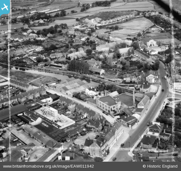
EAW011942 ENGLAND (1947). The S. C. Johnson and Son Works and the surrounding area, Yiewsley, 1947. This image was marked by Aerofilms Ltd for photo editing.
© Copyright OpenStreetMap contributors and licensed by the OpenStreetMap Foundation. 2025. Cartography is licensed as CC BY-SA.
Nearby Images (9)
Details
| Title | [EAW011942] The S. C. Johnson and Son Works and the surrounding area, Yiewsley, 1947. This image was marked by Aerofilms Ltd for photo editing. |
| Reference | EAW011942 |
| Date | 17-October-1947 |
| Link | |
| Place name | YIEWSLEY |
| Parish | |
| District | |
| Country | ENGLAND |
| Easting / Northing | 505991, 180343 |
| Longitude / Latitude | -0.47245822253732, 51.511577399154 |
| National Grid Reference | TQ060803 |
Pins
 Matt Aldred edob.mattaldred.com |
Sunday 1st of August 2021 06:32:34 PM | |
 idealjohn |
Sunday 10th of March 2019 07:31:45 PM | |
 brian |
Saturday 25th of January 2014 09:48:26 PM | |
 brian |
Monday 30th of December 2013 04:27:05 PM | |
 brian |
Monday 30th of December 2013 04:25:23 PM | |
 brian |
Monday 30th of December 2013 04:13:18 PM | |
 brian |
Monday 30th of December 2013 04:11:25 PM | |
 brian |
Monday 30th of December 2013 04:04:05 PM | |
 brian |
Monday 30th of December 2013 04:01:05 PM | |
 brian |
Monday 30th of December 2013 03:59:49 PM | |
 brian |
Monday 30th of December 2013 03:58:04 PM | |
 brian |
Monday 30th of December 2013 03:56:59 PM | |
 brian |
Monday 30th of December 2013 03:55:49 PM | |
 brian |
Monday 30th of December 2013 03:54:06 PM | |
 brian |
Monday 30th of December 2013 03:51:18 PM | |
 brian |
Monday 30th of December 2013 03:48:34 PM | |
 brian |
Monday 30th of December 2013 03:47:22 PM | |
 brian |
Monday 30th of December 2013 03:37:36 PM | |
 brian |
Monday 30th of December 2013 03:35:32 PM | |
 brian |
Monday 30th of December 2013 03:34:35 PM |


![[EAW011942] The S. C. Johnson and Son Works and the surrounding area, Yiewsley, 1947. This image was marked by Aerofilms Ltd for photo editing.](http://britainfromabove.org.uk/sites/all/libraries/aerofilms-images/public/100x100/EAW/011/EAW011942.jpg)
![[EAW011936] The S. C. Johnson and Son Works and the surrounding area, Yiewsley, 1947. This image was marked by Aerofilms Ltd for photo editing.](http://britainfromabove.org.uk/sites/all/libraries/aerofilms-images/public/100x100/EAW/011/EAW011936.jpg)
![[EAW011940] The S. C. Johnson and Son Works and the surrounding area, Yiewsley, 1947. This image was marked by Aerofilms Ltd for photo editing.](http://britainfromabove.org.uk/sites/all/libraries/aerofilms-images/public/100x100/EAW/011/EAW011940.jpg)
![[EAW011941] The S. C. Johnson and Son Works and the surrounding area, Yiewsley, 1947. This image was marked by Aerofilms Ltd for photo editing.](http://britainfromabove.org.uk/sites/all/libraries/aerofilms-images/public/100x100/EAW/011/EAW011941.jpg)
![[EPW052762] The area between Tavistock Road and Oldham Road, Yiewsley, 1937](http://britainfromabove.org.uk/sites/all/libraries/aerofilms-images/public/100x100/EPW/052/EPW052762.jpg)
![[EAW011938] The S. C. Johnson and Son Works alongside the Grand Union Canal, Yiewsley, 1947. This image was marked by Aerofilms Ltd for photo editing.](http://britainfromabove.org.uk/sites/all/libraries/aerofilms-images/public/100x100/EAW/011/EAW011938.jpg)
![[EAW011937] The S. C. Johnson and Son Works and the surrounding residential area, Yiewsley, 1947. This image was marked by Aerofilms Ltd for photo editing.](http://britainfromabove.org.uk/sites/all/libraries/aerofilms-images/public/100x100/EAW/011/EAW011937.jpg)
![[EAW011935] The S. C. Johnson and Son Works, Yiewsley, 1947. This image was marked by Aerofilms Ltd for photo editing.](http://britainfromabove.org.uk/sites/all/libraries/aerofilms-images/public/100x100/EAW/011/EAW011935.jpg)
![[EAW011939] The S. C. Johnson and Son Works and the surrounding area, Yiewsley, 1947](http://britainfromabove.org.uk/sites/all/libraries/aerofilms-images/public/100x100/EAW/011/EAW011939.jpg)