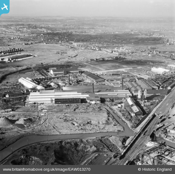
EAW013270 ENGLAND (1948). Joseph Sankey & Sons Ltd Manor Works and environs, Ettingshall, from the south-east, 1948
© Copyright OpenStreetMap contributors and licensed by the OpenStreetMap Foundation. 2025. Cartography is licensed as CC BY-SA.
Nearby Images (19)
Details
| Title | [EAW013270] Joseph Sankey & Sons Ltd Manor Works and environs, Ettingshall, from the south-east, 1948 |
| Reference | EAW013270 |
| Date | 12-February-1948 |
| Link | |
| Place name | ETTINGSHALL |
| Parish | |
| District | |
| Country | ENGLAND |
| Easting / Northing | 393446, 295860 |
| Longitude / Latitude | -2.0966897421632, 52.56017566082 |
| National Grid Reference | SO934959 |
Pins
 Matt Aldred edob.mattaldred.com |
Thursday 7th of March 2024 04:18:00 PM | |
 Matt Aldred edob.mattaldred.com |
Thursday 7th of March 2024 04:17:43 PM | |
 Martin |
Monday 24th of March 2014 06:34:17 PM | |
 Class31 |
Friday 7th of March 2014 02:09:46 PM |


![[EAW013270] Joseph Sankey & Sons Ltd Manor Works and environs, Ettingshall, from the south-east, 1948](http://britainfromabove.org.uk/sites/all/libraries/aerofilms-images/public/100x100/EAW/013/EAW013270.jpg)
![[EAW013267] Joseph Sankey & Sons Ltd Manor Works and environs, Ettingshall, 1948. This image was marked by Aerofilms Ltd for photo editing.](http://britainfromabove.org.uk/sites/all/libraries/aerofilms-images/public/100x100/EAW/013/EAW013267.jpg)
![[EAW013264] Joseph Sankey & Sons Ltd Manor Works and environs, Ettingshall, 1948. This image was marked by Aerofilms Ltd for photo editing.](http://britainfromabove.org.uk/sites/all/libraries/aerofilms-images/public/100x100/EAW/013/EAW013264.jpg)
![[EAW013263] Joseph Sankey & Sons Ltd Manor Works, Spring Vale Sidings and environs, Ettingshall, 1948](http://britainfromabove.org.uk/sites/all/libraries/aerofilms-images/public/100x100/EAW/013/EAW013263.jpg)
![[EPW050444] Joseph Sankey & Sons Ltd Manor Works (Sheet Metal), the Prior Field Iron Foundry and Deepfields Fire Brick and Clay Works, Ettingshall, 1936](http://britainfromabove.org.uk/sites/all/libraries/aerofilms-images/public/100x100/EPW/050/EPW050444.jpg)
![[EPW050446] Joseph Sankey & Sons Ltd Manor Works (Sheet Metal), the Prior Field Iron Foundry and Deepfields Fire Brick and Clay Works, Ettingshall, 1936](http://britainfromabove.org.uk/sites/all/libraries/aerofilms-images/public/100x100/EPW/050/EPW050446.jpg)
![[EPW050443] Joseph Sankey & Sons Ltd Manor Works (Sheet Metal), Ettingshall, 1936](http://britainfromabove.org.uk/sites/all/libraries/aerofilms-images/public/100x100/EPW/050/EPW050443.jpg)
![[EAW013272] Joseph Sankey & Sons Ltd Manor Works and environs, Ettingshall, 1948](http://britainfromabove.org.uk/sites/all/libraries/aerofilms-images/public/100x100/EAW/013/EAW013272.jpg)
![[EPW050448] Joseph Sankey & Sons Ltd Manor Works (Sheet Metal) and environs, Ettingshall, 1936](http://britainfromabove.org.uk/sites/all/libraries/aerofilms-images/public/100x100/EPW/050/EPW050448.jpg)
![[EAW013269] Joseph Sankey & Sons Ltd Manor Works and environs, Ettingshall, 1948](http://britainfromabove.org.uk/sites/all/libraries/aerofilms-images/public/100x100/EAW/013/EAW013269.jpg)
![[EAW013271] Joseph Sankey & Sons Ltd Manor Works, Ettingshall, 1948](http://britainfromabove.org.uk/sites/all/libraries/aerofilms-images/public/100x100/EAW/013/EAW013271.jpg)
![[EPW050447] Joseph Sankey & Sons Ltd Manor Works (Sheet Metal), Ettingshall, 1936](http://britainfromabove.org.uk/sites/all/libraries/aerofilms-images/public/100x100/EPW/050/EPW050447.jpg)
![[EAW013265] Joseph Sankey & Sons Ltd Manor Works and environs, Ettingshall, 1948](http://britainfromabove.org.uk/sites/all/libraries/aerofilms-images/public/100x100/EAW/013/EAW013265.jpg)
![[EAW013273] Joseph Sankey & Sons Ltd Manor Works and environs, Ettingshall, from the south-west, 1948](http://britainfromabove.org.uk/sites/all/libraries/aerofilms-images/public/100x100/EAW/013/EAW013273.jpg)
![[EAW001257] Birmingham Road, the Manor Sheet Metal Works and the surrounding industrial area, Ettingshall, 1946](http://britainfromabove.org.uk/sites/all/libraries/aerofilms-images/public/100x100/EAW/001/EAW001257.jpg)
![[EPW050445] Joseph Sankey & Sons Ltd Manor Works (Sheet Metal) and environs, Ettingshall, 1936](http://britainfromabove.org.uk/sites/all/libraries/aerofilms-images/public/100x100/EPW/050/EPW050445.jpg)
![[EAW013262] Joseph Sankey & Sons Ltd Manor Works and environs, Ettingshall, 1948](http://britainfromabove.org.uk/sites/all/libraries/aerofilms-images/public/100x100/EAW/013/EAW013262.jpg)
![[EAW013268] Joseph Sankey & Sons Ltd Manor Works, Ettingshall, 1948](http://britainfromabove.org.uk/sites/all/libraries/aerofilms-images/public/100x100/EAW/013/EAW013268.jpg)
![[EAW013266] Joseph Sankey & Sons Ltd Manor Works and environs, Ettingshall, 1948.](http://britainfromabove.org.uk/sites/all/libraries/aerofilms-images/public/100x100/EAW/013/EAW013266.jpg)