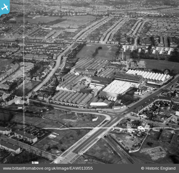
EAW013355 ENGLAND (1948). The Roneo Works, Romford, 1948. This image was marked by Aerofilms Ltd for photo editing.
© Copyright OpenStreetMap contributors and licensed by the OpenStreetMap Foundation. 2025. Cartography is licensed as CC BY-SA.
Nearby Images (12)
Details
| Title | [EAW013355] The Roneo Works, Romford, 1948. This image was marked by Aerofilms Ltd for photo editing. |
| Reference | EAW013355 |
| Date | 16-February-1948 |
| Link | |
| Place name | ROMFORD |
| Parish | |
| District | |
| Country | ENGLAND |
| Easting / Northing | 551759, 187564 |
| Longitude / Latitude | 0.18982382194498, 51.566025172956 |
| National Grid Reference | TQ518876 |
Pins
 Sparky |
Wednesday 26th of July 2017 02:51:53 PM | |
 Tommy |
Saturday 25th of February 2017 10:00:29 AM | |
 Tommy |
Saturday 25th of February 2017 09:59:00 AM | |
 Tommy |
Saturday 25th of February 2017 09:56:30 AM | |
 Tommy |
Saturday 25th of February 2017 09:55:34 AM | |
 Tommy |
Saturday 25th of February 2017 09:54:39 AM | |
 Tommy |
Saturday 25th of February 2017 09:53:38 AM |


![[EAW013355] The Roneo Works, Romford, 1948. This image was marked by Aerofilms Ltd for photo editing.](http://britainfromabove.org.uk/sites/all/libraries/aerofilms-images/public/100x100/EAW/013/EAW013355.jpg)
![[EPW001395] The Roneo Works, Romford, 1920](http://britainfromabove.org.uk/sites/all/libraries/aerofilms-images/public/100x100/EPW/001/EPW001395.jpg)
![[EAW013353] The Roneo Works, Romford, 1948. This image has been produced from a damaged negative.](http://britainfromabove.org.uk/sites/all/libraries/aerofilms-images/public/100x100/EAW/013/EAW013353.jpg)
![[EAW013352] The Roneo Works, Romford, 1948. This image has been produced from a damaged negative.](http://britainfromabove.org.uk/sites/all/libraries/aerofilms-images/public/100x100/EAW/013/EAW013352.jpg)
![[EAW013350] The Roneo Works, Romford, 1948. This image has been produced from a damaged negative.](http://britainfromabove.org.uk/sites/all/libraries/aerofilms-images/public/100x100/EAW/013/EAW013350.jpg)
![[EAW013356] The Roneo Works, Romford, 1948. This image was marked by Aerofilms Ltd for photo editing.](http://britainfromabove.org.uk/sites/all/libraries/aerofilms-images/public/100x100/EAW/013/EAW013356.jpg)
![[EAW013357] The Roneo Works, Romford, 1948. This image was marked by Aerofilms Ltd for photo editing.](http://britainfromabove.org.uk/sites/all/libraries/aerofilms-images/public/100x100/EAW/013/EAW013357.jpg)
![[EAW013348] The Roneo Works and environs, Romford, 1948. This image has been produced from a print.](http://britainfromabove.org.uk/sites/all/libraries/aerofilms-images/public/100x100/EAW/013/EAW013348.jpg)
![[EAW013354] The Roneo Works, Romford, 1948. This image was marked by Aerofilms Ltd for photo editing.](http://britainfromabove.org.uk/sites/all/libraries/aerofilms-images/public/100x100/EAW/013/EAW013354.jpg)
![[EAW013358] The Roneo Works, Romford, 1948](http://britainfromabove.org.uk/sites/all/libraries/aerofilms-images/public/100x100/EAW/013/EAW013358.jpg)
![[EAW013351] The Roneo Works, Romford, 1948. This image has been produced from a damaged negative.](http://britainfromabove.org.uk/sites/all/libraries/aerofilms-images/public/100x100/EAW/013/EAW013351.jpg)
![[EAW040960] The site of the Brooke Trading Estate, Romford, 1951. This image was marked by Aerofilms Ltd for photo editing.](http://britainfromabove.org.uk/sites/all/libraries/aerofilms-images/public/100x100/EAW/040/EAW040960.jpg)