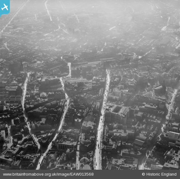
EAW013568 ENGLAND (1948). The city centre including High Street and Corporation Street, Birmingham, 1948
© Copyright OpenStreetMap contributors and licensed by the OpenStreetMap Foundation. 2025. Cartography is licensed as CC BY-SA.
Nearby Images (29)
Details
| Title | [EAW013568] The city centre including High Street and Corporation Street, Birmingham, 1948 |
| Reference | EAW013568 |
| Date | 9-March-1948 |
| Link | |
| Place name | BIRMINGHAM |
| Parish | |
| District | |
| Country | ENGLAND |
| Easting / Northing | 407149, 286863 |
| Longitude / Latitude | -1.8947258986697, 52.479276752947 |
| National Grid Reference | SP071869 |


![[EAW013568] The city centre including High Street and Corporation Street, Birmingham, 1948](http://britainfromabove.org.uk/sites/all/libraries/aerofilms-images/public/100x100/EAW/013/EAW013568.jpg)
![[EPW048093] Birmingham New Street Station, Corporation Street and the city, Birmingham, from the south-west 1935](http://britainfromabove.org.uk/sites/all/libraries/aerofilms-images/public/100x100/EPW/048/EPW048093.jpg)
![[EAW013567] The city centre including High Street and Corporation Street, Birmingham, 1948](http://britainfromabove.org.uk/sites/all/libraries/aerofilms-images/public/100x100/EAW/013/EAW013567.jpg)
![[EAW001238] New Street Railway Station, Corporation Street and the city centre, Birmingham, 1946](http://britainfromabove.org.uk/sites/all/libraries/aerofilms-images/public/100x100/EAW/001/EAW001238.jpg)
![[EPW057481] Corporation Street, King Edward House and environs, Birmingham, 1938](http://britainfromabove.org.uk/sites/all/libraries/aerofilms-images/public/100x100/EPW/057/EPW057481.jpg)
![[EAW013573] The city centre around Bull Street and Martineau Street, Birmingham, 1948](http://britainfromabove.org.uk/sites/all/libraries/aerofilms-images/public/100x100/EAW/013/EAW013573.jpg)
![[EAW013572] The city centre around Corporation Row, Birmingham, 1948](http://britainfromabove.org.uk/sites/all/libraries/aerofilms-images/public/100x100/EAW/013/EAW013572.jpg)
![[EAW026255] Snow Hill Station and the city centre, Birmingham, from the east, 1949](http://britainfromabove.org.uk/sites/all/libraries/aerofilms-images/public/100x100/EAW/026/EAW026255.jpg)
![[EAW035107] Corporation Street and environs, Birmingham, 1951](http://britainfromabove.org.uk/sites/all/libraries/aerofilms-images/public/100x100/EAW/035/EAW035107.jpg)
![[EAW001235] New Street and Snow Hill Railway Stations and the city centre, Birmingham, 1946](http://britainfromabove.org.uk/sites/all/libraries/aerofilms-images/public/100x100/EAW/001/EAW001235.jpg)
![[EAW015327] New Street Railway Station, Smithfield Market and the city centre, Birmingham, 1948. This image has been produced from a print.](http://britainfromabove.org.uk/sites/all/libraries/aerofilms-images/public/100x100/EAW/015/EAW015327.jpg)
![[EAW013571] The city centre around Corporation Row, Birmingham, 1948](http://britainfromabove.org.uk/sites/all/libraries/aerofilms-images/public/100x100/EAW/013/EAW013571.jpg)
![[EAW001237] New Street Railway Station, the Town Hall and the city centre, Birmingham, 1946](http://britainfromabove.org.uk/sites/all/libraries/aerofilms-images/public/100x100/EAW/001/EAW001237.jpg)
![[EPW053091] The area between Snow Hill Station and New Street including St Philip's Cathedral, Birmingham, 1937](http://britainfromabove.org.uk/sites/all/libraries/aerofilms-images/public/100x100/EPW/053/EPW053091.jpg)
![[EAW026254] New Street Station and the city centre, Birmingham, from the east, 1949](http://britainfromabove.org.uk/sites/all/libraries/aerofilms-images/public/100x100/EAW/026/EAW026254.jpg)
![[EAW001239] New Street Railway Station, St Philip's Cathedral and the city centre, Birmingham, 1946](http://britainfromabove.org.uk/sites/all/libraries/aerofilms-images/public/100x100/EAW/001/EAW001239.jpg)
![[EAW035108] New Street Station and environs, Birmingham, 1951](http://britainfromabove.org.uk/sites/all/libraries/aerofilms-images/public/100x100/EAW/035/EAW035108.jpg)
![[EAW036926] Lewis's Department Store on Corporation Street, Birmingham, 1951. This image has been produced from a print marked by Aerofilms Ltd for photo editing.](http://britainfromabove.org.uk/sites/all/libraries/aerofilms-images/public/100x100/EAW/036/EAW036926.jpg)
![[EAW036921] Lewis's Department Store on Corporation Street, Birmingham, 1951. This image has been produced from a print marked by Aerofilms Ltd for photo editing.](http://britainfromabove.org.uk/sites/all/libraries/aerofilms-images/public/100x100/EAW/036/EAW036921.jpg)
![[EAW036918] Lewis's Department Store on Corporation Street, Birmingham, 1951. This image has been produced from a print marked by Aerofilms Ltd for photo editing.](http://britainfromabove.org.uk/sites/all/libraries/aerofilms-images/public/100x100/EAW/036/EAW036918.jpg)
![[EAW029414] The Cathedral Church of St Philip and environs, Birmingham, 1950](http://britainfromabove.org.uk/sites/all/libraries/aerofilms-images/public/100x100/EAW/029/EAW029414.jpg)
![[EAW036925] Lewis's Department Store on Corporation Street, Birmingham, 1951. This image has been produced from a print marked by Aerofilms Ltd for photo editing.](http://britainfromabove.org.uk/sites/all/libraries/aerofilms-images/public/100x100/EAW/036/EAW036925.jpg)
![[EPW038601] New Street Station, Birmingham, 1932](http://britainfromabove.org.uk/sites/all/libraries/aerofilms-images/public/100x100/EPW/038/EPW038601.jpg)
![[EAW029415] The Cathedral Church of St Philip and environs, Birmingham, 1950](http://britainfromabove.org.uk/sites/all/libraries/aerofilms-images/public/100x100/EAW/029/EAW029415.jpg)
![[EAW036924] Lewis's Department Store on Corporation Street, Birmingham, 1951. This image has been produced from a print marked by Aerofilms Ltd for photo editing.](http://britainfromabove.org.uk/sites/all/libraries/aerofilms-images/public/100x100/EAW/036/EAW036924.jpg)
![[EPW058129] New Street Station, Birmingham, 1938](http://britainfromabove.org.uk/sites/all/libraries/aerofilms-images/public/100x100/EPW/058/EPW058129.jpg)
![[EPW005840] Birmingham New Street Station, Birmingham, 1921](http://britainfromabove.org.uk/sites/all/libraries/aerofilms-images/public/100x100/EPW/005/EPW005840.jpg)
![[EPW022586] New Street Railway Station, Birmingham, 1928](http://britainfromabove.org.uk/sites/all/libraries/aerofilms-images/public/100x100/EPW/022/EPW022586.jpg)
![[EPW005842] St Philip's Cathedral, Birmingham, 1921](http://britainfromabove.org.uk/sites/all/libraries/aerofilms-images/public/100x100/EPW/005/EPW005842.jpg)

