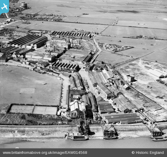
EAW014568 ENGLAND (1948). British Insulated Cables Ltd Works, Erith, 1948
© Copyright OpenStreetMap contributors and licensed by the OpenStreetMap Foundation. 2025. Cartography is licensed as CC BY-SA.
Nearby Images (48)
Details
| Title | [EAW014568] British Insulated Cables Ltd Works, Erith, 1948 |
| Reference | EAW014568 |
| Date | 16-April-1948 |
| Link | |
| Place name | ERITH |
| Parish | |
| District | |
| Country | ENGLAND |
| Easting / Northing | 550625, 179679 |
| Longitude / Latitude | 0.17010033362344, 51.495474692876 |
| National Grid Reference | TQ506797 |
Pins
Be the first to add a comment to this image!


![[EAW014568] British Insulated Cables Ltd Works, Erith, 1948](http://britainfromabove.org.uk/sites/all/libraries/aerofilms-images/public/100x100/EAW/014/EAW014568.jpg)
![[EAW014573] The British Insulated Cables Ltd Works, Erith, 1948. This image has been produced from a damaged negative.](http://britainfromabove.org.uk/sites/all/libraries/aerofilms-images/public/100x100/EAW/014/EAW014573.jpg)
![[EPW062290] Callender's Cable and Construction Company Ltd Works, Erith, 1939](http://britainfromabove.org.uk/sites/all/libraries/aerofilms-images/public/100x100/EPW/062/EPW062290.jpg)
![[EAW048353] Flooding at the British Insulated Callender's Cables Ltd Erith Works, Erith, 1953](http://britainfromabove.org.uk/sites/all/libraries/aerofilms-images/public/100x100/EAW/048/EAW048353.jpg)
![[EAW048354] Flooding at the British Insulated Callender's Cables Ltd Erith Works, Erith, 1953](http://britainfromabove.org.uk/sites/all/libraries/aerofilms-images/public/100x100/EAW/048/EAW048354.jpg)
![[EPW037310] Callender's Cable and Construction Company Ltd Works, Erith, 1932](http://britainfromabove.org.uk/sites/all/libraries/aerofilms-images/public/100x100/EPW/037/EPW037310.jpg)
![[EPW037307] Callender's Cable and Construction Company Ltd Works, Erith, 1932](http://britainfromabove.org.uk/sites/all/libraries/aerofilms-images/public/100x100/EPW/037/EPW037307.jpg)
![[EPW037909] Callenders Cable Works and environs, Erith, 1932](http://britainfromabove.org.uk/sites/all/libraries/aerofilms-images/public/100x100/EPW/037/EPW037909.jpg)
![[EPW062289] Callender's Cable and Construction Company Ltd Works, Erith, 1939. This image has been produced from a copy-negative.](http://britainfromabove.org.uk/sites/all/libraries/aerofilms-images/public/100x100/EPW/062/EPW062289.jpg)
![[EAW014566] British Insulated Cables Ltd Works, Erith, 1948. This image was marked by Aerofilms Ltd for photo editing.](http://britainfromabove.org.uk/sites/all/libraries/aerofilms-images/public/100x100/EAW/014/EAW014566.jpg)
![[EPW037904] Callenders Cable Works, Erith, 1932](http://britainfromabove.org.uk/sites/all/libraries/aerofilms-images/public/100x100/EPW/037/EPW037904.jpg)
![[EPW037312] Callender's Cable and Construction Company Ltd Works, Erith, 1932](http://britainfromabove.org.uk/sites/all/libraries/aerofilms-images/public/100x100/EPW/037/EPW037312.jpg)
![[EPW037313] Callender's Cable and Construction Company Ltd Works, Erith, 1932](http://britainfromabove.org.uk/sites/all/libraries/aerofilms-images/public/100x100/EPW/037/EPW037313.jpg)
![[EAW048357] Flooding at the British Insulated Callender's Cables Ltd Erith Works and environs, Erith, from the north-east, 1953](http://britainfromabove.org.uk/sites/all/libraries/aerofilms-images/public/100x100/EAW/048/EAW048357.jpg)
![[EPW060660] Callender's Cable and Construction Company Ltd Works, Erith, from the east, 1939](http://britainfromabove.org.uk/sites/all/libraries/aerofilms-images/public/100x100/EPW/060/EPW060660.jpg)
![[EPW060659] Callender's Cable and Construction Company Ltd Works, Erith, 1939](http://britainfromabove.org.uk/sites/all/libraries/aerofilms-images/public/100x100/EPW/060/EPW060659.jpg)
![[EPW060655] Callender's Cable and Construction Company Ltd Works, Erith, from the east, 1939](http://britainfromabove.org.uk/sites/all/libraries/aerofilms-images/public/100x100/EPW/060/EPW060655.jpg)
![[EPW060717] Callender's Cable and Construction Company Ltd Works, Erith, 1939](http://britainfromabove.org.uk/sites/all/libraries/aerofilms-images/public/100x100/EPW/060/EPW060717.jpg)
![[EPW037308] Callender's Cable and Construction Company Ltd Works, Erith, 1932](http://britainfromabove.org.uk/sites/all/libraries/aerofilms-images/public/100x100/EPW/037/EPW037308.jpg)
![[EPW060665] Callender's Cable and Construction Company Ltd Works, Erith, 1939](http://britainfromabove.org.uk/sites/all/libraries/aerofilms-images/public/100x100/EPW/060/EPW060665.jpg)
![[EAW048348] Flooding at the British Insulated Callender's Cables Ltd Erith Works and environs, Erith, 1953. This image was marked by Aerofilms Ltd for photo editing.](http://britainfromabove.org.uk/sites/all/libraries/aerofilms-images/public/100x100/EAW/048/EAW048348.jpg)
![[EAW048358] Flooding at the British Insulated Callender's Cables Ltd Erith Works, Erith, 1953](http://britainfromabove.org.uk/sites/all/libraries/aerofilms-images/public/100x100/EAW/048/EAW048358.jpg)
![[EPW060662] Callender's Cable and Construction Company Ltd Works and the River Thames, Erith, 1939](http://britainfromabove.org.uk/sites/all/libraries/aerofilms-images/public/100x100/EPW/060/EPW060662.jpg)
![[EPW062291] Callender's Cable and Construction Company Ltd Works and the Erith Oil Works, Erith, 1939](http://britainfromabove.org.uk/sites/all/libraries/aerofilms-images/public/100x100/EPW/062/EPW062291.jpg)
![[EPW060658] Callender's Cable and Construction Company Ltd Works and the River Thames, Erith, 1939](http://britainfromabove.org.uk/sites/all/libraries/aerofilms-images/public/100x100/EPW/060/EPW060658.jpg)
![[EPW060663] Callender's Cable and Construction Company Ltd Works and the River Thames, Erith, 1939](http://britainfromabove.org.uk/sites/all/libraries/aerofilms-images/public/100x100/EPW/060/EPW060663.jpg)
![[EAW014570] British Insulated Cables Ltd Works, Erith, 1948. This image was marked by Aerofilms Ltd for photo editing.](http://britainfromabove.org.uk/sites/all/libraries/aerofilms-images/public/100x100/EAW/014/EAW014570.jpg)
![[EAW048356] Flooding at the British Insulated Callender's Cables Ltd Erith Works, Erith, 1953](http://britainfromabove.org.uk/sites/all/libraries/aerofilms-images/public/100x100/EAW/048/EAW048356.jpg)
![[EPW060712] Callender's Cable and Construction Company Ltd Works, Erith, 1939](http://britainfromabove.org.uk/sites/all/libraries/aerofilms-images/public/100x100/EPW/060/EPW060712.jpg)
![[EAW048352] Flooding at the British Insulated Callender's Cables Ltd Erith Works and environs, Erith, 1953](http://britainfromabove.org.uk/sites/all/libraries/aerofilms-images/public/100x100/EAW/048/EAW048352.jpg)
![[EAW048345] Flooding at the British Insulated Callender's Cables Ltd Erith Works and environs, Erith, 1953. This image was marked by Aerofilms Ltd for photo editing.](http://britainfromabove.org.uk/sites/all/libraries/aerofilms-images/public/100x100/EAW/048/EAW048345.jpg)
![[EAW020312] The W. R. Crow & Sons Ltd Timber Yard, the River Thames and environs, Jenningtree Point, 1948. This image has been produced from a print marked by Aerofilms Ltd for photo editing.](http://britainfromabove.org.uk/sites/all/libraries/aerofilms-images/public/100x100/EAW/020/EAW020312.jpg)
![[EPW060661] Callender's Cable and Construction Company Ltd Works, Erith, 1939](http://britainfromabove.org.uk/sites/all/libraries/aerofilms-images/public/100x100/EPW/060/EPW060661.jpg)
![[EAW048346] Flooding at the British Insulated Callender's Cables Ltd Erith Works and environs, Erith, 1953. This image was marked by Aerofilms Ltd for photo editing.](http://britainfromabove.org.uk/sites/all/libraries/aerofilms-images/public/100x100/EAW/048/EAW048346.jpg)
![[EPW060652] Callender's Cable and Construction Company Ltd Works, Erith, 1939](http://britainfromabove.org.uk/sites/all/libraries/aerofilms-images/public/100x100/EPW/060/EPW060652.jpg)
![[EPW060664] Callender's Cable and Construction Company Ltd Works and the River Thames, Erith, 1939](http://britainfromabove.org.uk/sites/all/libraries/aerofilms-images/public/100x100/EPW/060/EPW060664.jpg)
![[EPW062292] Callender's Cable and Construction Company Ltd Works, Erith, 1939](http://britainfromabove.org.uk/sites/all/libraries/aerofilms-images/public/100x100/EPW/062/EPW062292.jpg)
![[EAW014567] British Insulated Cables Ltd Works, Erith, 1948. This image was marked by Aerofilms Ltd for photo editing.](http://britainfromabove.org.uk/sites/all/libraries/aerofilms-images/public/100x100/EAW/014/EAW014567.jpg)
![[EAW014572] British Insulated Cables Ltd Works, Erith, 1948. This image has been produced from a damaged negative.](http://britainfromabove.org.uk/sites/all/libraries/aerofilms-images/public/100x100/EAW/014/EAW014572.jpg)
![[EAW048351] Flooding at the British Insulated Callender's Cables Ltd Erith Works and environs, Erith, 1953](http://britainfromabove.org.uk/sites/all/libraries/aerofilms-images/public/100x100/EAW/048/EAW048351.jpg)
![[EPW060653] Callender's Cable and Construction Company Ltd Works and the River Thames, Erith, from the west, 1939](http://britainfromabove.org.uk/sites/all/libraries/aerofilms-images/public/100x100/EPW/060/EPW060653.jpg)
![[EPW060657] Callender's Cable and Construction Company Ltd Works, Erith, 1939](http://britainfromabove.org.uk/sites/all/libraries/aerofilms-images/public/100x100/EPW/060/EPW060657.jpg)
![[EPW060713] Callender's Cable and Construction Company Ltd Works, Erith, 1939](http://britainfromabove.org.uk/sites/all/libraries/aerofilms-images/public/100x100/EPW/060/EPW060713.jpg)
![[EPW060654] Callender's Cable and Construction Company Ltd Works, Erith, 1939](http://britainfromabove.org.uk/sites/all/libraries/aerofilms-images/public/100x100/EPW/060/EPW060654.jpg)
![[EPW060715] Callender's Cable and Construction Company Ltd Works, Erith, 1939](http://britainfromabove.org.uk/sites/all/libraries/aerofilms-images/public/100x100/EPW/060/EPW060715.jpg)
![[EAW048347] Flooding at the British Insulated Callender's Cables Ltd Erith Works and environs, Erith, 1953. This image was marked by Aerofilms Ltd for photo editing.](http://britainfromabove.org.uk/sites/all/libraries/aerofilms-images/public/100x100/EAW/048/EAW048347.jpg)
![[EPW060714] Callender's Cable and Construction Company Ltd Works, Erith, 1939](http://britainfromabove.org.uk/sites/all/libraries/aerofilms-images/public/100x100/EPW/060/EPW060714.jpg)
![[EAW048355] Flooding at the British Insulated Callender's Cables Ltd Erith Works, Erith, 1953](http://britainfromabove.org.uk/sites/all/libraries/aerofilms-images/public/100x100/EAW/048/EAW048355.jpg)