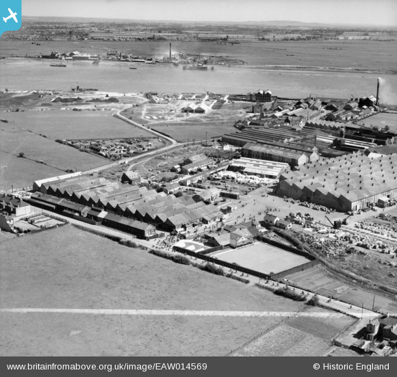
EAW014569 ENGLAND (1948). British Insulated Cables Ltd Works and environs, Erith, from the west, 1948. This image was marked by Aerofilms Ltd for photo editing.
© Copyright OpenStreetMap contributors and licensed by the OpenStreetMap Foundation. 2025. Cartography is licensed as CC BY-SA.
Nearby Images (15)
Details
| Title | [EAW014569] British Insulated Cables Ltd Works and environs, Erith, from the west, 1948. This image was marked by Aerofilms Ltd for photo editing. |
| Reference | EAW014569 |
| Date | 16-April-1948 |
| Link | |
| Place name | ERITH |
| Parish | |
| District | |
| Country | ENGLAND |
| Easting / Northing | 550127, 179576 |
| Longitude / Latitude | 0.16288717823118, 51.494681608593 |
| National Grid Reference | TQ501796 |
Pins
 Maurice |
Friday 21st of November 2014 05:59:02 PM | |
 Martin |
Tuesday 4th of March 2014 03:00:04 PM |


![[EAW014569] British Insulated Cables Ltd Works and environs, Erith, from the west, 1948. This image was marked by Aerofilms Ltd for photo editing.](http://britainfromabove.org.uk/sites/all/libraries/aerofilms-images/public/100x100/EAW/014/EAW014569.jpg)
![[EAW014574] The British Insulated Cables Ltd Works, Erith, from the west, 1948. This image has been produced from a damaged negative.](http://britainfromabove.org.uk/sites/all/libraries/aerofilms-images/public/100x100/EAW/014/EAW014574.jpg)
![[EPW037306] Callender's Cable and Construction Company Ltd Works, Erith, from the west, 1932](http://britainfromabove.org.uk/sites/all/libraries/aerofilms-images/public/100x100/EPW/037/EPW037306.jpg)
![[EPW037304] Callender's Cable and Construction Company Ltd Works, Erith, from the west, 1932](http://britainfromabove.org.uk/sites/all/libraries/aerofilms-images/public/100x100/EPW/037/EPW037304.jpg)
![[EPW037305] Callender's Cable and Construction Company Ltd Works, Erith, from the west, 1932](http://britainfromabove.org.uk/sites/all/libraries/aerofilms-images/public/100x100/EPW/037/EPW037305.jpg)
![[EAW048349] Flooding at the British Insulated Callender's Cables Ltd Erith Works, Erith, 1953](http://britainfromabove.org.uk/sites/all/libraries/aerofilms-images/public/100x100/EAW/048/EAW048349.jpg)
![[EPW060772] The River Thames from Plumstead towards Purfleet and beyond, Woolwich, from the west, 1939](http://britainfromabove.org.uk/sites/all/libraries/aerofilms-images/public/100x100/EPW/060/EPW060772.jpg)
![[EAW048350] Flooding at the British Insulated Callender's Cables Ltd Erith Works, Erith, 1953](http://britainfromabove.org.uk/sites/all/libraries/aerofilms-images/public/100x100/EAW/048/EAW048350.jpg)
![[EPW060718] Callender's Cable and Construction Company Ltd Works, Erith, 1939](http://britainfromabove.org.uk/sites/all/libraries/aerofilms-images/public/100x100/EPW/060/EPW060718.jpg)
![[EAW014571] British Insulated Cables Ltd Works, Erith, 1948. This image was marked by Aerofilms Ltd for photo editing.](http://britainfromabove.org.uk/sites/all/libraries/aerofilms-images/public/100x100/EAW/014/EAW014571.jpg)
![[EPW060716] Callender's Cable and Construction Company Ltd Works, Erith, 1939](http://britainfromabove.org.uk/sites/all/libraries/aerofilms-images/public/100x100/EPW/060/EPW060716.jpg)
![[EPW037311] Callender's Cable and Construction Company Ltd Works, Erith, 1932](http://britainfromabove.org.uk/sites/all/libraries/aerofilms-images/public/100x100/EPW/037/EPW037311.jpg)
![[EAW048359] Flooding at the British Insulated Callender's Cables Ltd Erith Works and environs, Erith, 1953](http://britainfromabove.org.uk/sites/all/libraries/aerofilms-images/public/100x100/EAW/048/EAW048359.jpg)
![[EPW060656] Callender's Cable and Construction Company Ltd Works, Erith, 1939. This image has been produced from a damaged negative.](http://britainfromabove.org.uk/sites/all/libraries/aerofilms-images/public/100x100/EPW/060/EPW060656.jpg)
![[EPW037908] Callenders Cable Works, Erith, 1932](http://britainfromabove.org.uk/sites/all/libraries/aerofilms-images/public/100x100/EPW/037/EPW037908.jpg)