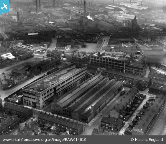
EAW014619 ENGLAND (1948). The Alliance Box Co Ltd Alliance Works, Warrington, 1948. This image has been produced from a print.
© Copyright OpenStreetMap contributors and licensed by the OpenStreetMap Foundation. 2025. Cartography is licensed as CC BY-SA.
Nearby Images (19)
Details
| Title | [EAW014619] The Alliance Box Co Ltd Alliance Works, Warrington, 1948. This image has been produced from a print. |
| Reference | EAW014619 |
| Date | 21-April-1948 |
| Link | |
| Place name | WARRINGTON |
| Parish | |
| District | |
| Country | ENGLAND |
| Easting / Northing | 360784, 388902 |
| Longitude / Latitude | -2.58981023247, 53.39522936542 |
| National Grid Reference | SJ608889 |
Pins
 redmist |
Tuesday 21st of July 2020 08:44:51 PM | |
 redmist |
Tuesday 21st of July 2020 08:44:03 PM | |
 redmist |
Tuesday 21st of July 2020 08:43:33 PM | |
 Sparky |
Thursday 27th of July 2017 11:31:20 AM |


![[EAW014619] The Alliance Box Co Ltd Alliance Works, Warrington, 1948. This image has been produced from a print.](http://britainfromabove.org.uk/sites/all/libraries/aerofilms-images/public/100x100/EAW/014/EAW014619.jpg)
![[EAW014612] The Alliance Box Co Ltd Alliance Works and environs, Warrington, 1948. This image has been produced from a print.](http://britainfromabove.org.uk/sites/all/libraries/aerofilms-images/public/100x100/EAW/014/EAW014612.jpg)
![[EAW014616] The Alliance Box Co Ltd Alliance Works and environs, Warrington, 1948](http://britainfromabove.org.uk/sites/all/libraries/aerofilms-images/public/100x100/EAW/014/EAW014616.jpg)
![[EAW050349] The Alliance Box Co Ltd Works on Orford Lane and environs, Warrington, 1953. This image was marked by Aerofilms Ltd for photo editing.](http://britainfromabove.org.uk/sites/all/libraries/aerofilms-images/public/100x100/EAW/050/EAW050349.jpg)
![[EAW014613] The Alliance Box Co Ltd Alliance Works and environs, Warrington, 1948. This image has been produced from a print marked by Aerofilms Ltd for photo editing.](http://britainfromabove.org.uk/sites/all/libraries/aerofilms-images/public/100x100/EAW/014/EAW014613.jpg)
![[EAW050347] The Alliance Box Co Ltd Works on Orford Lane and environs, Warrington, 1953. This image was marked by Aerofilms Ltd for photo editing.](http://britainfromabove.org.uk/sites/all/libraries/aerofilms-images/public/100x100/EAW/050/EAW050347.jpg)
![[EAW014618] The Alliance Box Co Ltd Alliance Works and environs, Warrington, 1948. This image has been produced from a print.](http://britainfromabove.org.uk/sites/all/libraries/aerofilms-images/public/100x100/EAW/014/EAW014618.jpg)
![[EAW050352] The Alliance Box Co Ltd Works on Orford Lane and environs, Warrington, 1953. This image was marked by Aerofilms Ltd for photo editing.](http://britainfromabove.org.uk/sites/all/libraries/aerofilms-images/public/100x100/EAW/050/EAW050352.jpg)
![[EAW050348] The Alliance Box Co Ltd Works on Orford Lane and environs, Warrington, 1953. This image was marked by Aerofilms Ltd for photo editing.](http://britainfromabove.org.uk/sites/all/libraries/aerofilms-images/public/100x100/EAW/050/EAW050348.jpg)
![[EAW014615] The Alliance Box Co Ltd Alliance Works, Warrington, 1948. This image has been produced from a print.](http://britainfromabove.org.uk/sites/all/libraries/aerofilms-images/public/100x100/EAW/014/EAW014615.jpg)
![[EAW014617] The Alliance Box Co Ltd Alliance Works and environs, Warrington, 1948](http://britainfromabove.org.uk/sites/all/libraries/aerofilms-images/public/100x100/EAW/014/EAW014617.jpg)
![[EAW050345] The Alliance Box Co Ltd Works on Orford Lane and environs, Warrington, 1953. This image was marked by Aerofilms Ltd for photo editing.](http://britainfromabove.org.uk/sites/all/libraries/aerofilms-images/public/100x100/EAW/050/EAW050345.jpg)
![[EAW014622] The Alliance Box Co Ltd Alliance Works and environs, Warrington, 1948](http://britainfromabove.org.uk/sites/all/libraries/aerofilms-images/public/100x100/EAW/014/EAW014622.jpg)
![[EAW014621] The Alliance Box Co Ltd Alliance Works and environs, Warrington, from the north-east, 1948. This image has been produced from a print marked by Aerofilms Ltd for photo editing.](http://britainfromabove.org.uk/sites/all/libraries/aerofilms-images/public/100x100/EAW/014/EAW014621.jpg)
![[EAW050351] The Alliance Box Co Ltd Works on Orford Lane and environs, Warrington, 1953. This image was marked by Aerofilms Ltd for photo editing.](http://britainfromabove.org.uk/sites/all/libraries/aerofilms-images/public/100x100/EAW/050/EAW050351.jpg)
![[EAW014614] The Alliance Box Co Ltd Alliance Works and environs, Warrington, 1948](http://britainfromabove.org.uk/sites/all/libraries/aerofilms-images/public/100x100/EAW/014/EAW014614.jpg)
![[EAW050350] The Alliance Box Co Ltd Works on Orford Lane and environs, Warrington, 1953. This image was marked by Aerofilms Ltd for photo editing.](http://britainfromabove.org.uk/sites/all/libraries/aerofilms-images/public/100x100/EAW/050/EAW050350.jpg)
![[EAW050346] The Alliance Box Co Ltd Works on Orford Lane and environs, Warrington, 1953. This image was marked by Aerofilms Ltd for photo editing.](http://britainfromabove.org.uk/sites/all/libraries/aerofilms-images/public/100x100/EAW/050/EAW050346.jpg)
![[EAW014620] The Alliance Box Co Ltd Alliance Works and environs, Warrington, 1948](http://britainfromabove.org.uk/sites/all/libraries/aerofilms-images/public/100x100/EAW/014/EAW014620.jpg)