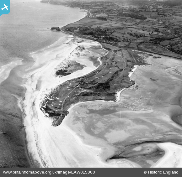
EAW015000 ENGLAND (1948). Warren Golf Course, Dawlish Warren, 1948. This image has been produced from a print.
© Copyright OpenStreetMap contributors and licensed by the OpenStreetMap Foundation. 2024. Cartography is licensed as CC BY-SA.
Details
| Title | [EAW015000] Warren Golf Course, Dawlish Warren, 1948. This image has been produced from a print. |
| Reference | EAW015000 |
| Date | 27-April-1948 |
| Link | |
| Place name | DAWLISH WARREN |
| Parish | DAWLISH |
| District | |
| Country | ENGLAND |
| Easting / Northing | 298697, 79411 |
| Longitude / Latitude | -3.4317340008785, 50.605026549068 |
| National Grid Reference | SX987794 |
Pins
 redmist |
Friday 10th of July 2020 09:14:54 PM | |
 redmist |
Friday 10th of July 2020 09:14:02 PM | |
 redmist |
Friday 10th of July 2020 09:12:55 PM | |
 redmist |
Friday 10th of July 2020 09:11:51 PM | |
 redmist |
Friday 10th of July 2020 09:11:01 PM | |
 redmist |
Friday 10th of July 2020 09:10:21 PM | |
 redmist |
Friday 10th of July 2020 09:09:22 PM | |
 redmist |
Friday 10th of July 2020 09:08:19 PM | |
 redmist |
Friday 10th of July 2020 09:07:30 PM | |
 redmist |
Friday 10th of July 2020 09:06:48 PM | |
 redmist |
Friday 10th of July 2020 09:04:58 PM | |
 cptpies |
Tuesday 31st of March 2015 11:33:04 AM | |
 cptpies |
Tuesday 31st of March 2015 11:32:35 AM | |
 cptpies |
Tuesday 31st of March 2015 11:31:55 AM |
User Comment Contributions
 cptpies |
Tuesday 31st of March 2015 11:34:46 AM |


![[EAW015000] Warren Golf Course, Dawlish Warren, 1948. This image has been produced from a print.](http://britainfromabove.org.uk/sites/all/libraries/aerofilms-images/public/100x100/EAW/015/EAW015000.jpg)
![[EAW014999] Warren golf course, Dawlish Warren, 1948](http://britainfromabove.org.uk/sites/all/libraries/aerofilms-images/public/100x100/EAW/014/EAW014999.jpg)
