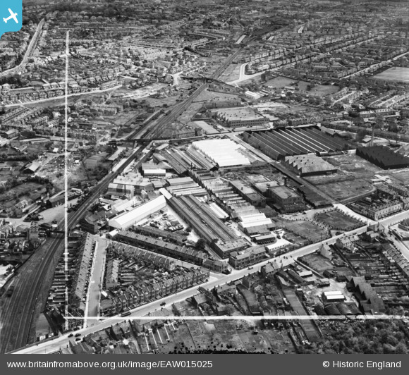
EAW015025 ENGLAND (1948). Factories off Lodge Causeway and Goodneston Road, Fishponds, 1948. This image image was marked by Aerofilms Ltd for photo editing.
© Copyright OpenStreetMap contributors and licensed by the OpenStreetMap Foundation. 2025. Cartography is licensed as CC BY-SA.
Nearby Images (29)
Details
| Title | [EAW015025] Factories off Lodge Causeway and Goodneston Road, Fishponds, 1948. This image image was marked by Aerofilms Ltd for photo editing. |
| Reference | EAW015025 |
| Date | 27-April-1948 |
| Link | |
| Place name | FISHPONDS |
| Parish | |
| District | |
| Country | ENGLAND |
| Easting / Northing | 363252, 175439 |
| Longitude / Latitude | -2.5291901626945, 51.476230215116 |
| National Grid Reference | ST633754 |
Pins
 Class31 |
Saturday 22nd of March 2014 06:09:40 PM | |
 Class31 |
Friday 28th of February 2014 03:46:01 PM | |
 Class31 |
Friday 28th of February 2014 09:55:05 AM | |
 Class31 |
Friday 28th of February 2014 09:47:37 AM | |
 Horace |
Wednesday 26th of February 2014 06:19:19 PM | |
 Horace |
Wednesday 26th of February 2014 06:17:52 PM | |
 Horace |
Wednesday 26th of February 2014 06:17:04 PM |


![[EAW015025] Factories off Lodge Causeway and Goodneston Road, Fishponds, 1948. This image image was marked by Aerofilms Ltd for photo editing.](http://britainfromabove.org.uk/sites/all/libraries/aerofilms-images/public/100x100/EAW/015/EAW015025.jpg)
![[EAW005355] The Graydon Engineering and Welding Co Ltd Works and the surrounding area, Fishponds, 1947](http://britainfromabove.org.uk/sites/all/libraries/aerofilms-images/public/100x100/EAW/005/EAW005355.jpg)
![[EAW005364] The Graydon Engineering and Welding Co Ltd Works, Lodge Causeway and the surrounding area, Fishponds, 1947](http://britainfromabove.org.uk/sites/all/libraries/aerofilms-images/public/100x100/EAW/005/EAW005364.jpg)
![[EAW015029] Factories off Lodge Causeway and Goodneston Road, Fishponds, 1948. This image was marked by Aerofilms Ltd for photo editing.](http://britainfromabove.org.uk/sites/all/libraries/aerofilms-images/public/100x100/EAW/015/EAW015029.jpg)
![[EAW015027] Factories off Lodge Causeway and Goodneston Road, Fishponds, 1948. This image was marked by Aerofilms Ltd for photo editing.](http://britainfromabove.org.uk/sites/all/libraries/aerofilms-images/public/100x100/EAW/015/EAW015027.jpg)
![[EAW005356] The Graydon Engineering and Welding Co Ltd Works and the surrounding industrial area, Fishponds, 1947](http://britainfromabove.org.uk/sites/all/libraries/aerofilms-images/public/100x100/EAW/005/EAW005356.jpg)
![[EAW015028] Factories off Lodge Causeway and Goodneston Road, Fishponds, 1948. This image was marked by Aerofilms Ltd for photo editing.](http://britainfromabove.org.uk/sites/all/libraries/aerofilms-images/public/100x100/EAW/015/EAW015028.jpg)
![[EPW014738] Parnall & Sons Ltd Shop Fittings Factory and environs, Hillfields, 1926. This image has been produced from a print.](http://britainfromabove.org.uk/sites/all/libraries/aerofilms-images/public/100x100/EPW/014/EPW014738.jpg)
![[EAW005360] The Graydon Engineering and Welding Co Ltd Works and the surrounding area, Fishponds, 1947](http://britainfromabove.org.uk/sites/all/libraries/aerofilms-images/public/100x100/EAW/005/EAW005360.jpg)
![[EAW005358] The Graydon Engineering and Welding Co Ltd Works and the surrounding area, Fishponds, 1947](http://britainfromabove.org.uk/sites/all/libraries/aerofilms-images/public/100x100/EAW/005/EAW005358.jpg)
![[EAW005352] The Graydon Engineering and Welding Co Ltd Works and the surrounding industrial area, Fishponds, 1947](http://britainfromabove.org.uk/sites/all/libraries/aerofilms-images/public/100x100/EAW/005/EAW005352.jpg)
![[EAW005361] The Graydon Engineering and Welding Co Ltd Works and the surrounding area, Fishponds, 1947](http://britainfromabove.org.uk/sites/all/libraries/aerofilms-images/public/100x100/EAW/005/EAW005361.jpg)
![[EAW015023] Factories off Lodge Causeway and Goodneston Road, Fishponds, 1948. This image has been produced from a damaged negative.](http://britainfromabove.org.uk/sites/all/libraries/aerofilms-images/public/100x100/EAW/015/EAW015023.jpg)
![[EAW005350] The Graydon Engineering and Welding Co Ltd Works and the surrounding industrial area, Fishponds, 1947](http://britainfromabove.org.uk/sites/all/libraries/aerofilms-images/public/100x100/EAW/005/EAW005350.jpg)
![[EAW005351] The Graydon Engineering and Welding Co Ltd Works and housing off Justice Road, Fishponds, 1947](http://britainfromabove.org.uk/sites/all/libraries/aerofilms-images/public/100x100/EAW/005/EAW005351.jpg)
![[EAW005363] The Graydon Engineering and Welding Co Ltd Works, Lodge Causeway and the surrounding area, Fishponds, 1947](http://britainfromabove.org.uk/sites/all/libraries/aerofilms-images/public/100x100/EAW/005/EAW005363.jpg)
![[EAW005353] The Graydon Engineering and Welding Co Ltd Works, Fishponds, 1947](http://britainfromabove.org.uk/sites/all/libraries/aerofilms-images/public/100x100/EAW/005/EAW005353.jpg)
![[EAW005362] The Graydon Engineering and Welding Co Ltd Works and the surrounding area, Fishponds, 1947](http://britainfromabove.org.uk/sites/all/libraries/aerofilms-images/public/100x100/EAW/005/EAW005362.jpg)
![[EAW005357] The Graydon Engineering and Welding Co Ltd Works and the surrounding area, Fishponds, 1947](http://britainfromabove.org.uk/sites/all/libraries/aerofilms-images/public/100x100/EAW/005/EAW005357.jpg)
![[EAW005359] The Graydon Engineering and Welding Co Ltd Works and the surrounding area, Fishponds, 1947](http://britainfromabove.org.uk/sites/all/libraries/aerofilms-images/public/100x100/EAW/005/EAW005359.jpg)
![[EAW015024] Factories off Lodge Causeway and Goodneston Road, Fishponds, 1948. This image was marked by Aerofilms Ltd for photo editing.](http://britainfromabove.org.uk/sites/all/libraries/aerofilms-images/public/100x100/EAW/015/EAW015024.jpg)
![[EAW015026] Factories off Lodge Causeway and Goodneston Road, Fishponds, from the south-west, 1948. This image was marked by Aerofilms Ltd for photo editing.](http://britainfromabove.org.uk/sites/all/libraries/aerofilms-images/public/100x100/EAW/015/EAW015026.jpg)
![[EPW014739] Parnall & Sons Ltd Shop Fittings Factory and environs, Hillfields, 1926. This image has been produced from a print affected by flare.](http://britainfromabove.org.uk/sites/all/libraries/aerofilms-images/public/100x100/EPW/014/EPW014739.jpg)
![[EAW005354] The Graydon Engineering and Welding Co Ltd Works, Fishponds, 1947](http://britainfromabove.org.uk/sites/all/libraries/aerofilms-images/public/100x100/EAW/005/EAW005354.jpg)
![[EAW032266] Lodge Causeway, the E. S. & A. Robinson Ltd Factory on Filwood Road and environs, Hillfields, 1950. This image was marked by Aerofilms Ltd for photo editing.](http://britainfromabove.org.uk/sites/all/libraries/aerofilms-images/public/100x100/EAW/032/EAW032266.jpg)
![[EAW032262] The E. S. & A. Robinson Ltd Factory on Filwood Road and environs, Hillfields, 1950. This image was marked by Aerofilms Ltd for photo editing.](http://britainfromabove.org.uk/sites/all/libraries/aerofilms-images/public/100x100/EAW/032/EAW032262.jpg)
![[EAW032269] The E. S. & A. Robinson Ltd Factory on Filwood Road and environs, Hillfields, 1950. This image was marked by Aerofilms Ltd for photo editing.](http://britainfromabove.org.uk/sites/all/libraries/aerofilms-images/public/100x100/EAW/032/EAW032269.jpg)
![[EAW032264] The E. S. & A. Robinson Ltd Factory on Filwood Road and environs, Hillfields, 1950. This image was marked by Aerofilms Ltd for photo editing.](http://britainfromabove.org.uk/sites/all/libraries/aerofilms-images/public/100x100/EAW/032/EAW032264.jpg)
![[EAW032263] The E. S. & A. Robinson Ltd Factory on Filwood Road and environs, Hillfields, 1950. This image was marked by Aerofilms Ltd for photo editing.](http://britainfromabove.org.uk/sites/all/libraries/aerofilms-images/public/100x100/EAW/032/EAW032263.jpg)