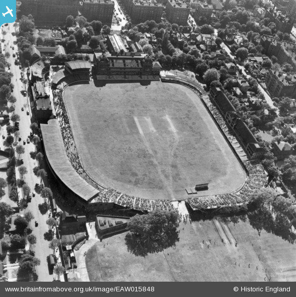
EAW015848 ENGLAND (1948). Lord's Cricket Ground, St John's Wood, 1948. This image has been produced from a print.
© Copyright OpenStreetMap contributors and licensed by the OpenStreetMap Foundation. 2025. Cartography is licensed as CC BY-SA.
Nearby Images (33)
Details
| Title | [EAW015848] Lord's Cricket Ground, St John's Wood, 1948. This image has been produced from a print. |
| Reference | EAW015848 |
| Date | 19-May-1948 |
| Link | |
| Place name | ST JOHN'S WOOD |
| Parish | |
| District | |
| Country | ENGLAND |
| Easting / Northing | 526865, 182753 |
| Longitude / Latitude | -0.17090570703367, 51.528936274336 |
| National Grid Reference | TQ269828 |
Pins
Be the first to add a comment to this image!


![[EAW015848] Lord's Cricket Ground, St John's Wood, 1948. This image has been produced from a print.](http://britainfromabove.org.uk/sites/all/libraries/aerofilms-images/public/100x100/EAW/015/EAW015848.jpg)
![[EPW006155] Lord's Cricket Ground, St John's Wood, 1921](http://britainfromabove.org.uk/sites/all/libraries/aerofilms-images/public/100x100/EPW/006/EPW006155.jpg)
![[EPW006684] St John's Wood, probably 2nd Ashes Test at Lords, 1921](http://britainfromabove.org.uk/sites/all/libraries/aerofilms-images/public/100x100/EPW/006/EPW006684.jpg)
![[EPW006681] St John's Wood, probably 2nd Ashes Test at Lords, 1921](http://britainfromabove.org.uk/sites/all/libraries/aerofilms-images/public/100x100/EPW/006/EPW006681.jpg)
![[EPW006688] St John's Wood, probably 2nd Ashes Test at Lords, 1921](http://britainfromabove.org.uk/sites/all/libraries/aerofilms-images/public/100x100/EPW/006/EPW006688.jpg)
![[EAW030528] St John's Wood, a test match (England vs West Indies) underway at Lord's Cricket Ground, 1950](http://britainfromabove.org.uk/sites/all/libraries/aerofilms-images/public/100x100/EAW/030/EAW030528.jpg)
![[EPW031880] Regents Parks and environs, Regent's Park, 1930](http://britainfromabove.org.uk/sites/all/libraries/aerofilms-images/public/100x100/EPW/031/EPW031880.jpg)
![[EAW006465] Lord's Cricket Ground, St John's Wood, 1947](http://britainfromabove.org.uk/sites/all/libraries/aerofilms-images/public/100x100/EAW/006/EAW006465.jpg)
![[EPW006686] St John's Wood, probably 2nd Ashes Test at Lords, 1921](http://britainfromabove.org.uk/sites/all/libraries/aerofilms-images/public/100x100/EPW/006/EPW006686.jpg)
![[EPW006682] St John's Wood, probably 2nd Ashes Test at Lords, 1921](http://britainfromabove.org.uk/sites/all/libraries/aerofilms-images/public/100x100/EPW/006/EPW006682.jpg)
![[EAW006466] Lord's Cricket Ground, St John's Wood, 1947](http://britainfromabove.org.uk/sites/all/libraries/aerofilms-images/public/100x100/EAW/006/EAW006466.jpg)
![[EPW006683] St John's Wood, probably 2nd Ashes Test at Lords, 1921](http://britainfromabove.org.uk/sites/all/libraries/aerofilms-images/public/100x100/EPW/006/EPW006683.jpg)
![[EPW039574] Lord's Cricket Ground and environs, St John's Wood, 1932](http://britainfromabove.org.uk/sites/all/libraries/aerofilms-images/public/100x100/EPW/039/EPW039574.jpg)
![[EPW006687] St John's Wood, probably 2nd Ashes Test at Lords, 1921](http://britainfromabove.org.uk/sites/all/libraries/aerofilms-images/public/100x100/EPW/006/EPW006687.jpg)
![[EPW015772] Lord's Cricket Ground, St John's Wood, 1926](http://britainfromabove.org.uk/sites/all/libraries/aerofilms-images/public/100x100/EPW/015/EPW015772.jpg)
![[EAW006464] Lord's Cricket Ground, St John's Wood, 1947](http://britainfromabove.org.uk/sites/all/libraries/aerofilms-images/public/100x100/EAW/006/EAW006464.jpg)
![[EAW030526] St John's Wood, a test match (England vs West Indies) underway at Lord's Cricket Ground, 1950](http://britainfromabove.org.uk/sites/all/libraries/aerofilms-images/public/100x100/EAW/030/EAW030526.jpg)
![[EAW030527] St John's Wood, a test match (England vs West Indies) underway at Lord's Cricket Ground, 1950](http://britainfromabove.org.uk/sites/all/libraries/aerofilms-images/public/100x100/EAW/030/EAW030527.jpg)
![[EAW015849] Lord's Cricket Ground, St John's Wood, 1948. This image has been produced from a print.](http://britainfromabove.org.uk/sites/all/libraries/aerofilms-images/public/100x100/EAW/015/EAW015849.jpg)
![[EAW024223] Lord's Cricket Ground, Day Two of the Second Test of the New Zealand Tour of England, 1949](http://britainfromabove.org.uk/sites/all/libraries/aerofilms-images/public/100x100/EAW/024/EAW024223.jpg)
![[EPW006685] St John's Wood, probably 2nd Ashes Test at Lords, 1921](http://britainfromabove.org.uk/sites/all/libraries/aerofilms-images/public/100x100/EPW/006/EPW006685.jpg)
![[EAW024225] Lord's Cricket Ground, Day Two of the Second Test of the New Zealand Tour of England, 1949](http://britainfromabove.org.uk/sites/all/libraries/aerofilms-images/public/100x100/EAW/024/EAW024225.jpg)
![[EPW021968] Lord's Cricket Ground and surroundings, St John's Wood, 1928](http://britainfromabove.org.uk/sites/all/libraries/aerofilms-images/public/100x100/EPW/021/EPW021968.jpg)
![[EAW024224] Lord's Cricket Ground, Day Two of the Second Test of the New Zealand Tour of England, 1949](http://britainfromabove.org.uk/sites/all/libraries/aerofilms-images/public/100x100/EAW/024/EAW024224.jpg)
![[EPW021969] Lord's Cricket Ground and surroundings, St John's Wood, 1928](http://britainfromabove.org.uk/sites/all/libraries/aerofilms-images/public/100x100/EPW/021/EPW021969.jpg)
![[EAW018353] Lord's Cricket Ground, Wellington Road and environs, St John's Wood, from the south-east, 1948. This image has been produced from a print.](http://britainfromabove.org.uk/sites/all/libraries/aerofilms-images/public/100x100/EAW/018/EAW018353.jpg)
![[EAW044241] Lord's Cricket Ground and the surrounding area, St John's Wood, 1952](http://britainfromabove.org.uk/sites/all/libraries/aerofilms-images/public/100x100/EAW/044/EAW044241.jpg)
![[EPW009093] Lord's Cricket Ground and environs, St John's Wood, 1923](http://britainfromabove.org.uk/sites/all/libraries/aerofilms-images/public/100x100/EPW/009/EPW009093.jpg)
![[EPW009007] Power Station on Regents Canal and Lord's Cricket Ground, St John's Wood, 1923. This image has been produced from a print.](http://britainfromabove.org.uk/sites/all/libraries/aerofilms-images/public/100x100/EPW/009/EPW009007.jpg)
![[EPW009008] Power Station on Regents Canal and Lord's Cricket Ground, St John's Wood, 1923. This image has been produced from a print.](http://britainfromabove.org.uk/sites/all/libraries/aerofilms-images/public/100x100/EPW/009/EPW009008.jpg)
![[EAW044240] Lord's Cricket Ground and the surrounding area, St John's Wood, 1952](http://britainfromabove.org.uk/sites/all/libraries/aerofilms-images/public/100x100/EAW/044/EAW044240.jpg)
![[EPW009006] Power Station on Regents Canal and Lord's Cricket Ground, St John's Wood, 1923](http://britainfromabove.org.uk/sites/all/libraries/aerofilms-images/public/100x100/EPW/009/EPW009006.jpg)
![[EPW005641] St John's Chapel Grave Yard and Lord's Cricket Ground, St John's Wood, 1921](http://britainfromabove.org.uk/sites/all/libraries/aerofilms-images/public/100x100/EPW/005/EPW005641.jpg)