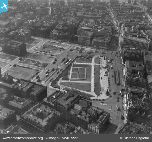
EAW015999 ENGLAND (1948). Piccadilly Gardens and environs, Manchester, 1948. This image has been produced from a print.
© Copyright OpenStreetMap contributors and licensed by the OpenStreetMap Foundation. 2025. Cartography is licensed as CC BY-SA.
Nearby Images (15)
Details
| Title | [EAW015999] Piccadilly Gardens and environs, Manchester, 1948. This image has been produced from a print. |
| Reference | EAW015999 |
| Date | 19-May-1948 |
| Link | |
| Place name | MANCHESTER |
| Parish | |
| District | |
| Country | ENGLAND |
| Easting / Northing | 384347, 398245 |
| Longitude / Latitude | -2.235892202337, 53.480442648557 |
| National Grid Reference | SJ843982 |
Pins
 Mikeya |
Tuesday 21st of May 2019 11:48:37 PM | |
 Mikeya |
Tuesday 21st of May 2019 11:40:20 PM | |
 Mikeya |
Tuesday 21st of May 2019 11:39:43 PM | |
 Mikeya |
Tuesday 21st of May 2019 11:39:06 PM | |
 Mikeya |
Tuesday 21st of May 2019 11:34:13 PM |


![[EAW015999] Piccadilly Gardens and environs, Manchester, 1948. This image has been produced from a print.](http://britainfromabove.org.uk/sites/all/libraries/aerofilms-images/public/100x100/EAW/015/EAW015999.jpg)
![[EAW050212] Piccadilly Gardens and environs, Manchester, 1953](http://britainfromabove.org.uk/sites/all/libraries/aerofilms-images/public/100x100/EAW/050/EAW050212.jpg)
![[EPW055079] Piccadilly Gardens and environs, Manchester, 1937](http://britainfromabove.org.uk/sites/all/libraries/aerofilms-images/public/100x100/EPW/055/EPW055079.jpg)
![[EAW038397] Piccadilly Gardens and the city, Manchester, from the north-west, 1951. This image has been produced from a damaged negative.](http://britainfromabove.org.uk/sites/all/libraries/aerofilms-images/public/100x100/EAW/038/EAW038397.jpg)
![[EAW050213] Piccadilly Gardens and environs, Manchester, 1953](http://britainfromabove.org.uk/sites/all/libraries/aerofilms-images/public/100x100/EAW/050/EAW050213.jpg)
![[EAW038399] Piccadilly Gardens and the city, Manchester, from the west, 1951](http://britainfromabove.org.uk/sites/all/libraries/aerofilms-images/public/100x100/EAW/038/EAW038399.jpg)
![[EPW041553] Piccadilly Gardens, the Central Public Library and the city centre, Manchester, 1933](http://britainfromabove.org.uk/sites/all/libraries/aerofilms-images/public/100x100/EPW/041/EPW041553.jpg)
![[EPW019092] Lewis's Department Store and environs, Manchester, 1927. This image has been produced from a copy-negative.](http://britainfromabove.org.uk/sites/all/libraries/aerofilms-images/public/100x100/EPW/019/EPW019092.jpg)
![[EPW045990] Piccadilly Gardens and environs, Manchester, 1934](http://britainfromabove.org.uk/sites/all/libraries/aerofilms-images/public/100x100/EPW/045/EPW045990.jpg)
![[EPW055080] The Central Library, Mosley Street and environs, Manchester, 1937](http://britainfromabove.org.uk/sites/all/libraries/aerofilms-images/public/100x100/EPW/055/EPW055080.jpg)
![[EPW019135] Lewis's Department Store, Manchester, 1927](http://britainfromabove.org.uk/sites/all/libraries/aerofilms-images/public/100x100/EPW/019/EPW019135.jpg)
![[EPW019136] Lewis's Department Store and environs, Manchester, 1927](http://britainfromabove.org.uk/sites/all/libraries/aerofilms-images/public/100x100/EPW/019/EPW019136.jpg)
![[EPW055069] Piccadilly Gardens and the city, Manchester, 1937](http://britainfromabove.org.uk/sites/all/libraries/aerofilms-images/public/100x100/EPW/055/EPW055069.jpg)
![[EPW045989] The city centre, Manchester, from the south-east, 1934](http://britainfromabove.org.uk/sites/all/libraries/aerofilms-images/public/100x100/EPW/045/EPW045989.jpg)
![[EPW019094] Manchester City Police Courts on Minshull Street and environs, Manchester, 1927. This image has been produced from a copy-negative.](http://britainfromabove.org.uk/sites/all/libraries/aerofilms-images/public/100x100/EPW/019/EPW019094.jpg)
