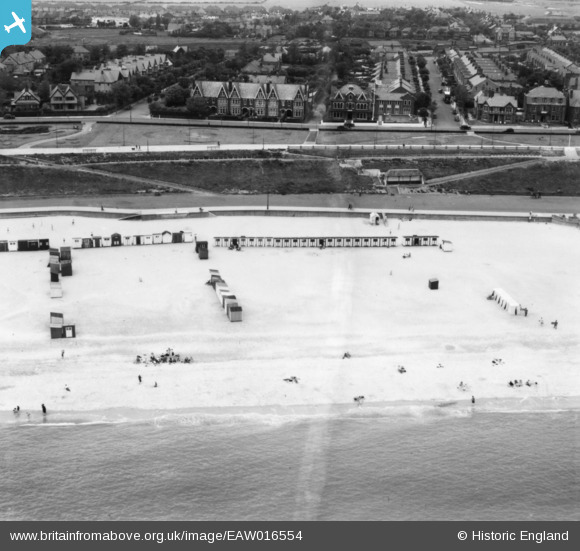
EAW016554 ENGLAND (1948). Beach huts near the shelter on Lower Esplanade and Marine Parade, Gorleston-on-Sea, 1948. This image has been produced from a print.
© Copyright OpenStreetMap contributors and licensed by the OpenStreetMap Foundation. 2025. Cartography is licensed as CC BY-SA.
Nearby Images (10)
Details
| Title | [EAW016554] Beach huts near the shelter on Lower Esplanade and Marine Parade, Gorleston-on-Sea, 1948. This image has been produced from a print. |
| Reference | EAW016554 |
| Date | 14-June-1948 |
| Link | |
| Place name | GORLESTON-ON-SEA |
| Parish | |
| District | |
| Country | ENGLAND |
| Easting / Northing | 652979, 303266 |
| Longitude / Latitude | 1.7334905103804, 52.567920134299 |
| National Grid Reference | TG530033 |
Pins
 redmist |
Tuesday 18th of January 2022 09:35:28 AM |


![[EAW016554] Beach huts near the shelter on Lower Esplanade and Marine Parade, Gorleston-on-Sea, 1948. This image has been produced from a print.](http://britainfromabove.org.uk/sites/all/libraries/aerofilms-images/public/100x100/EAW/016/EAW016554.jpg)
![[EAW016552] The Model Yacht Pond, Lower Esplanade and Marine Parade, Gorleston-on-Sea, 1948. This image has been produced from a damaged negative.](http://britainfromabove.org.uk/sites/all/libraries/aerofilms-images/public/100x100/EAW/016/EAW016552.jpg)
![[EAW016553] The Gables Hotel on Marine Parade and beach huts near the shelter on Lower Esplanade, Gorleston-on-Sea, 1948. This image has been produced from a print.](http://britainfromabove.org.uk/sites/all/libraries/aerofilms-images/public/100x100/EAW/016/EAW016553.jpg)
![[EPW007013] Marine Parade, Gorleston-on-Sea, 1921](http://britainfromabove.org.uk/sites/all/libraries/aerofilms-images/public/100x100/EPW/007/EPW007013.jpg)
![[EPW007012] Marine Parade, Gorleston-on-Sea, 1921](http://britainfromabove.org.uk/sites/all/libraries/aerofilms-images/public/100x100/EPW/007/EPW007012.jpg)
![[EAW016548] The Gables Hotel on Marine Parade, Gorleston-on-Sea, 1948. This image has been produced from a damaged negative.](http://britainfromabove.org.uk/sites/all/libraries/aerofilms-images/public/100x100/EAW/016/EAW016548.jpg)
![[EAW016550] The Gables Hotel on Marine Parade (site of) and the Model Yacht Pond, Gorleston-on-Sea, 1948. This image has been produced from a damaged negative.](http://britainfromabove.org.uk/sites/all/libraries/aerofilms-images/public/100x100/EAW/016/EAW016550.jpg)
![[EAW016549] The Gables Hotel on Marine Parade, Gorleston-on-Sea, 1948. This image has been produced from a damaged negative.](http://britainfromabove.org.uk/sites/all/libraries/aerofilms-images/public/100x100/EAW/016/EAW016549.jpg)
![[EAW016551] The Gables Hotel on Marine Parade, Gorleston-on-Sea, 1948. This image has been produced from a damaged negative.](http://britainfromabove.org.uk/sites/all/libraries/aerofilms-images/public/100x100/EAW/016/EAW016551.jpg)
![[EPW007005] Pier Gardens and environs, Gorleston-on-Sea, 1921. This image has been produced from a copy-negative.](http://britainfromabove.org.uk/sites/all/libraries/aerofilms-images/public/100x100/EPW/007/EPW007005.jpg)