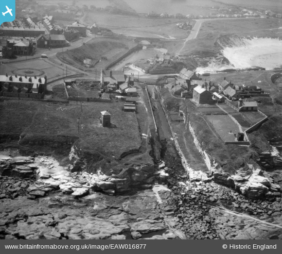
EAW016877 ENGLAND (1948). Seaton Sluice Harbour, Seaton Sluice, 1948
© Copyright OpenStreetMap contributors and licensed by the OpenStreetMap Foundation. 2024. Cartography is licensed as CC BY-SA.
Nearby Images (7)
Details
| Title | [EAW016877] Seaton Sluice Harbour, Seaton Sluice, 1948 |
| Reference | EAW016877 |
| Date | 24-June-1948 |
| Link | |
| Place name | SEATON SLUICE |
| Parish | SEATON VALLEY |
| District | |
| Country | ENGLAND |
| Easting / Northing | 433875, 576807 |
| Longitude / Latitude | -1.4692731601867, 55.084485871045 |
| National Grid Reference | NZ339768 |
Pins
 Matt Aldred edob.mattaldred.com |
Monday 30th of November 2020 06:56:44 PM | |
 Matt Aldred edob.mattaldred.com |
Monday 30th of November 2020 06:55:14 PM | |
 Matt Aldred edob.mattaldred.com |
Monday 30th of November 2020 06:47:11 PM | |
 Matt Aldred edob.mattaldred.com |
Monday 30th of November 2020 06:47:05 PM | |
 redmist |
Thursday 7th of November 2019 07:43:38 PM | |
 Chris Kolonko |
Friday 15th of September 2017 10:07:01 PM | |
 Al |
Friday 12th of December 2014 09:13:48 PM |


![[EAW016877] Seaton Sluice Harbour, Seaton Sluice, 1948](http://britainfromabove.org.uk/sites/all/libraries/aerofilms-images/public/100x100/EAW/016/EAW016877.jpg)
![[EAW016882] Rocky Island, Seaton Sluice, 1948. This image has been produced from a print.](http://britainfromabove.org.uk/sites/all/libraries/aerofilms-images/public/100x100/EAW/016/EAW016882.jpg)
![[EAW016881] Seaton Sluice Harbour, Seaton Sluice, 1948](http://britainfromabove.org.uk/sites/all/libraries/aerofilms-images/public/100x100/EAW/016/EAW016881.jpg)
![[EAW016879] Seaton Sluice Harbour, Seaton Sluice, 1948](http://britainfromabove.org.uk/sites/all/libraries/aerofilms-images/public/100x100/EAW/016/EAW016879.jpg)
![[EAW016880] Seaton Sluice Harbour and St Paul's Church, Seaton Sluice, 1948](http://britainfromabove.org.uk/sites/all/libraries/aerofilms-images/public/100x100/EAW/016/EAW016880.jpg)
![[EAW016878] Seaton Sluice Harbour, Seaton Sluice, 1948](http://britainfromabove.org.uk/sites/all/libraries/aerofilms-images/public/100x100/EAW/016/EAW016878.jpg)
![[EAW016855] Outfall off Rocky Island, Seaton Sluice, 1948](http://britainfromabove.org.uk/sites/all/libraries/aerofilms-images/public/100x100/EAW/016/EAW016855.jpg)

