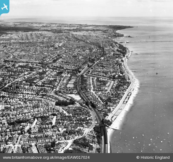
EAW017024 ENGLAND (1948). The town, Southend-on-Sea, from the west, 1948. This image has been produced from a print.
© Copyright OpenStreetMap contributors and licensed by the OpenStreetMap Foundation. 2025. Cartography is licensed as CC BY-SA.
Nearby Images (13)
Details
| Title | [EAW017024] The town, Southend-on-Sea, from the west, 1948. This image has been produced from a print. |
| Reference | EAW017024 |
| Date | 6-July-1948 |
| Link | |
| Place name | SOUTHEND-ON-SEA |
| Parish | |
| District | |
| Country | ENGLAND |
| Easting / Northing | 585485, 185617 |
| Longitude / Latitude | 0.67493114391683, 51.53845217653 |
| National Grid Reference | TQ855856 |
Pins
Be the first to add a comment to this image!


![[EAW017024] The town, Southend-on-Sea, from the west, 1948. This image has been produced from a print.](http://britainfromabove.org.uk/sites/all/libraries/aerofilms-images/public/100x100/EAW/017/EAW017024.jpg)
![[EPW036997] The Ridgeway and environs, Chalkwell, 1931](http://britainfromabove.org.uk/sites/all/libraries/aerofilms-images/public/100x100/EPW/036/EPW036997.jpg)
![[EPW054669] The Chalkwell Esplanade and environs, Chalkwell, 1937](http://britainfromabove.org.uk/sites/all/libraries/aerofilms-images/public/100x100/EPW/054/EPW054669.jpg)
![[EPW036706] Housing surrounding Chalkwell Esplanade, Ridgeway Gardens and the seafront, Southend-on-Sea, 1931](http://britainfromabove.org.uk/sites/all/libraries/aerofilms-images/public/100x100/EPW/036/EPW036706.jpg)
![[EAW053102] Chalkwell Station, The Ridgeway and environs, Southend-on-Sea, 1954](http://britainfromabove.org.uk/sites/all/libraries/aerofilms-images/public/100x100/EAW/053/EAW053102.jpg)
![[EPW039867] Undercliff Gardens, Chalkwell Esplanade and the seafront, Southend-on-Sea, 1932](http://britainfromabove.org.uk/sites/all/libraries/aerofilms-images/public/100x100/EPW/039/EPW039867.jpg)
![[EPW040971] The Chalkwell Esplanade, Chalkwell Railway Station and Chalkwell, Southend-on-Sea, 1933](http://britainfromabove.org.uk/sites/all/libraries/aerofilms-images/public/100x100/EPW/040/EPW040971.jpg)
![[EPW032903] Chalkwell Station and The Ridgeway, Chalkwell, 1930](http://britainfromabove.org.uk/sites/all/libraries/aerofilms-images/public/100x100/EPW/032/EPW032903.jpg)
![[EPW036715] Esplanade Gardens, The Ridgeway and Chalkwell Esplanade, Southend-on-Sea, 1931](http://britainfromabove.org.uk/sites/all/libraries/aerofilms-images/public/100x100/EPW/036/EPW036715.jpg)
![[EPW037000] Chalkwell Esplanade and environs, Chalkwell, from the south-west, 1931](http://britainfromabove.org.uk/sites/all/libraries/aerofilms-images/public/100x100/EPW/037/EPW037000.jpg)
![[EPW037005] Chalkwell railway station and environs, Chalkwell, from the south-west, 1931](http://britainfromabove.org.uk/sites/all/libraries/aerofilms-images/public/100x100/EPW/037/EPW037005.jpg)
![[EPW036714] Undercliff Gardens and housing in the Chalkwell area, Southend-on-Sea, 1931](http://britainfromabove.org.uk/sites/all/libraries/aerofilms-images/public/100x100/EPW/036/EPW036714.jpg)
![[EPW037001] Chalkwell Esplanade and environs, Chalkwell, from the south-west, 1931](http://britainfromabove.org.uk/sites/all/libraries/aerofilms-images/public/100x100/EPW/037/EPW037001.jpg)