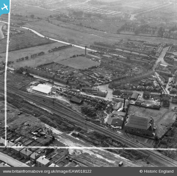
EAW018122 ENGLAND (1948). Godley and Goulding Timber Yard and Saw Mill and environs, Worksop, 1948. This image has been produced from a print marked by Aerofilms Ltd for photo editing.
© Copyright OpenStreetMap contributors and licensed by the OpenStreetMap Foundation. 2024. Cartography is licensed as CC BY-SA.
Nearby Images (18)
Details
| Title | [EAW018122] Godley and Goulding Timber Yard and Saw Mill and environs, Worksop, 1948. This image has been produced from a print marked by Aerofilms Ltd for photo editing. |
| Reference | EAW018122 |
| Date | 11-August-1948 |
| Link | |
| Place name | WORKSOP |
| Parish | |
| District | |
| Country | ENGLAND |
| Easting / Northing | 459088, 379452 |
| Longitude / Latitude | -1.1131118159998, 53.308436849837 |
| National Grid Reference | SK591795 |
Pins
 Jeff Tunningley |
Wednesday 3rd of April 2019 09:59:53 PM | |
 PrioriesHistoricalSociety |
Friday 26th of September 2014 10:42:38 AM | |
 PrioriesHistoricalSociety |
Friday 26th of September 2014 10:38:31 AM | |
 PrioriesHistoricalSociety |
Friday 26th of September 2014 10:37:38 AM |


![[EAW018122] Godley and Goulding Timber Yard and Saw Mill and environs, Worksop, 1948. This image has been produced from a print marked by Aerofilms Ltd for photo editing.](http://britainfromabove.org.uk/sites/all/libraries/aerofilms-images/public/100x100/EAW/018/EAW018122.jpg)
![[EAW018123] Godley and Goulding Timber Yard and Saw Mill and environs, Worksop, 1948. This image has been produced from a print marked by Aerofilms Ltd for photo editing.](http://britainfromabove.org.uk/sites/all/libraries/aerofilms-images/public/100x100/EAW/018/EAW018123.jpg)
![[EPW041456] Godley and Goulding Timber Merchants, Worksop, 1933](http://britainfromabove.org.uk/sites/all/libraries/aerofilms-images/public/100x100/EPW/041/EPW041456.jpg)
![[EPW041462] Godley and Goulding Timber Merchants and surrounding area, Worksop, 1933](http://britainfromabove.org.uk/sites/all/libraries/aerofilms-images/public/100x100/EPW/041/EPW041462.jpg)
![[EPW041458] Godley and Goulding Timber Merchants, Worksop, 1933](http://britainfromabove.org.uk/sites/all/libraries/aerofilms-images/public/100x100/EPW/041/EPW041458.jpg)
![[EPW041455] Godley and Goulding Timber Merchants, Worksop, 1933](http://britainfromabove.org.uk/sites/all/libraries/aerofilms-images/public/100x100/EPW/041/EPW041455.jpg)
![[EAW018124] Godley and Goulding Timber Yard and Saw Mill, Worksop, 1948. This image has been produced from a print marked by Aerofilms Ltd for photo editing.](http://britainfromabove.org.uk/sites/all/libraries/aerofilms-images/public/100x100/EAW/018/EAW018124.jpg)
![[EPW041461] Godley and Goulding Timber Merchants and surrounding area, Worksop, 1933](http://britainfromabove.org.uk/sites/all/libraries/aerofilms-images/public/100x100/EPW/041/EPW041461.jpg)
![[EPW041460] Godley and Goulding Timber Merchants and surrounding area, Worksop, 1933](http://britainfromabove.org.uk/sites/all/libraries/aerofilms-images/public/100x100/EPW/041/EPW041460.jpg)
![[EAW018119] Godley and Goulding Timber Yard and Saw Mill, Worksop, 1948. This image has been produced from a print.](http://britainfromabove.org.uk/sites/all/libraries/aerofilms-images/public/100x100/EAW/018/EAW018119.jpg)
![[EAW018117] Godley and Goulding Timber Yard and Saw Mill, Worksop, 1948. This image has been produced from a print.](http://britainfromabove.org.uk/sites/all/libraries/aerofilms-images/public/100x100/EAW/018/EAW018117.jpg)
![[EAW018120] Godley and Goulding Timber Yard and Saw Mill and environs, Worksop, 1948. This image has been produced from a print marked by Aerofilms Ltd for photo editing.](http://britainfromabove.org.uk/sites/all/libraries/aerofilms-images/public/100x100/EAW/018/EAW018120.jpg)
![[EAW018125] Godley and Goulding Timber Yard and Saw Mill, Worksop, 1948. This image has been produced from a print.](http://britainfromabove.org.uk/sites/all/libraries/aerofilms-images/public/100x100/EAW/018/EAW018125.jpg)
![[EPW041459] Godley and Goulding Timber Merchants and surrounding area, Worksop, 1933](http://britainfromabove.org.uk/sites/all/libraries/aerofilms-images/public/100x100/EPW/041/EPW041459.jpg)
![[EAW018121] Godley and Goulding Timber Yard and Saw Mill, Worksop, 1948. This image has been produced from a print marked by Aerofilms Ltd for photo editing.](http://britainfromabove.org.uk/sites/all/libraries/aerofilms-images/public/100x100/EAW/018/EAW018121.jpg)
![[EAW018118] Godley and Goulding Timber Yard and Saw Mill, Worksop, 1948. This image has been produced from a print marked by Aerofilms Ltd for photo editing.](http://britainfromabove.org.uk/sites/all/libraries/aerofilms-images/public/100x100/EAW/018/EAW018118.jpg)
![[EAW018116] Godley and Goulding Timber Yard and Saw Mill, Worksop, 1948. This image has been produced from a print marked by Aerofilms Ltd for photo editing.](http://britainfromabove.org.uk/sites/all/libraries/aerofilms-images/public/100x100/EAW/018/EAW018116.jpg)
![[EPW041457] Godley and Goulding Timber Merchants and surrounding area, Worksop, 1933](http://britainfromabove.org.uk/sites/all/libraries/aerofilms-images/public/100x100/EPW/041/EPW041457.jpg)