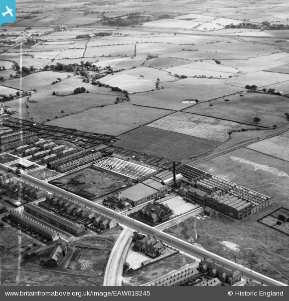
EAW018245 ENGLAND (1948). Victoria Mill on Chorley New Road and environs, Horwich, 1948. This image was marked by Aerofilms Ltd for photo editing.
© Copyright OpenStreetMap contributors and licensed by the OpenStreetMap Foundation. 2024. Cartography is licensed as CC BY-SA.
Nearby Images (9)
Details
| Title | [EAW018245] Victoria Mill on Chorley New Road and environs, Horwich, 1948. This image was marked by Aerofilms Ltd for photo editing. |
| Reference | EAW018245 |
| Date | 18-August-1948 |
| Link | |
| Place name | HORWICH |
| Parish | HORWICH |
| District | |
| Country | ENGLAND |
| Easting / Northing | 364644, 410293 |
| Longitude / Latitude | -2.5341693745729, 53.587787520551 |
| National Grid Reference | SD646103 |
Pins
 William Nuttall |
Monday 13th of April 2020 09:41:52 PM | |
 mannidaze |
Sunday 27th of March 2016 12:50:54 PM | |
 thomasknight |
Sunday 12th of April 2015 12:18:36 PM | |
 thomasknight |
Sunday 12th of April 2015 12:16:09 PM | |
 thomasknight |
Sunday 12th of April 2015 12:15:20 PM |


![[EAW018245] Victoria Mill on Chorley New Road and environs, Horwich, 1948. This image was marked by Aerofilms Ltd for photo editing.](http://britainfromabove.org.uk/sites/all/libraries/aerofilms-images/public/100x100/EAW/018/EAW018245.jpg)
![[EAW018241] Mills and houses along Chorley New Road, Horwich, from the south, 1948. This image was marked by Aerofilms Ltd for photo editing.](http://britainfromabove.org.uk/sites/all/libraries/aerofilms-images/public/100x100/EAW/018/EAW018241.jpg)
![[EAW018242] Mills and houses along Chorley New Road, Horwich, from the south, 1948](http://britainfromabove.org.uk/sites/all/libraries/aerofilms-images/public/100x100/EAW/018/EAW018242.jpg)
![[EAW018246] Mills and houses along Chorley New Road and environs, Horwich, from the north-east, 1948](http://britainfromabove.org.uk/sites/all/libraries/aerofilms-images/public/100x100/EAW/018/EAW018246.jpg)
![[EAW018248] Victoria Mill on Chorley New Road, Horwich, 1948. This image was marked by Aerofilms Ltd for photo editing.](http://britainfromabove.org.uk/sites/all/libraries/aerofilms-images/public/100x100/EAW/018/EAW018248.jpg)
![[EAW018249] Mills and houses along Chorley New Road, Horwich, from the north-east, 1948](http://britainfromabove.org.uk/sites/all/libraries/aerofilms-images/public/100x100/EAW/018/EAW018249.jpg)
![[EAW018243] Mills and houses along Chorley New Road, Horwich, from the south-west, 1948. This image was marked by Aerofilms Ltd for photo editing.](http://britainfromabove.org.uk/sites/all/libraries/aerofilms-images/public/100x100/EAW/018/EAW018243.jpg)
![[EAW018247] Mills and houses along Chorley New Road and environs, Horwich, from the north-east, 1948](http://britainfromabove.org.uk/sites/all/libraries/aerofilms-images/public/100x100/EAW/018/EAW018247.jpg)
![[EAW018244] Mills and houses along Chorley New Road, Horwich, from the south-west, 1948](http://britainfromabove.org.uk/sites/all/libraries/aerofilms-images/public/100x100/EAW/018/EAW018244.jpg)