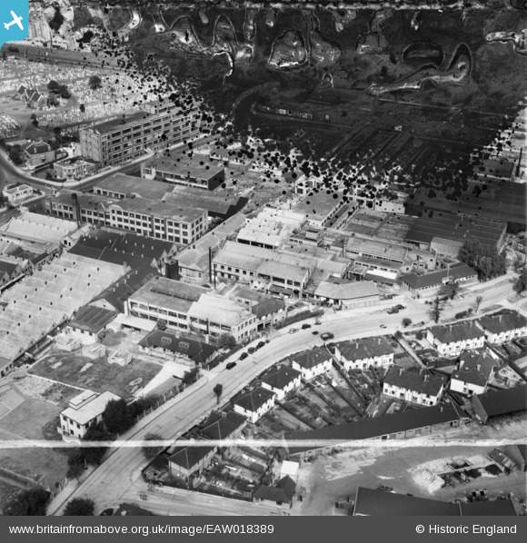
EAW018389 ENGLAND (1948). Wales Farm Road, the Telegraph Condenser Co Ltd Works and environs, North Acton, 1948. This image has been produced from a damaged negative.
© Copyright OpenStreetMap contributors and licensed by the OpenStreetMap Foundation. 2025. Cartography is licensed as CC BY-SA.
Nearby Images (34)
Details
| Title | [EAW018389] Wales Farm Road, the Telegraph Condenser Co Ltd Works and environs, North Acton, 1948. This image has been produced from a damaged negative. |
| Reference | EAW018389 |
| Date | 27-August-1948 |
| Link | |
| Place name | NORTH ACTON |
| Parish | |
| District | |
| Country | ENGLAND |
| Easting / Northing | 520746, 181713 |
| Longitude / Latitude | -0.25943889076328, 51.520930355243 |
| National Grid Reference | TQ207817 |
Pins
 Matt Aldred edob.mattaldred.com |
Thursday 7th of March 2024 03:10:32 PM | |
 Matt Aldred edob.mattaldred.com |
Thursday 7th of March 2024 03:08:13 PM | |
 Class31 |
Monday 22nd of December 2014 12:47:48 PM |


![[EAW018389] Wales Farm Road, the Telegraph Condenser Co Ltd Works and environs, North Acton, 1948. This image has been produced from a damaged negative.](http://britainfromabove.org.uk/sites/all/libraries/aerofilms-images/public/100x100/EAW/018/EAW018389.jpg)
![[EPW035222] Telegraph Condenser Works and adjacent businesses on Wales Farm Road, North Acton, 1931](http://britainfromabove.org.uk/sites/all/libraries/aerofilms-images/public/100x100/EPW/035/EPW035222.jpg)
![[EPW035221] Telegraph Condenser Works and adjacent businesses on Wales Farm Road, North Acton, 1931](http://britainfromabove.org.uk/sites/all/libraries/aerofilms-images/public/100x100/EPW/035/EPW035221.jpg)
![[EPW035224] Telegraph Condenser Works and adjacent businesses on Wales Farm Road, North Acton, 1931](http://britainfromabove.org.uk/sites/all/libraries/aerofilms-images/public/100x100/EPW/035/EPW035224.jpg)
![[EAW018395] Industrial properties between Victoria Road and Wales Farm Road, North Acton, 1948. This image was marked by Aerofilms Ltd for photo editing.](http://britainfromabove.org.uk/sites/all/libraries/aerofilms-images/public/100x100/EAW/018/EAW018395.jpg)
![[EPW035225] Telegraph Condenser Works and adjacent businesses on Wales Farm Road, North Acton, 1931](http://britainfromabove.org.uk/sites/all/libraries/aerofilms-images/public/100x100/EPW/035/EPW035225.jpg)
![[EPW035227] Telegraph Condenser Works and adjacent businesses on Wales Farm Road, North Acton, 1931](http://britainfromabove.org.uk/sites/all/libraries/aerofilms-images/public/100x100/EPW/035/EPW035227.jpg)
![[EAW018390] Industrial properties between Acton Cemetery and Wales Farm Road, North Acton, from the south-east, 1948. This image has been produced from a damaged negative.](http://britainfromabove.org.uk/sites/all/libraries/aerofilms-images/public/100x100/EAW/018/EAW018390.jpg)
![[EPW035226] Telegraph Condenser Works and adjacent businesses on Wales Farm Road, North Acton, 1931](http://britainfromabove.org.uk/sites/all/libraries/aerofilms-images/public/100x100/EPW/035/EPW035226.jpg)
![[EAW019883B] The Telegraph Condenser Co Ltd Works and other factories, North Acton, 1948. This image was modified by the Aerofilms Ltd Artists' Department and has been produced from a copy-negative.](http://britainfromabove.org.uk/sites/all/libraries/aerofilms-images/public/100x100/EAW/019/EAW019883B.jpg)
![[EAW019883A] The Telegraph Condenser Co Ltd Works and other factories, North Acton, 1948. This image was modified by the Aerofilms Ltd Artists' Department and has been produced from a copy-negative.](http://britainfromabove.org.uk/sites/all/libraries/aerofilms-images/public/100x100/EAW/019/EAW019883A.jpg)
![[EPW035220] Telegraph Condenser Works and adjacent businesses on Wales Farm Road, North Acton, 1931](http://britainfromabove.org.uk/sites/all/libraries/aerofilms-images/public/100x100/EPW/035/EPW035220.jpg)
![[EPW035219] Telegraph Condenser Works and adjacent businesses on Wales Farm Road, North Acton, 1931](http://britainfromabove.org.uk/sites/all/libraries/aerofilms-images/public/100x100/EPW/035/EPW035219.jpg)
![[EPW035223] Telegraph Condenser Works and adjacent businesses on Wales Farm Road, North Acton, 1931](http://britainfromabove.org.uk/sites/all/libraries/aerofilms-images/public/100x100/EPW/035/EPW035223.jpg)
![[EAW019882] The Telegraph Condenser Co Ltd Works and environs, North Acton, from the east, 1948. This image has been produced from a print marked by Aerofilms Ltd for photo editing.](http://britainfromabove.org.uk/sites/all/libraries/aerofilms-images/public/100x100/EAW/019/EAW019882.jpg)
![[EAW018391] Industrial properties between Victoria Road and Wales Farm Road, North Acton, 1948. This image was marked by Aerofilms Ltd for photo editing.](http://britainfromabove.org.uk/sites/all/libraries/aerofilms-images/public/100x100/EAW/018/EAW018391.jpg)
![[EAW018394] Industrial properties between Victoria Road and Wales Farm Road, North Acton, 1948. This image was marked by Aerofilms Ltd for photo editing.](http://britainfromabove.org.uk/sites/all/libraries/aerofilms-images/public/100x100/EAW/018/EAW018394.jpg)
![[EAW018396] Industrial properties between Victoria Road and Wales Farm Road, North Acton, 1948. This image was marked by Aerofilms Ltd for photo editing.](http://britainfromabove.org.uk/sites/all/libraries/aerofilms-images/public/100x100/EAW/018/EAW018396.jpg)
![[EAW018392] Industrial properties between Acton Cemetery and Wales Farm Road, North Acton, 1948. This image was marked by Aerofilms Ltd for photo editing.](http://britainfromabove.org.uk/sites/all/libraries/aerofilms-images/public/100x100/EAW/018/EAW018392.jpg)
![[EAW018393] Industrial properties between Acton Cemetery and Wales Farm Road, North Acton, 1948. This image was marked by Aerofilms Ltd for photo editing.](http://britainfromabove.org.uk/sites/all/libraries/aerofilms-images/public/100x100/EAW/018/EAW018393.jpg)
![[EAW019885] The Telegraph Condenser Co Ltd Works and other factories, North Acton, from the south-west, 1948. This image has been produced from a print.](http://britainfromabove.org.uk/sites/all/libraries/aerofilms-images/public/100x100/EAW/019/EAW019885.jpg)
![[EAW019886] The Telegraph Condenser Co Ltd Works and other factories, North Acton, 1948](http://britainfromabove.org.uk/sites/all/libraries/aerofilms-images/public/100x100/EAW/019/EAW019886.jpg)
![[EAW018388] The Landis and Gyr Ltd Elgee Electrical Engineering Works, Acton Cemetery and environs, North Acton, 1948. This image has been produced from a damaged negative.](http://britainfromabove.org.uk/sites/all/libraries/aerofilms-images/public/100x100/EAW/018/EAW018388.jpg)
![[EAW019884] The Telegraph Condenser Co Ltd Works, Acton Cemetery and environs, North Acton, 1948. This image has been produced from a print marked by Aerofilms Ltd for photo editing.](http://britainfromabove.org.uk/sites/all/libraries/aerofilms-images/public/100x100/EAW/019/EAW019884.jpg)
![[EPW058340] The Ducon Condenser Works and the surrounding residential and industrial area, North Acton, 1938. This image has been produced from a damaged negative.](http://britainfromabove.org.uk/sites/all/libraries/aerofilms-images/public/100x100/EPW/058/EPW058340.jpg)
![[EPW048128] The Landis and Gyr Ltd Elgee Electrical Engineering Works and Victoria Road, North Acton, 1935](http://britainfromabove.org.uk/sites/all/libraries/aerofilms-images/public/100x100/EPW/048/EPW048128.jpg)
![[EPW048130] The Landis and Gyr Ltd Elgee Electrical Engineering Works and Victoria Road, North Acton, 1935](http://britainfromabove.org.uk/sites/all/libraries/aerofilms-images/public/100x100/EPW/048/EPW048130.jpg)
![[EPW048127] The Landis and Gyr Ltd Elgee Electrical Engineering Works, North Acton, 1935](http://britainfromabove.org.uk/sites/all/libraries/aerofilms-images/public/100x100/EPW/048/EPW048127.jpg)
![[EPW048131] The Landis and Gyr Ltd Elgee Electrical Engineering Works, Victoria Road, Acton Cemetery and environs, North Acton, 1935](http://britainfromabove.org.uk/sites/all/libraries/aerofilms-images/public/100x100/EPW/048/EPW048131.jpg)
![[EAW019883] The Telegraph Condenser Co Ltd Works, Acton Cemetery and environs, North Acton, from the east, 1948. This image has been produced from a print marked by Aerofilms Ltd for photo editing.](http://britainfromabove.org.uk/sites/all/libraries/aerofilms-images/public/100x100/EAW/019/EAW019883.jpg)
![[EPW048129] The Landis and Gyr Ltd Elgee Electrical Engineering Works and Acton Cemetery, North Acton, 1935](http://britainfromabove.org.uk/sites/all/libraries/aerofilms-images/public/100x100/EPW/048/EPW048129.jpg)
![[EAW019881] The Telegraph Condenser Co Ltd Works and environs, North Acton, 1948. This image has been produced from a print marked by Aerofilms Ltd for photo editing.](http://britainfromabove.org.uk/sites/all/libraries/aerofilms-images/public/100x100/EAW/019/EAW019881.jpg)
![[EPW058338] The Ducon Condenser Works and the surrounding residential and industrial area, North Acton, 1938](http://britainfromabove.org.uk/sites/all/libraries/aerofilms-images/public/100x100/EPW/058/EPW058338.jpg)
![[EPW062804] The Dubilier Condenser Co Ducon Works, North Acton, 1939](http://britainfromabove.org.uk/sites/all/libraries/aerofilms-images/public/100x100/EPW/062/EPW062804.jpg)