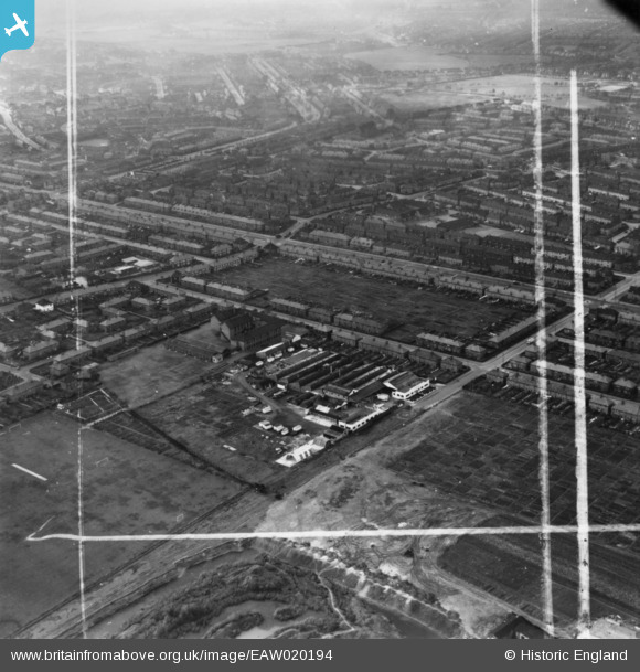
EAW020194 ENGLAND (1948). The W. J. Barton Ltd Bakery on Kemp Road and environs, Dagenham, 1948. This image has been produced from a print marked by Aerofilms Ltd for photo editing.
© Copyright OpenStreetMap contributors and licensed by the OpenStreetMap Foundation. 2025. Cartography is licensed as CC BY-SA.
Nearby Images (13)
Details
| Title | [EAW020194] The W. J. Barton Ltd Bakery on Kemp Road and environs, Dagenham, 1948. This image has been produced from a print marked by Aerofilms Ltd for photo editing. |
| Reference | EAW020194 |
| Date | 28-October-1948 |
| Link | |
| Place name | DAGENHAM |
| Parish | |
| District | |
| Country | ENGLAND |
| Easting / Northing | 547861, 187093 |
| Longitude / Latitude | 0.13342153782241, 51.562828395949 |
| National Grid Reference | TQ479871 |
Pins
 GRP47 |
Tuesday 15th of December 2015 03:01:56 PM | |
 GRP47 |
Tuesday 15th of December 2015 02:59:33 PM | |
 GRP47 |
Tuesday 15th of December 2015 02:57:12 PM | |
 GRP47 |
Tuesday 15th of December 2015 02:55:58 PM | |
 GRP47 |
Tuesday 15th of December 2015 02:55:13 PM |


![[EAW020194] The W. J. Barton Ltd Bakery on Kemp Road and environs, Dagenham, 1948. This image has been produced from a print marked by Aerofilms Ltd for photo editing.](http://britainfromabove.org.uk/sites/all/libraries/aerofilms-images/public/100x100/EAW/020/EAW020194.jpg)
![[EAW020187] The W. J. Barton Ltd Bakery on Kemp Road and environs, Dagenham, 1948. This image has been produced from a print marked by Aerofilms Ltd for photo editing.](http://britainfromabove.org.uk/sites/all/libraries/aerofilms-images/public/100x100/EAW/020/EAW020187.jpg)
![[EAW020192] The W. J. Barton Ltd Bakery on Kemp Road and environs, Dagenham, 1948. This image has been produced from a print marked by Aerofilms Ltd for photo editing.](http://britainfromabove.org.uk/sites/all/libraries/aerofilms-images/public/100x100/EAW/020/EAW020192.jpg)
![[EAW020185] The W. J. Barton Ltd Bakery on Kemp Road and environs, Dagenham, 1948. This image has been produced from a print marked by Aerofilms Ltd for photo editing.](http://britainfromabove.org.uk/sites/all/libraries/aerofilms-images/public/100x100/EAW/020/EAW020185.jpg)
![[EAW020193] The W. J. Barton Ltd Bakery on Kemp Road and environs, Dagenham, 1948. This image has been produced from a print marked by Aerofilms Ltd for photo editing.](http://britainfromabove.org.uk/sites/all/libraries/aerofilms-images/public/100x100/EAW/020/EAW020193.jpg)
![[EAW020188] The W. J. Barton Ltd Bakery on Kemp Road and environs, Dagenham, 1948. This image has been produced from a print marked by Aerofilms Ltd for photo editing.](http://britainfromabove.org.uk/sites/all/libraries/aerofilms-images/public/100x100/EAW/020/EAW020188.jpg)
![[EAW020189] The W. J. Barton Ltd Bakery on Kemp Road and environs, Dagenham, 1948. This image has been produced from a print marked by Aerofilms Ltd for photo editing.](http://britainfromabove.org.uk/sites/all/libraries/aerofilms-images/public/100x100/EAW/020/EAW020189.jpg)
![[EAW020191] The W. J. Barton Ltd Bakery on Kemp Road and environs, Dagenham, 1948. This image has been produced from a print marked by Aerofilms Ltd for photo editing.](http://britainfromabove.org.uk/sites/all/libraries/aerofilms-images/public/100x100/EAW/020/EAW020191.jpg)
![[EAW020196] The W. J. Barton Ltd Bakery on Kemp Road and environs, Dagenham, 1948. This image has been produced from a print marked by Aerofilms Ltd for photo editing.](http://britainfromabove.org.uk/sites/all/libraries/aerofilms-images/public/100x100/EAW/020/EAW020196.jpg)
![[EAW020195] The W. J. Barton Ltd Bakery on Kemp Road and environs, Dagenham, 1948. This image has been produced from a print marked by Aerofilms Ltd for photo editing.](http://britainfromabove.org.uk/sites/all/libraries/aerofilms-images/public/100x100/EAW/020/EAW020195.jpg)
![[EPW006555] A new housing estate under construction, Chadwell Heath, from the north-east, 1921](http://britainfromabove.org.uk/sites/all/libraries/aerofilms-images/public/100x100/EPW/006/EPW006555.jpg)
![[EAW020190] The W. J. Barton Ltd Bakery on Kemp Road and environs, Dagenham, 1948. This image has been produced from a print marked by Aerofilms Ltd for photo editing.](http://britainfromabove.org.uk/sites/all/libraries/aerofilms-images/public/100x100/EAW/020/EAW020190.jpg)
![[EAW020186] The W. J. Barton Ltd Bakery on Kemp Road and environs, Dagenham, from the north, 1948. This image has been produced from a print marked by Aerofilms Ltd for photo editing.](http://britainfromabove.org.uk/sites/all/libraries/aerofilms-images/public/100x100/EAW/020/EAW020186.jpg)