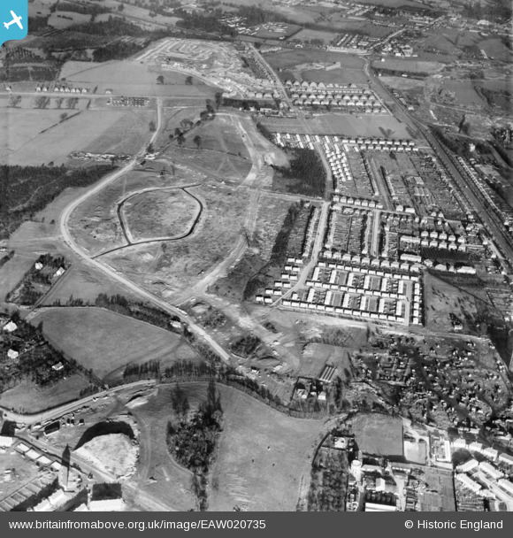
EAW020735 ENGLAND (1948). New housing development around Saxville Road and the early stages of contstruction at Ravenscourt Road, St Paul's Cray, 1948
© Copyright OpenStreetMap contributors and licensed by the OpenStreetMap Foundation. 2025. Cartography is licensed as CC BY-SA.
Details
| Title | [EAW020735] New housing development around Saxville Road and the early stages of contstruction at Ravenscourt Road, St Paul's Cray, 1948 |
| Reference | EAW020735 |
| Date | 24-December-1948 |
| Link | |
| Place name | ST PAUL'S CRAY |
| Parish | |
| District | |
| Country | ENGLAND |
| Easting / Northing | 546689, 168983 |
| Longitude / Latitude | 0.10900036537788, 51.400390500974 |
| National Grid Reference | TQ467690 |
Pins
 garyb |
Thursday 6th of April 2017 08:02:53 PM | |
 garyb |
Thursday 6th of April 2017 07:50:13 PM | |
 garyb |
Thursday 6th of April 2017 07:48:30 PM | |
 Starbug |
Tuesday 24th of June 2014 06:59:41 PM | |
 garyb |
Wednesday 4th of June 2014 12:33:39 AM | |
 garyb |
Friday 30th of May 2014 04:27:57 PM | |
 garyb |
Friday 30th of May 2014 03:59:33 PM | |
 garyb |
Friday 30th of May 2014 12:17:49 PM | |
 garyb |
Friday 30th of May 2014 12:06:11 PM | |
 garyb |
Friday 30th of May 2014 11:52:54 AM | |
 garyb |
Friday 30th of May 2014 11:33:06 AM | |
 garyb |
Friday 30th of May 2014 01:23:03 AM | |
 garyb |
Friday 30th of May 2014 01:03:00 AM | |
 garyb |
Friday 30th of May 2014 01:01:04 AM | |
 Gone2Kent |
Sunday 2nd of March 2014 08:10:18 PM | |
If I remember correctly, in the early days of the estate this shop was 'Liptons' and opposite was a competitor shop named 'Victor Value'. |
 garyb |
Friday 30th of May 2014 12:27:40 PM |
 Gone2Kent |
Wednesday 25th of December 2013 04:50:26 PM | |
 Gone2Kent |
Wednesday 25th of December 2013 04:48:48 PM | |
 Gone2Kent |
Wednesday 25th of December 2013 04:44:13 PM | |
 Gone2Kent |
Wednesday 25th of December 2013 04:43:24 PM | |
 Gone2Kent |
Wednesday 25th of December 2013 04:38:48 PM | |
 Mike Floate |
Monday 23rd of December 2013 07:34:08 PM | |
 Mike Floate |
Monday 23rd of December 2013 07:31:09 PM |


![[EAW020735] New housing development around Saxville Road and the early stages of contstruction at Ravenscourt Road, St Paul's Cray, 1948](http://britainfromabove.org.uk/sites/all/libraries/aerofilms-images/public/100x100/EAW/020/EAW020735.jpg)
![[EAW020723] New housing development off Broomwood Road and the early stages of construction at Ravenscourt Road, St Paul's Cray, 1948. This image was marked by Aerofilms Ltd for photo editing.](http://britainfromabove.org.uk/sites/all/libraries/aerofilms-images/public/100x100/EAW/020/EAW020723.jpg)