
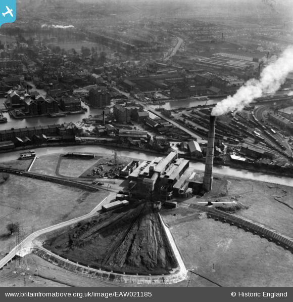
EAW021185 ENGLAND (1949). Castle Meads Power Station and the docks, Gloucester, 1949. This image has been produced from a print.
© Copyright OpenStreetMap contributors and licensed by the OpenStreetMap Foundation. 2025. Cartography is licensed as CC BY-SA.
Nearby Images (26)
EAW021185

EAW012210

EAW021181

EAW021182

EAW021184

EAW018728

EAW021183

EAW012209

EPW037749

EPW037837

EAW012202

EAW012200

EAW012204

EPW037834

EAW012207

EPW037750

EPW037751

EPW024161

EAW021187

EAW012197

EAW012211

EAW021189

EPW024154

EPW038346

EPW038343

EPW038344

Details
| Title | [EAW021185] Castle Meads Power Station and the docks, Gloucester, 1949. This image has been produced from a print. |
| Reference | EAW021185 |
| Date | 2-March-1949 |
| Link | |
| Place name | GLOUCESTER |
| Parish | |
| District | |
| Country | ENGLAND |
| Easting / Northing | 382509, 218281 |
| Longitude / Latitude | -2.2540296462235, 51.862395727677 |
| National Grid Reference | SO825183 |
Pins
 |
 Class31 |
Wednesday 3rd of June 2015 08:31:15 PM |
 Toby Clempson |
Wednesday 3rd of September 2014 12:57:17 PM | |
Toby Clempson |
Wednesday 3rd of September 2014 12:56:39 PM | |
Toby Clempson |
Wednesday 3rd of September 2014 12:54:29 PM | |
Toby Clempson |
Wednesday 3rd of September 2014 12:53:38 PM |