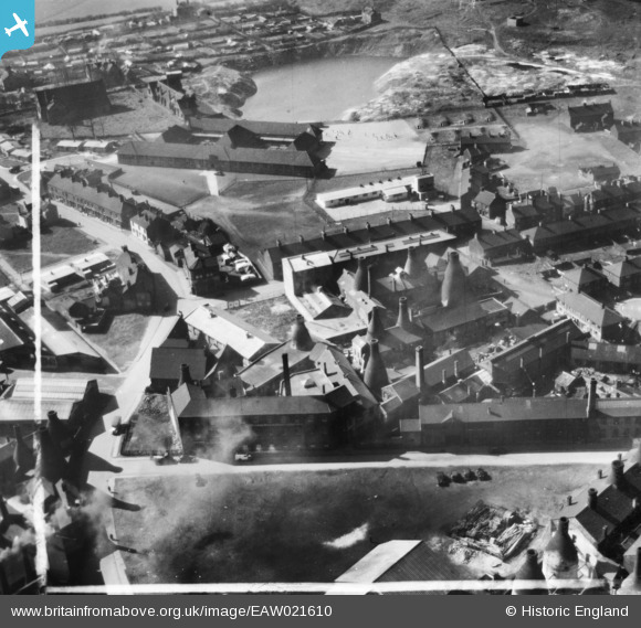
EAW021610 ENGLAND (1949). The Edensor and Cobden China Works and environs, Longton, 1949. This image has been produced from a print marked by Aerofilms Ltd for photo editing.
© Copyright OpenStreetMap contributors and licensed by the OpenStreetMap Foundation. 2025. Cartography is licensed as CC BY-SA.
Nearby Images (31)
Details
| Title | [EAW021610] The Edensor and Cobden China Works and environs, Longton, 1949. This image has been produced from a print marked by Aerofilms Ltd for photo editing. |
| Reference | EAW021610 |
| Date | 25-March-1949 |
| Link | |
| Place name | LONGTON |
| Parish | |
| District | |
| Country | ENGLAND |
| Easting / Northing | 390758, 343188 |
| Longitude / Latitude | -2.1376810623618, 52.985640748949 |
| National Grid Reference | SJ908432 |
Pins
Be the first to add a comment to this image!


![[EAW021610] The Edensor and Cobden China Works and environs, Longton, 1949. This image has been produced from a print marked by Aerofilms Ltd for photo editing.](http://britainfromabove.org.uk/sites/all/libraries/aerofilms-images/public/100x100/EAW/021/EAW021610.jpg)
![[EAW021611] The Edensor and Cobden China Works and environs, Longton, 1949. This image has been produced from a print marked by Aerofilms Ltd for photo editing.](http://britainfromabove.org.uk/sites/all/libraries/aerofilms-images/public/100x100/EAW/021/EAW021611.jpg)
![[EAW021613] The Edensor and Cobden China Works and environs, Longton, 1949. This image has been produced from a print marked by Aerofilms Ltd for photo editing.](http://britainfromabove.org.uk/sites/all/libraries/aerofilms-images/public/100x100/EAW/021/EAW021613.jpg)
![[EAW021612] The Edensor and Cobden China Works and environs, Longton, 1949. This image has been produced from a print marked by Aerofilms Ltd for photo editing.](http://britainfromabove.org.uk/sites/all/libraries/aerofilms-images/public/100x100/EAW/021/EAW021612.jpg)
![[EAW021614] The Edensor and Cobden China Works and environs, Longton, 1949. This image has been produced from a print marked by Aerofilms Ltd for photo editing.](http://britainfromabove.org.uk/sites/all/libraries/aerofilms-images/public/100x100/EAW/021/EAW021614.jpg)
![[EAW021616] The Edensor and Cobden China Works and environs, Longton, 1949. This image has been produced from a print marked by Aerofilms Ltd for photo editing.](http://britainfromabove.org.uk/sites/all/libraries/aerofilms-images/public/100x100/EAW/021/EAW021616.jpg)
![[EAW021609] The Edensor and Cobden China Works and environs, Longton, 1949. This image has been produced from a print marked by Aerofilms Ltd for photo editing.](http://britainfromabove.org.uk/sites/all/libraries/aerofilms-images/public/100x100/EAW/021/EAW021609.jpg)
![[EAW030707] Cooke Street and the John Beswick Ltd Earthenware Factory off Gold Street, Longton, 1950](http://britainfromabove.org.uk/sites/all/libraries/aerofilms-images/public/100x100/EAW/030/EAW030707.jpg)
![[EAW030705] Cooke Street and the John Beswick Ltd Earthenware Factory off Gold Street, Longton, 1950. This image was marked by Aerofilms Ltd for photo editing.](http://britainfromabove.org.uk/sites/all/libraries/aerofilms-images/public/100x100/EAW/030/EAW030705.jpg)
![[EAW030701] Cooke Street and the John Beswick Ltd Earthenware Factory off Gold Street, Longton, 1950. This image was marked by Aerofilms Ltd for photo editing.](http://britainfromabove.org.uk/sites/all/libraries/aerofilms-images/public/100x100/EAW/030/EAW030701.jpg)
![[EAW030704] John Beswick Ltd Earthenware Factory off Gold Street and the Bus Station, Longton, 1950](http://britainfromabove.org.uk/sites/all/libraries/aerofilms-images/public/100x100/EAW/030/EAW030704.jpg)
![[EAW030699] John Beswick Ltd Earthenware Factory off Gold Street, Longton, 1950. This image was marked by Aerofilms Ltd for photo editing.](http://britainfromabove.org.uk/sites/all/libraries/aerofilms-images/public/100x100/EAW/030/EAW030699.jpg)
![[EAW030703] John Beswick Ltd Earthenware Factory off Gold Street, Longton, 1950](http://britainfromabove.org.uk/sites/all/libraries/aerofilms-images/public/100x100/EAW/030/EAW030703.jpg)
![[EAW030708] John Beswick Ltd Earthenware Factory off Gold Street, Longton, 1950. This image was marked by Aerofilms Ltd for photo editing.](http://britainfromabove.org.uk/sites/all/libraries/aerofilms-images/public/100x100/EAW/030/EAW030708.jpg)
![[EPW020078] The town centre, Longton, from the south-west, 1927](http://britainfromabove.org.uk/sites/all/libraries/aerofilms-images/public/100x100/EPW/020/EPW020078.jpg)
![[EAW030697] John Beswick Ltd Earthenware Factory off Gold Street and the Bus Station, Longton, 1950](http://britainfromabove.org.uk/sites/all/libraries/aerofilms-images/public/100x100/EAW/030/EAW030697.jpg)
![[EAW030706] John Beswick Ltd Earthenware Factory off Gold Street and St Gregory's Roman Catholic Church, Longton, 1950](http://britainfromabove.org.uk/sites/all/libraries/aerofilms-images/public/100x100/EAW/030/EAW030706.jpg)
![[EAW030698] John Beswick Ltd Earthenware Factory off Gold Street and St Gregory's Roman Catholic Church, Longton, 1950. This image was marked by Aerofilms Ltd for photo editing.](http://britainfromabove.org.uk/sites/all/libraries/aerofilms-images/public/100x100/EAW/030/EAW030698.jpg)
![[EAW030700] John Beswick Ltd Earthenware Factory off Gold Street and St Gregory's Roman Catholic Church, Longton, 1950](http://britainfromabove.org.uk/sites/all/libraries/aerofilms-images/public/100x100/EAW/030/EAW030700.jpg)
![[EAW018069] The Cartwright and Edwards Ltd Borough Pottery extension under construction and environs, Longton, 1948. This image has been produced from a print.](http://britainfromabove.org.uk/sites/all/libraries/aerofilms-images/public/100x100/EAW/018/EAW018069.jpg)
![[EAW030702] John Beswick Ltd Earthenware Factory off Gold Street, Longton, 1950](http://britainfromabove.org.uk/sites/all/libraries/aerofilms-images/public/100x100/EAW/030/EAW030702.jpg)
![[EAW018070] The Cartwright and Edwards Ltd Borough Pottery extension under construction, Stafford Street and environs, Longton, 1948. This image has been produced from a print marked by Aerofilms Ltd for photo editing.](http://britainfromabove.org.uk/sites/all/libraries/aerofilms-images/public/100x100/EAW/018/EAW018070.jpg)
![[EAW018072] The Cartwright and Edwards Ltd Borough Pottery extension under construction and environs, Longton, 1948. This image has been produced from a print marked by Aerofilms Ltd for photo editing.](http://britainfromabove.org.uk/sites/all/libraries/aerofilms-images/public/100x100/EAW/018/EAW018072.jpg)
![[EAW018067] The Cartwright and Edwards Ltd Borough Pottery extension under construction and environs, Longton, 1948. This image has been produced from a print.](http://britainfromabove.org.uk/sites/all/libraries/aerofilms-images/public/100x100/EAW/018/EAW018067.jpg)
![[EAW013142] The potteries and the town, Longton, from the south-west, 1948](http://britainfromabove.org.uk/sites/all/libraries/aerofilms-images/public/100x100/EAW/013/EAW013142.jpg)
![[EAW013144] The potteries and the town, Longton, from the north-west, 1948](http://britainfromabove.org.uk/sites/all/libraries/aerofilms-images/public/100x100/EAW/013/EAW013144.jpg)
![[EAW018066] The Cartwright and Edwards Ltd Borough Pottery extension under construction, Daisy Bank Pottery and environs, Longton, 1948. This image has been produced from a print.](http://britainfromabove.org.uk/sites/all/libraries/aerofilms-images/public/100x100/EAW/018/EAW018066.jpg)
![[EAW018073] The Cartwright and Edwards Ltd Borough Pottery extension under construction, Stafford Street and environs, Longton, 1948. This image has been produced from a print.](http://britainfromabove.org.uk/sites/all/libraries/aerofilms-images/public/100x100/EAW/018/EAW018073.jpg)
![[EAW018071] The Cartwright and Edwards Ltd Borough Pottery extension under construction, Daisy Bank Pottery and environs, Longton, 1948. This image has been produced from a print marked by Aerofilms Ltd for photo editing.](http://britainfromabove.org.uk/sites/all/libraries/aerofilms-images/public/100x100/EAW/018/EAW018071.jpg)
![[EAW018065] The Cartwright and Edwards Ltd Borough Pottery extension under construction and environs, Longton, 1948. This image has been produced from a print.](http://britainfromabove.org.uk/sites/all/libraries/aerofilms-images/public/100x100/EAW/018/EAW018065.jpg)
![[EAW018068] The Cartwright and Edwards Ltd Borough Pottery extension under construction and environs, Longton, 1948. This image has been produced from a print marked by Aerofilms Ltd for photo editing.](http://britainfromabove.org.uk/sites/all/libraries/aerofilms-images/public/100x100/EAW/018/EAW018068.jpg)