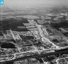
EAW022134 ENGLAND (1949). The South Oxhey Housing Estate under construction around Hayling Road, South Oxhey, from the east, 1949
© Copyright OpenStreetMap contributors and licensed by the OpenStreetMap Foundation. 2025. Cartography is licensed as CC BY-SA.
Details
| Title | [EAW022134] The South Oxhey Housing Estate under construction around Hayling Road, South Oxhey, from the east, 1949 |
| Reference | EAW022134 |
| Date | 14-April-1949 |
| Link | |
| Place name | SOUTH OXHEY |
| Parish | WATFORD RURAL |
| District | |
| Country | ENGLAND |
| Easting / Northing | 511563, 193359 |
| Longitude / Latitude | -0.38805432071936, 51.627503289836 |
| National Grid Reference | TQ116934 |
Pins
 John Swain |
Sunday 22nd of December 2013 04:53:59 PM | |
 John Swain |
Sunday 22nd of December 2013 04:51:11 PM | |
 John Swain |
Friday 20th of December 2013 11:33:34 AM | |
 John Swain |
Friday 20th of December 2013 11:20:05 AM | |
 John Swain |
Friday 20th of December 2013 11:14:59 AM | |
 John Swain |
Friday 20th of December 2013 11:14:14 AM | |
 John Swain |
Friday 20th of December 2013 11:13:09 AM | |
 John Swain |
Friday 20th of December 2013 11:11:23 AM | |
 John Swain |
Friday 20th of December 2013 11:05:04 AM | |
 John Swain |
Friday 20th of December 2013 11:00:52 AM | |
 John Swain |
Friday 20th of December 2013 11:00:08 AM | |
 John Swain |
Friday 20th of December 2013 10:56:17 AM | |
 John Swain |
Friday 20th of December 2013 10:52:59 AM | |
 John Swain |
Friday 20th of December 2013 10:50:42 AM | |
 John Swain |
Friday 20th of December 2013 10:48:31 AM | |
 John Swain |
Friday 20th of December 2013 10:42:12 AM | |
 John Swain |
Friday 20th of December 2013 10:40:10 AM | |
 John Swain |
Friday 20th of December 2013 10:38:51 AM | |
 John Swain |
Friday 20th of December 2013 10:35:50 AM | |
 John Swain |
Friday 20th of December 2013 10:23:17 AM | |
 John Swain |
Friday 20th of December 2013 10:20:24 AM | |
 John Swain |
Friday 20th of December 2013 10:19:04 AM | |
 John Swain |
Friday 20th of December 2013 10:18:06 AM | |
 John Swain |
Friday 20th of December 2013 10:17:19 AM | |
 John Swain |
Friday 20th of December 2013 10:15:49 AM | |
 John Swain |
Friday 20th of December 2013 10:14:56 AM | |
 John Swain |
Friday 20th of December 2013 10:13:49 AM | |
 John Swain |
Friday 20th of December 2013 10:11:46 AM | |
 John Swain |
Friday 20th of December 2013 10:09:40 AM | |
 John Swain |
Friday 20th of December 2013 10:08:04 AM | |
 John Swain |
Friday 20th of December 2013 10:05:52 AM | |
 John Swain |
Friday 20th of December 2013 10:03:53 AM | |
 John Swain |
Friday 20th of December 2013 10:03:01 AM | |
 John Swain |
Friday 20th of December 2013 10:01:56 AM | |
 John Swain |
Friday 20th of December 2013 09:59:53 AM | |
 John Swain |
Friday 20th of December 2013 09:58:29 AM | |
 John Swain |
Friday 20th of December 2013 09:57:50 AM | |
 John Swain |
Friday 20th of December 2013 09:57:01 AM | |
 John Swain |
Friday 20th of December 2013 09:56:13 AM | |
 John Swain |
Friday 20th of December 2013 09:54:33 AM | |
 John Swain |
Friday 20th of December 2013 09:53:42 AM | |
 John Swain |
Friday 20th of December 2013 09:52:21 AM | |
 John Swain |
Friday 20th of December 2013 09:49:59 AM | |
 John Swain |
Friday 20th of December 2013 09:48:56 AM |
User Comment Contributions
 John Swain |
Friday 20th of December 2013 11:42:52 AM | |
This view of the Oxhey Housing Estate is looking west along the line of one of the major roads, in almost the exact opposite direction to image EAW022130. The estate is still less than half finished and the remaining housing stock would not be in place for another three years. The social amenities, such as schools, shops, clubs and churches, would follow in the 1950s. In this shot, it is readily apparent that building started at the east (railway) end and would slowly progress along the axis of Hayling Road. The police houses built at the western end of Hayling Road (nos. 312 and 314) were only completed in late 1950. |
 John Swain |
Friday 20th of December 2013 09:44:33 AM |


![[EAW022134] The South Oxhey Housing Estate under construction around Hayling Road, South Oxhey, from the east, 1949](http://britainfromabove.org.uk/sites/all/libraries/aerofilms-images/public/100x100/EAW/022/EAW022134.jpg)
![[EPW035172] A double-headed passenger train steaming north towards Watford, Carpenders Park, 1931](http://britainfromabove.org.uk/sites/all/libraries/aerofilms-images/public/100x100/EPW/035/EPW035172.jpg)


