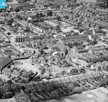
EAW022957 ENGLAND (1949). Manor Lane, the Drill Hall (TA Centre) on Lenham Road and the High Street, Sutton, 1949
© Copyright OpenStreetMap contributors and licensed by the OpenStreetMap Foundation. 2025. Cartography is licensed as CC BY-SA.
Nearby Images (17)
Details
| Title | [EAW022957] Manor Lane, the Drill Hall (TA Centre) on Lenham Road and the High Street, Sutton, 1949 |
| Reference | EAW022957 |
| Date | 6-May-1949 |
| Link | |
| Place name | SUTTON |
| Parish | |
| District | |
| Country | ENGLAND |
| Easting / Northing | 525914, 164395 |
| Longitude / Latitude | -0.19114281924871, 51.36414587495 |
| National Grid Reference | TQ259644 |
Pins
 christhewino |
Monday 9th of January 2023 10:09:56 AM | |
 redmist |
Thursday 14th of October 2021 08:40:12 PM | |
 Falcon |
Thursday 24th of July 2014 09:20:01 PM | |
 Falcon |
Thursday 24th of July 2014 09:14:03 PM | |
 Falcon |
Thursday 24th of July 2014 09:12:11 PM | |
 Falcon |
Thursday 24th of July 2014 08:43:56 PM | |
 Falcon |
Thursday 24th of July 2014 08:43:08 PM | |
 Gaz |
Thursday 24th of July 2014 09:25:51 AM | |
 Gaz |
Thursday 24th of July 2014 09:24:40 AM | |
 Gaz |
Thursday 24th of July 2014 09:23:15 AM | |
Lynda Tubbs |
Tuesday 25th of February 2014 01:55:49 PM | |
 Mark1973 |
Friday 3rd of January 2014 03:19:46 PM |
User Comment Contributions
I used to live in one of the semi detached houses in the bottom left of this shot (facing camera) from 1961 to 1970, when it was known as 'Throwley Road'...during that time the open space immediately behind them was some kind of motor vehicle depot.....the long building going out of shot on the left of the houses was a roller skating rink and left of that was a bakery...the alleyway to the right of the houses went through to the High Street and came out between the local M&S and Woolworths. All that corner has now disappeared under the 'Throwley Way'/ multi storey car park development. |
 martin |
Thursday 24th of July 2014 07:17:32 PM |
Lynda Tubbs |
Tuesday 1st of April 2014 02:18:01 PM |


![[EAW022957] Manor Lane, the Drill Hall (TA Centre) on Lenham Road and the High Street, Sutton, 1949](http://britainfromabove.org.uk/sites/all/libraries/aerofilms-images/public/100x100/EAW/022/EAW022957.jpg)
![[EAW022941] Manor Lane by the Employment Exchange, Sutton, 1949](http://britainfromabove.org.uk/sites/all/libraries/aerofilms-images/public/100x100/EAW/022/EAW022941.jpg)
![[EAW022943] Sanitary Appliances Ltd Works and Manor Lane, Sutton, 1949](http://britainfromabove.org.uk/sites/all/libraries/aerofilms-images/public/100x100/EAW/022/EAW022943.jpg)
![[EAW022954] Manor Lane and the High Street, Sutton, 1949](http://britainfromabove.org.uk/sites/all/libraries/aerofilms-images/public/100x100/EAW/022/EAW022954.jpg)
![[EAW022946] Manor Lane, Lodge Road and the High Street, Sutton, 1949](http://britainfromabove.org.uk/sites/all/libraries/aerofilms-images/public/100x100/EAW/022/EAW022946.jpg)
![[EAW022956] Manor Lane and the High Street, Sutton, 1949](http://britainfromabove.org.uk/sites/all/libraries/aerofilms-images/public/100x100/EAW/022/EAW022956.jpg)
![[EAW022942] The High Street and Lodge Road, Sutton, 1949](http://britainfromabove.org.uk/sites/all/libraries/aerofilms-images/public/100x100/EAW/022/EAW022942.jpg)
![[EAW022945] Manor Lane, Lodge Road and the High Street, Sutton, 1949](http://britainfromabove.org.uk/sites/all/libraries/aerofilms-images/public/100x100/EAW/022/EAW022945.jpg)
![[EPW050017] The town centre, Sutton, 1936. This image has been produced from a print.](http://britainfromabove.org.uk/sites/all/libraries/aerofilms-images/public/100x100/EPW/050/EPW050017.jpg)
![[EAW022944] Manor Lane and the High Street, Sutton, 1949](http://britainfromabove.org.uk/sites/all/libraries/aerofilms-images/public/100x100/EAW/022/EAW022944.jpg)
![[EAW022940] Manor Lane by the Employment Exchange and the High Street, Sutton, 1949](http://britainfromabove.org.uk/sites/all/libraries/aerofilms-images/public/100x100/EAW/022/EAW022940.jpg)
![[EPW057033] The High Street, Sutton, 1938](http://britainfromabove.org.uk/sites/all/libraries/aerofilms-images/public/100x100/EPW/057/EPW057033.jpg)
![[EPW001674] Sutton High Street and area, Sutton, 1920](http://britainfromabove.org.uk/sites/all/libraries/aerofilms-images/public/100x100/EPW/001/EPW001674.jpg)
![[EPW028239] The High Street and the town, Sutton, 1929](http://britainfromabove.org.uk/sites/all/libraries/aerofilms-images/public/100x100/EPW/028/EPW028239.jpg)
![[EPW028245] The High Street, Sutton, 1929](http://britainfromabove.org.uk/sites/all/libraries/aerofilms-images/public/100x100/EPW/028/EPW028245.jpg)
![[EPW011424] Manor Lane, Benhill Avenue and environs, Sutton, 1924. This image has been produced from a print.](http://britainfromabove.org.uk/sites/all/libraries/aerofilms-images/public/100x100/EPW/011/EPW011424.jpg)
![[EPW028249] The High Street and environs, Sutton, 1929](http://britainfromabove.org.uk/sites/all/libraries/aerofilms-images/public/100x100/EPW/028/EPW028249.jpg)
