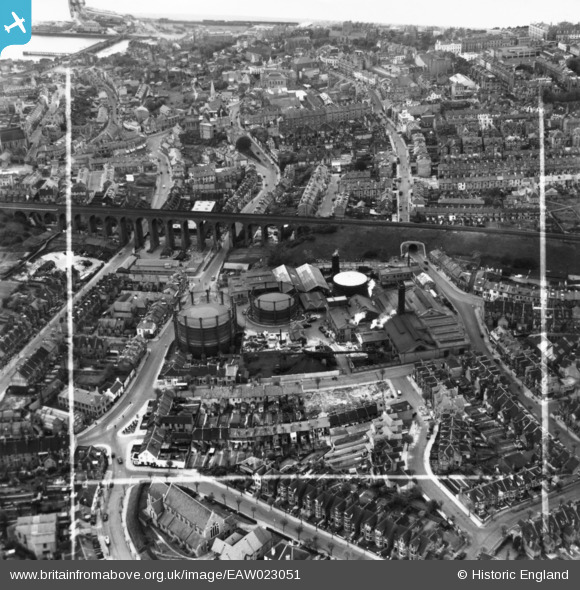
EAW023051 ENGLAND (1949). The Gas Works on Foord Road and environs, Folkestone, 1949. This image has been produced from a print marked by Aerofilms Ltd for photo editing.
© Copyright OpenStreetMap contributors and licensed by the OpenStreetMap Foundation. 2024. Cartography is licensed as CC BY-SA.
Nearby Images (6)
Details
| Title | [EAW023051] The Gas Works on Foord Road and environs, Folkestone, 1949. This image has been produced from a print marked by Aerofilms Ltd for photo editing. |
| Reference | EAW023051 |
| Date | 10-May-1949 |
| Link | |
| Place name | FOLKESTONE |
| Parish | FOLKESTONE |
| District | |
| Country | ENGLAND |
| Easting / Northing | 622624, 136440 |
| Longitude / Latitude | 1.1790104760626, 51.08347845726 |
| National Grid Reference | TR226364 |
Pins
 Jacqui |
Monday 14th of November 2016 08:20:16 PM | |
 Jacqui |
Monday 14th of November 2016 08:17:18 PM |


![[EAW023051] The Gas Works on Foord Road and environs, Folkestone, 1949. This image has been produced from a print marked by Aerofilms Ltd for photo editing.](http://britainfromabove.org.uk/sites/all/libraries/aerofilms-images/public/100x100/EAW/023/EAW023051.jpg)
![[EAW023048] The Gas Works on Foord Road and environs, Folkestone, 1949](http://britainfromabove.org.uk/sites/all/libraries/aerofilms-images/public/100x100/EAW/023/EAW023048.jpg)
![[EAW023049] The Gas Works on Foord Road and environs, Folkestone, 1949. This image has been produced from a print marked by Aerofilms Ltd for photo editing.](http://britainfromabove.org.uk/sites/all/libraries/aerofilms-images/public/100x100/EAW/023/EAW023049.jpg)
![[EAW023050] The Gas Works on Foord Road and environs, Folkestone, 1949. This image has been produced from a print marked by Aerofilms Ltd for photo editing.](http://britainfromabove.org.uk/sites/all/libraries/aerofilms-images/public/100x100/EAW/023/EAW023050.jpg)
![[EAW023053] The Gas Works on Foord Road and environs, Folkestone, 1949. This image has been produced from a print marked by Aerofilms Ltd for photo editing.](http://britainfromabove.org.uk/sites/all/libraries/aerofilms-images/public/100x100/EAW/023/EAW023053.jpg)
![[EAW023052] The Gas Works on Foord Road and environs, Folkestone, 1949. This image has been produced from a print marked by Aerofilms Ltd for photo editing.](http://britainfromabove.org.uk/sites/all/libraries/aerofilms-images/public/100x100/EAW/023/EAW023052.jpg)